METAR & TAF 12Y
12Y does not publish a METAR.
Showing the nearest reporting station: KMKT (MANKATO RGNL) · 13.1 NM away. Conditions at 12Y may differ.
METAR · KMKT
Observed 01:56Z
KMKT 270156Z AUTO 17004KT 10SM CLR 29/28 A2979 RMK AO2 SLP078 T02940278
- Wind
- 170° @ 4 kt
- Visibility
- 10 SM
- Temp / Dew
- 29°C / 28°C
- Altimeter
- 29.79 inHg
- Clouds
- CLR
- Density alt
- 2,917 ft
- Ceiling
- Unlimited
- Rules
- VFR
Airport info & contacts
Manager on record, flight service, ARTCC, attendance schedule and pattern altitude — published by the FAA and refreshed every 28 days.
Location
- From city
- 2 NM S
- VFR sectional
- OMAHA
- ARTCC
- ZMP · MINNEAPOLIS
- NOTAM facility
- PNM (NOTAM-D)
Airport manager
- Name
- JOEL SCHMIDT
- Phone
- 507-593-8378
- Address
- 505 BORIGHT ST, LE SUEUR MN 56058-1452
Flight service · Hours
- FSS PNM
- PRINCETON1-800-WX-BRIEF
- Attendance
- MON-FRI · 0800-1700
Frequencies
Tap any row to copy the frequency to your clipboard.
Runways & pattern
Full pagePattern entry · RWY 13
LEFT TRAFFICRunway end performance
| End | TORA | TODA | ASDA | LDA | VGSI | Approach lights | Obstruction |
|---|---|---|---|---|---|---|---|
| 13 | — | — | — | — | PAPI 4-box left(2.75°) | — | — |
| 31 | — | — | — | — | PAPI 4-box left(2.75°) | — | — |
Declared distances in feet. TORA = takeoff run available, TODA = takeoff distance, ASDA = accelerate-stop, LDA = landing distance.
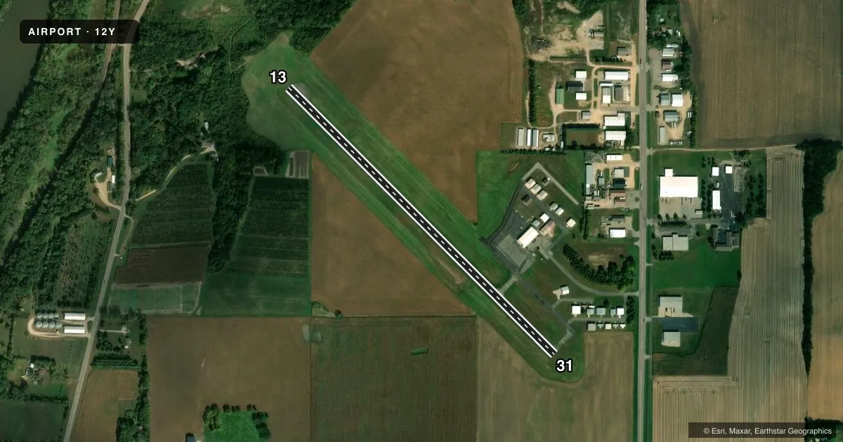
Airport sketch
Runways drawn to scale from FAA survey coordinates, rendered over satellite imagery. Not for navigation.
Approaches & charts
Services on the field
Fuel grades, oxygen, maintenance, ramp storage and lighting — as declared to the FAA by the airport operator.
Fuel & services
- Fuel
- 100LLA
- Oxygen (bottled)
- Not available
- Oxygen (bulk)
- Not available
- Airframe repair
- Minor
- Power plant repair
- Minor
- Other services
- AGRI,CHTR,SALES,SURV
Ramp & ground
- Transient storage
- Tie-down
- Landing fee
- No fee published
- Customs
- Not available
- Lighting schedule
- SEE RMK
- Beacon schedule
- SS-SR
- Beacon
- White / Green (civil land)(WG)
- Wind indicator
- Lighted
- Segmented circle
- No
Fuel & FBOs
Cheapest 100LL and Jet A on the field and nearby. Always confirm with the FBO before taxi.
Airport notes
Surface conditions, obstructions, local procedures, lighting outages and other notes published with each FAA cycle.
General notes
- DEER ON & INVOF ARPT.
- RWY END 13 NOT VSB FM RWY END 31.
- FOR CD CTC MINNEAPOLIS ARTCC AT 651-463-5588.
Lighting notes
- ACTVT OR INCR INTST REIL RWY 13 & 31; PAPI RWY 13 & 31; MIRL RWY 13/31 - CTAF. MIRL RWY 13/31 PRESET LOW INTST.
Fuel notes
- 100LL100LL AVBL H24 SELF SVC VIA CREDIT CARD.
VFR map & nearby airports
VFR sectional. Tap any ICAO chip to open that airport.
Key facts · 12Y
Answer card- ICAO
- 12Y
- Name
- LE SUEUR MUNI
- Location
- LE SUEUR, MINNESOTA
- Elevation
- 867.5 ft MSL
- Traffic pattern altitude
- 1,867.5 ft MSL (1,000 AGL)
- Control tower
- Non-towered (use CTAF)
- Total runways
- 1
- Longest runway
- 13/31 · 3,000 ft
- Published ILS approaches
- 0
- Published frequencies
- 1
- Magnetic variation
- 4°
- Current flight rules
- VFR
- Current wind
- 170° at 4 kt
- Favored runway now
- RWY 13
Le Sueur Muni sits in Le Sueur, Minnesota. Field elevation is 867.5 ft MSL. The airport has one runway. Runway 13/31 is 3,000 ft long and asphalt. There is no control tower, so traffic works on CTAF 122.9.
No ILS approaches are published here. Pattern altitude is not published, so plan on the standard 1,000 ft AGL for light piston traffic unless the current FAA Chart Supplement says otherwise. The field has precision approach path indicators on both runway ends. Runway end identifier lights are available on 13 and 31. The runway lights are medium intensity and are controlled by CTAF. They are preset to low intensity.
Le Sueur Municipal Airport is the on-field FBO. It carries AVGAS 100LL. Self-serve 100LL is available 24 hours a day by credit card. Deer are reported on and near the airport, so keep a sharp scan on taxi, takeoff and landing. Runway 13 is not visible from runway 31. Brief your back taxi and departure flow before you roll. For clearance delivery, contact Minneapolis ARTCC at 651-463-5588.