METAR & TAF KAHH
KAHH does not publish a METAR.
Showing the nearest reporting station: KRNH (NEW RICHMOND RGNL) · 10.6 NM away. Conditions at KAHH may differ.
METAR · KRNH
Observed 18:10Z
KRNH 121810Z AUTO 29018G23KT 10SM CLR 23/10 A2983 RMK AO2 T02310103
- Wind
- 290° @ 18G23 kt
- Visibility
- 10 SM
- Temp / Dew
- 23°C / 10°C
- Altimeter
- 29.83 inHg
- Clouds
- CLR
- Density alt
- 2,421 ft
- Ceiling
- Unlimited
- Rules
- VFR
Airport info & contacts
Manager on record, flight service, ARTCC, attendance schedule and pattern altitude — published by the FAA and refreshed every 28 days.
Location
- From city
- 2 NM S
- VFR sectional
- GREEN BAY
- ARTCC
- ZMP · MINNEAPOLIS
- NOTAM facility
- GRB (NOTAM-D)
Airport manager
- Name
- RAY TOLLIVER
- Phone
- 715-268-8932
- Address
- 104 MAPLE STREET W, SUITE A, AMERY WI 54001
Flight service · Hours
- FSS GRB
- GREEN BAY1-800-WX-BRIEF
- Attendance
- Unattended
Frequencies
Tap any row to copy the frequency to your clipboard.
Runways & pattern
Full pagePattern entry · RWY 36
LEFT TRAFFICRunway end performance
| End | TORA | TODA | ASDA | LDA | VGSI | Approach lights | Obstruction |
|---|---|---|---|---|---|---|---|
| 18 | — | — | — | — | PAPI 4-box left(4°) | — | — |
| 36 | — | — | — | — | PAPI 4-box left(3°) | — | 28', tree, 650' from thr, 210' R of cntrln, slope 16 |
Declared distances in feet. TORA = takeoff run available, TODA = takeoff distance, ASDA = accelerate-stop, LDA = landing distance.
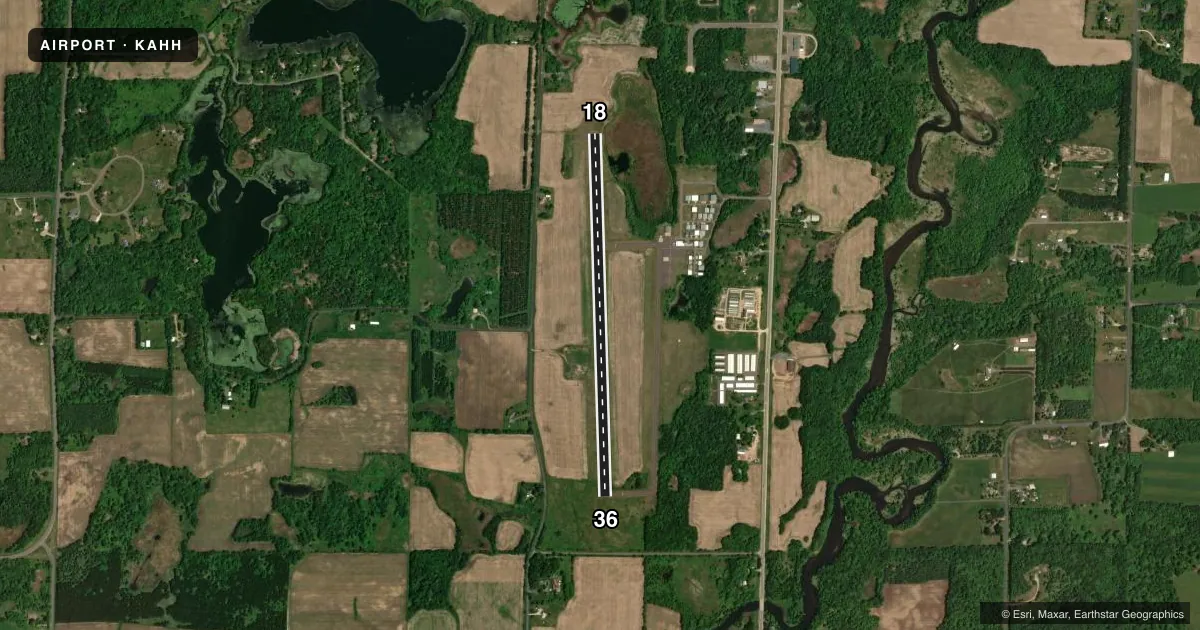
Airport sketch
Runways drawn to scale from FAA survey coordinates, rendered over satellite imagery. Not for navigation.
Approaches & charts
Services on the field
Fuel grades, oxygen, maintenance, ramp storage and lighting — as declared to the FAA by the airport operator.
Fuel & services
- Fuel
- 100LLA
- Oxygen (bottled)
- Not available
- Oxygen (bulk)
- Not available
- Airframe repair
- Not available
- Power plant repair
- Not available
Ramp & ground
- Transient storage
- Tie-down
- Hangar
- Landing fee
- No fee published
- Customs
- Not available
- Lighting schedule
- SEE RMK
- Beacon schedule
- SS-SR
- Beacon
- White / Green (civil land)(WG)
- Wind indicator
- Lighted
- Segmented circle
- No
Fuel & FBOs
Cheapest 100LL and Jet A on the field and nearby. Always confirm with the FBO before taxi.
Airport notes
Surface conditions, obstructions, local procedures, lighting outages and other notes published with each FAA cycle.
General notes
- FOR CD CTC MINNEAPOLIS ARTCC AT 651-463-5588.
Lighting notes
- MIRL RWY 18/36 PRESET TO LOW SS-SR; TO INCR INTST AND ACTVT REIL RWY 18 & 36; PAPI RWY 18 & 36 - CTAF.
Fuel notes
- 100LLFUEL AVBL H24 VIA CREDIT CARD.
Approach & departure obstructions
- 18UNUSBL BYD 8 DEG RIGHT OF CNTRLN.
VFR map & nearby airports
VFR sectional. Tap any ICAO chip to open that airport.
Key facts · KAHH
Answer card- ICAO
- KAHH
- Name
- AMERY MUNI
- Location
- AMERY, WISCONSIN
- Elevation
- 1,088.1 ft MSL
- Traffic pattern altitude
- 2,088.1 ft MSL (1,000 AGL)
- Control tower
- Non-towered (use CTAF)
- Total runways
- 1
- Longest runway
- 18/36 · 4,002 ft
- Published ILS approaches
- 0
- Published frequencies
- 2
- Magnetic variation
- 1°
- Current flight rules
- VFR
- Current wind
- 290° at 18 kt
- Favored runway now
- RWY 36
Amery Muni sits in Amery, Wisconsin. The field elevation is 1,088.1 ft MSL. It has one runway. Runway 18/36 is 4,002 ft long with an asphalt surface. There is no control tower. CTAF and UNICOM are both 122.8. No ILS approaches are published here.
Pattern altitude is not published. Use the standard 1,000 ft AGL for light piston traffic unless local procedures or the current Chart Supplement say otherwise. The airport is in a non-towered environment. Listen well and make your calls early. Clearance delivery for IFR departures goes through Minneapolis ARTCC at 651-463-5588.
Amery Municipal Airport is the on-field FBO. It carries 100LL and JET A. 100LL is available 24 hours a day by credit card. Runway 18 has a visual glide slope indicator, but it is unusable beyond 8 degrees right of centerline. The runway lighting is preset to low from sunset to sunrise. Use the CTAF to increase intensity and to activate the runway end identifier lights and the precision approach path indicators for 18 and 36.
For a first-time arrival, the main things to know are the non-towered traffic flow, the published lighting activation and the runway 18 VASI limitation. Check the current Chart Supplement for any updated remarks before you go.