METAR & TAF KUBE
Current METAR
Observed 20:15Z
KUBE 272015Z AUTO 33015KT 10SM BKN023 BKN030 OVC035 28/23 A2974 RMK AO2
- Wind
- 330° @ 15 kt
- Visibility
- 10 SM
- Temp / Dew
- 28°C / 23°C
- Altimeter
- 29.74 inHg
- Clouds
- OVC
- Density alt
- 3,324 ft
- Ceiling
- 2,300 ft AGL
- Rules
- MVFR
Airport info & contacts
Manager on record, flight service, ARTCC, attendance schedule and pattern altitude — published by the FAA and refreshed every 28 days.
Location
- From city
- 3 NM SE
- VFR sectional
- GREEN BAY
- ARTCC
- ZMP · MINNEAPOLIS
- NOTAM facility
- GRB (NOTAM-D)
Airport manager
- Name
- RICK BREKKE
- Phone
- 715-205-4474
- Address
- 224 241/2 AVENUE, CUMBERLAND WI 54829
Flight service · Hours
- FSS GRB
- GREEN BAY1-800-WX-BRIEF
- Attendance
- MON - FRI · 0800-1700
Frequencies
Tap any row to copy the frequency to your clipboard.
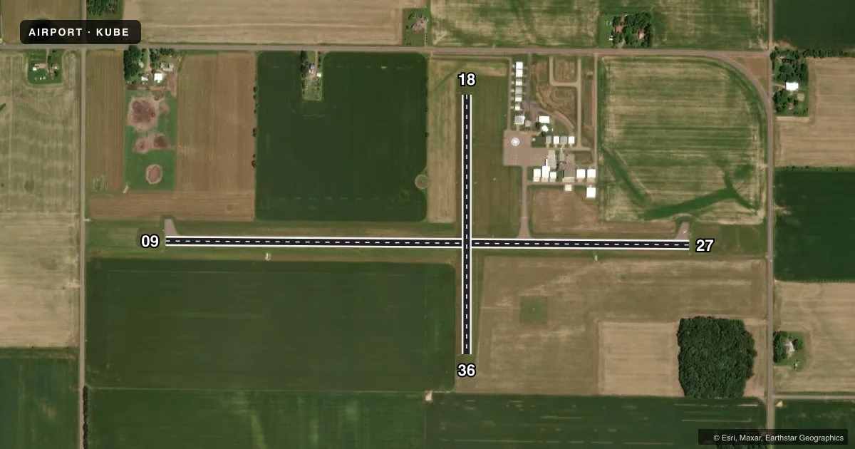
Runways & pattern
Full pagePattern entry · RWY 36
LEFT TRAFFIC| Runway | Heading (°M) | Length | Surface | Traffic |
|---|---|---|---|---|
| 09/27 | 89° / 269° | 4,043 ft | ASPH | Standard L |
| 18/36Favored | 179° / 359° | 1,996 ft | TURF | Standard L |
Runway end performance
| End | TORA | TODA | ASDA | LDA | VGSI | Approach lights | Obstruction |
|---|---|---|---|---|---|---|---|
| 09 | — | — | — | — | PAPI 2-box right(3°) | — | — |
| 27 | — | — | — | — | PAPI 2-box left(3°) | — | — |
Declared distances in feet. TORA = takeoff run available, TODA = takeoff distance, ASDA = accelerate-stop, LDA = landing distance.
Airport sketch
Runways drawn to scale from FAA survey coordinates, rendered over satellite imagery. Not for navigation.
Approaches & charts
Services on the field
Fuel grades, oxygen, maintenance, ramp storage and lighting — as declared to the FAA by the airport operator.
Fuel & services
- Fuel
- 100LLUL94
- Oxygen (bottled)
- Not available
- Oxygen (bulk)
- Not available
- Airframe repair
- Major
- Power plant repair
- Major
- Other services
- INSTR,RNTL
Ramp & ground
- Transient storage
- Tie-down
- Hangar
- Landing fee
- No fee published
- Customs
- Not available
- Lighting schedule
- SEE RMK
- Beacon schedule
- SS-SR
- Beacon
- White / Green (civil land)(WG)
- Wind indicator
- Lighted
- Segmented circle
- Yes
Fuel & FBOs
Cheapest 100LL and Jet A on the field and nearby. Always confirm with the FBO before taxi.
Airport notes
Surface conditions, obstructions, local procedures, lighting outages and other notes published with each FAA cycle.
General notes
- GCO AVBL ON FREQ 121.725 THRU FLT SVCS.
- FOR CD CTC MINNEAPOLIS ARTCC AT 651-463-5588.
Lighting notes
- MIRL RWY 09/27 PRESET ON LOW SS-SR, TO INCR INTST & ACTVT REIL RWY 9 & 27 - CTAF. PAPI RWY 09 & 27 OPR CONSLY.
Fuel notes
- 100LL24 HR FUEL AVBL.
Runway surface & condition
- 18/36RWY 18/36 NOT PLOWED WINTER MONTHS.
Approach & departure obstructions
- 18RWY 18 MKD WITH YELLOW CONES.
- 36RWY 36 MKD WITH YELLOW CONES.
Other notes
- DETERMINATION PENDING.
- OWNERARPT PHONE 715-822-4554.
VFR map & nearby airports
VFR sectional. Tap any ICAO chip to open that airport.
Key facts · KUBE
Answer card- ICAO
- KUBE
- Name
- CUMBERLAND MUNI
- Location
- CUMBERLAND, WISCONSIN
- Elevation
- 1,242.9 ft MSL
- Traffic pattern altitude
- 2,242.9 ft MSL (1,000 AGL)
- Control tower
- Non-towered (use CTAF)
- Total runways
- 2
- Longest runway
- 09/27 · 4,043 ft
- Published ILS approaches
- 0
- Published frequencies
- 2
- Magnetic variation
- 1°
- Current flight rules
- MVFR
- Current wind
- 330° at 15 kt
- Favored runway now
- RWY 36
Cumberland Muni sits in Cumberland, Wisconsin. Field elevation is 1,242.9 ft MSL. The airport has two runways. The longest is 09/27 at 4,043 ft. There is no control tower, so expect self-announce traffic on CTAF 122.8. No ILS approaches are published here. Pattern altitude is not published. Use the standard 1,000 ft AGL pattern for light piston aircraft unless the current Chart Supplement says otherwise.
The on-field FBO is Cumberland Municipal Airport. It carries 100LL and UL94. 24-hour fuel is available. The published remarks also note yellow cones on runway 18 and runway 36. Runway 18/36 is not plowed in winter. That matters if you are planning a cold-weather arrival. Runway 09/27 has medium intensity lights that come up low from sunset to sunrise. Use the CTAF to increase intensity and to activate the runway end identifier lights. PAPI is listed for 09 and 27. The field has a ground communications outlet on 121.725 through flight services. For clearance delivery, contact Minneapolis ARTCC. This is a non-towered field with a turf runway and a paved runway. Check runway condition and wind before you commit, especially in winter or when the turf is soft.