METAR & TAF KRZN
Current METAR
Observed 21:55Z
KRZN 272155Z AUTO 03008KT 10SM CLR 28/20 A2979 RMK AO2 T02750196
- Wind
- 030° @ 8 kt
- Visibility
- 10 SM
- Temp / Dew
- 28°C / 20°C
- Altimeter
- 29.79 inHg
- Clouds
- CLR
- Density alt
- 2,948 ft
- Ceiling
- Unlimited
- Rules
- VFR
Airport info & contacts
Manager on record, flight service, ARTCC, attendance schedule and pattern altitude — published by the FAA and refreshed every 28 days.
Location
- From city
- 3 NM N
- VFR sectional
- GREEN BAY
- ARTCC
- ZMP · MINNEAPOLIS
- NOTAM facility
- RZN (NOTAM-D)
Airport manager
- Name
- NATHAN EHALT
- Phone
- 715-222-1702
- Address
- 7410 CTH K, SUITE #116, SIREN WI 54872
Flight service · Hours
- FSS GRB
- GREEN BAY1-800-WX-BRIEF
- Attendance
- MON-FRI · 0800-1630
- SAT-SUN · IREG
Frequencies
Tap any row to copy the frequency to your clipboard.
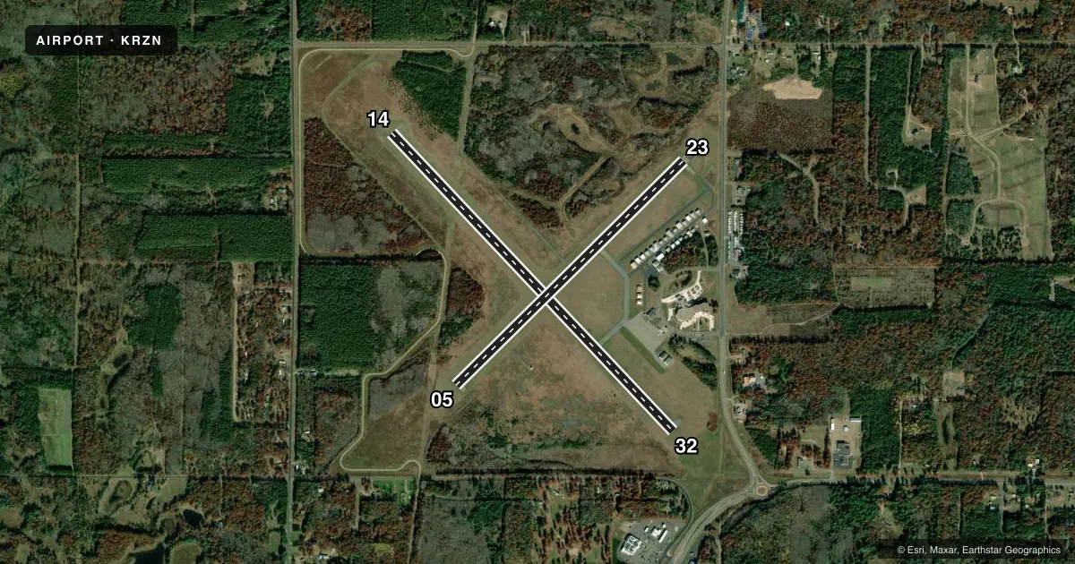
Runways & pattern
Full pagePattern entry · RWY 05
LEFT TRAFFIC| Runway | Heading (°M) | Length | Surface | Traffic |
|---|---|---|---|---|
| 14/32 | 136° / 316° | 5,000 ft | ASPH | Standard L |
| 05/23Favored | 44° / 224° | 3,900 ft | ASPH | Standard L |
Runway end performance
| End | TORA | TODA | ASDA | LDA | VGSI | Approach lights | Obstruction |
|---|---|---|---|---|---|---|---|
| 14 | — | — | — | — | PAPI 2-box left(3°) | — | — |
| 32 | — | — | — | — | PAPI 2-box left(4°) | — | 85', trees, 1378' from thr, 115' R of cntrln, slope 13 |
| 05 | — | — | — | — | PAPI 2-box left(3.5°) | — | 35', trees, 500' from thr, 260' R of cntrln, slope 8 |
| 23 | — | — | — | — | PAPI 2-box left(3°) | — | 15', road, 382' from thr, 277' R of cntrln, slope 12 |
Declared distances in feet. TORA = takeoff run available, TODA = takeoff distance, ASDA = accelerate-stop, LDA = landing distance.
Airport sketch
Runways drawn to scale from FAA survey coordinates, rendered over satellite imagery. Not for navigation.
Approaches & charts
Services on the field
Fuel grades, oxygen, maintenance, ramp storage and lighting — as declared to the FAA by the airport operator.
Fuel & services
- Fuel
- 100LLA+
- Airframe repair
- Minor
- Power plant repair
- Minor
- Other services
- INSTR
Ramp & ground
- Transient storage
- Tie-down
- Hangar
- Landing fee
- No fee published
- Customs
- Not available
- Lighting schedule
- SEE RMK
- Beacon schedule
- SS-SR
- Beacon
- White / Green (civil land)(WG)
- Wind indicator
- Lighted
- Segmented circle
- Yes
Fuel & FBOs
Cheapest 100LL and Jet A on the field and nearby. Always confirm with the FBO before taxi.
Airport notes
Surface conditions, obstructions, local procedures, lighting outages and other notes published with each FAA cycle.
General notes
- WILDLIFE ON & INVOF OF RWY.
- FOR CD CTC MINNEAPOLIS ARTCC AT 651-463-5588.
Lighting notes
- ACTVT REIL RWY 05, 14, 23 & 32; PAPI RWY 05, 14, 23 & 32; MIRL RWY 05/23 & 14/32 - CTAF. SS-SR: MIRL RWY 14/32 PRESET TO LOW; INCR INTST - CTAF.
Fuel notes
- 100LLSELF SVC H24 WITH CREDIT CARD.
Approach & departure obstructions
- 05UNUSBL BYD 5 DEGS RIGHT OF CNTRLN.
- 32APCH RATIO 20:1 TO DTHR.
Other notes
- MANAGERAFT HR - 715-222-1702/715-566-2557.
VFR map & nearby airports
VFR sectional. Tap any ICAO chip to open that airport.
Key facts · KRZN
Answer card- ICAO
- KRZN
- Name
- BURNETT COUNTY
- Location
- SIREN, WISCONSIN
- Elevation
- 989.3 ft MSL
- Traffic pattern altitude
- 1,989.3 ft MSL (1,000 AGL)
- Control tower
- Non-towered (use CTAF)
- Total runways
- 2
- Longest runway
- 14/32 · 5,000 ft
- Published ILS approaches
- 0
- Published frequencies
- 2
- Magnetic variation
- 1°
- Current flight rules
- VFR
- Current wind
- 030° at 8 kt
- Favored runway now
- RWY 05
Burnett County Airport is in Siren, Wisconsin. The field elevation is 989.3 ft MSL. It has two asphalt runways. The longest is 5,000 ft on runway 14/32. There is no control tower, so plan for CTAF traffic and self-announced position reports on 122.8. No ILS approaches are published here.
Pattern altitude is not published. Use the standard 1,000 ft AGL pattern unless the current Chart Supplement or local procedures say otherwise. Burnett County Airport carries AVGAS 100LL and Jet A Prist through the on-field airport fuel setup. 100LL is self-serve 24 hours with credit card. After hours contact numbers are published for the manager if you need help on arrival or departure.
The runway lighting setup is useful to know before you go. Runway end identifier lights are published for both runways. PAPI is available on 05, 14, 23 and 32. Medium intensity runway lights are available for both runways and are controlled by CTAF. Runway 14/32 is preset to low intensity from sunset to sunrise. You can increase it by CTAF. There is also a published note that the runway 05 visual glide slope indicator is unusable beyond 5 degrees right of centerline. Wildlife is reported on and near the runway, so keep a sharp scan on taxi, takeoff and landing.