METAR & TAF Y50
Current METAR
Observed 17:28Z
KY50 261728Z AUTO 21005KT 10SM SCT022 28/23 A2991 RMK AO2
- Wind
- 210° @ 5 kt
- Visibility
- 10 SM
- Temp / Dew
- 28°C / 23°C
- Altimeter
- 29.91 inHg
- Clouds
- SCT
- Density alt
- 2,638 ft
- Ceiling
- Unlimited
- Rules
- VFR
Airport info & contacts
Manager on record, flight service, ARTCC, attendance schedule and pattern altitude — published by the FAA and refreshed every 28 days.
Location
- From city
- 2 NM SW
- VFR sectional
- GREEN BAY
- ARTCC
- ZAU · CHICAGO
- NOTAM facility
- GRB (NOTAM-D)
Airport manager
- Name
- RICHARD JORGENSEN
- Phone
- 920-787-3030
- Address
- W8471 COTTONVILLE DRIVE, WAUTOMA WI 54982
Flight service · Hours
- FSS GRB
- GREEN BAY1-800-WX-BRIEF
- Attendance
- 0700-1900
Frequencies
Tap any row to copy the frequency to your clipboard.
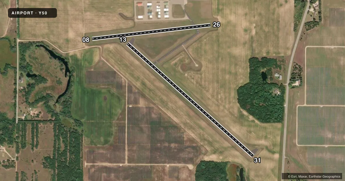
Runways & pattern
Full pagePattern entry · RWY 26
LEFT TRAFFIC| Runway | Heading (°M) | Length | Surface | Traffic |
|---|---|---|---|---|
| 13/31 | 130° / 310° | 3,300 ft | ASPH | Standard L |
| 08/26Favored | 81° / 261° | 2,334 ft | TURF | Standard L |
Runway end performance
| End | TORA | TODA | ASDA | LDA | VGSI | Approach lights | Obstruction |
|---|---|---|---|---|---|---|---|
| 13 | — | — | — | — | — | — | 88', trees, 1350' from thr, 350' R of cntrln, slope 13 |
| 31 | — | — | — | — | — | — | 67', tree, 1075' from thr, 275' R of cntrln, slope 13 |
| 08 | — | — | — | — | — | — | 60', trees, 850' from thr, 75' R of cntrln, slope 14 |
Declared distances in feet. TORA = takeoff run available, TODA = takeoff distance, ASDA = accelerate-stop, LDA = landing distance.
Airport sketch
Runways drawn to scale from FAA survey coordinates, rendered over satellite imagery. Not for navigation.
Approaches & charts
Services on the field
Fuel grades, oxygen, maintenance, ramp storage and lighting — as declared to the FAA by the airport operator.
Fuel & services
- Fuel
- 100LL
- Oxygen (bottled)
- Not available
- Oxygen (bulk)
- Not available
- Airframe repair
- Minor
- Power plant repair
- Major
- Other services
- INSTR
Ramp & ground
- Transient storage
- Tie-down
- Hangar
- Landing fee
- No fee published
- Customs
- Not available
- Lighting schedule
- SEE RMK
- Beacon schedule
- SS-SR
- Beacon
- White / Green (civil land)(WG)
- Wind indicator
- Lighted
- Segmented circle
- Yes
Fuel & FBOs
Cheapest 100LL and Jet A on the field and nearby. Always confirm with the FBO before taxi.
Airport notes
Surface conditions, obstructions, local procedures, lighting outages and other notes published with each FAA cycle.
General notes
- WATERFOWL AND DEER ON AND INVOF ARPT.
- ULTRALIGHT ACTIVITY ON & INVOF ARPT.
- FOR CD CTC CHICAGO ARTCC AT 630-906-8921.
Lighting notes
- MIRL RWY 13/31 PRESET TO LOW SS-SR; TO INCR INTST AND ACTVT - CTAF.
Fuel notes
- 100LL24 HR SELF SVC FUEL AVBL WITH CREDIT CARD.
Runway surface & condition
- 08/26RY 08/26 CLSD WINTER MONTHS EXCEPT FOR SKI EQUIPPED ACFT. E 430 FT CLSD IN WINTER.
Approach & departure obstructions
- 08MKD WITH WHITE HALF BARRELS.
- 26MKD WITH WHITE HALF BARRELS.
VFR map & nearby airports
VFR sectional. Tap any ICAO chip to open that airport.
Key facts · Y50
Answer card- ICAO
- Y50
- Name
- WAUTOMA MUNI
- Location
- WAUTOMA, WISCONSIN
- Elevation
- 859 ft MSL
- Traffic pattern altitude
- 1,859 ft MSL (1,000 AGL)
- Control tower
- Non-towered (use CTAF)
- Total runways
- 2
- Longest runway
- 13/31 · 3,300 ft
- Published ILS approaches
- 0
- Published frequencies
- 4
- Magnetic variation
- 2°
- Current flight rules
- VFR
- Current wind
- 210° at 5 kt
- Favored runway now
- RWY 26
Wautoma Muni sits in Wautoma, Wisconsin at 859 ft MSL. It has two runways. The longest is 13/31 at 3,300 ft. The other runway is 08/26 at 2,334 ft turf. There is no control tower. Pattern altitude is not published, so use the standard 1,000 ft AGL for light piston traffic unless the current Chart Supplement says otherwise.
No ILS approaches are published here. The field uses Milwaukee approach and departure frequencies for IFR handling. CTAF and UNICOM are both 122.8. The published remarks matter here. Ultralight activity occurs on and near the airport. Deer and waterfowl are also reported in the area. Clearance delivery is handled through Chicago ARTCC.
Wautoma Municipal Airport is the on-field FBO. It carries 100LL. Twenty-four hour self-service fuel is available with a credit card. Runway 13/31 has medium intensity lights that are preset low from sunset to sunrise. Use CTAF to increase intensity and activate them. Runway 08/26 is closed in winter months except for ski-equipped aircraft. The east 430 ft of 08/26 is also closed in winter. White half barrels mark both ends of 08/26. For a first-time arrival, plan for mixed traffic, wildlife and seasonal runway limits before you go.