METAR & TAF 93C
93C does not publish a METAR.
Showing the nearest reporting station: KLNR (TRI-COUNTY RGNL) · 6.7 NM away. Conditions at 93C may differ.
METAR · KLNR
Observed 11:08Z
KLNR 271108Z AUTO 00000KT M1/4SM FG VV002 24/24 A2978 RMK AO2 T02440244
- Wind
- 000° @ 0 kt
- Visibility
- —
- Temp / Dew
- 24°C / 24°C
- Altimeter
- 29.78 inHg
- Clouds
- VV
- Density alt
- 2,174 ft
- Ceiling
- 200 ft AGL
- Rules
- LIFR
Airport info & contacts
Manager on record, flight service, ARTCC, attendance schedule and pattern altitude — published by the FAA and refreshed every 28 days.
Location
- From city
- 4 NM SE
- VFR sectional
- CHICAGO
- ARTCC
- ZAU · CHICAGO
- NOTAM facility
- GRB (NOTAM-D)
Airport manager
- Name
- JASEN GLASBRENNER
- Phone
- 608-647-3466
- Address
- 450 S MAIN ST, RICHLAND CENTER WI 53581
Flight service · Hours
- FSS GRB
- GREEN BAY1-800-WX-BRIEF
- Attendance
- Unattended
Frequencies
Tap any row to copy the frequency to your clipboard.
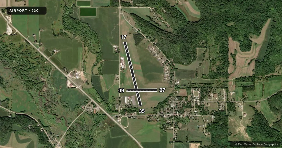
Runways & pattern
Full pagePattern entry · RWY 17
LEFT TRAFFIC| Runway | Heading (°M) | Length | Surface | Traffic |
|---|---|---|---|---|
| 17/35 | 164° / 344° | 3,200 ft | ASPH | Standard L |
| 09/27 | 88° / 268° | 1,500 ft | TURF | Standard L |
Runway end performance
| End | TORA | TODA | ASDA | LDA | VGSI | Approach lights | Obstruction |
|---|---|---|---|---|---|---|---|
| 17 | — | — | — | — | PAPI 2-box left(3.5°) | — | 120', trees, 1950' from thr, 80' R of cntrln, slope 14 |
| 35 | — | — | — | — | PAPI 2-box left(3.5°) | — | — |
| 27 | — | — | — | — | — | — | 62', trees, 870' from thr, 140' R of cntrln, slope 14 |
Declared distances in feet. TORA = takeoff run available, TODA = takeoff distance, ASDA = accelerate-stop, LDA = landing distance.
Airport sketch
Runways drawn to scale from FAA survey coordinates, rendered over satellite imagery. Not for navigation.
Approaches & charts
Services on the field
Fuel grades, oxygen, maintenance, ramp storage and lighting — as declared to the FAA by the airport operator.
Fuel & services
- Fuel
- 100LL
- Oxygen (bottled)
- Not available
- Oxygen (bulk)
- Not available
- Airframe repair
- Not available
- Power plant repair
- Not available
- Other services
- INSTR
Ramp & ground
- Transient storage
- Tie-down
- Landing fee
- No fee published
- Customs
- Not available
- Lighting schedule
- SEE RMK
- Beacon schedule
- SS-SR
- Beacon
- White / Green (civil land)(WG)
- Wind indicator
- Lighted
- Segmented circle
- Yes
Fuel & FBOs
Cheapest 100LL and Jet A on the field and nearby. Always confirm with the FBO before taxi.
Airport notes
Surface conditions, obstructions, local procedures, lighting outages and other notes published with each FAA cycle.
General notes
- ULTRALIGHT ACTVTY ON & IN VCNTY OF ARPT.
- DEER ON & INVOF ARPT.
- RWY 09/27 NOT PLOWED; CONDS UNMON.
- FOR CD CTC CHICAGO ARTCC AT 630-906-8921.
Lighting notes
- ACTVT REIL RWY 17 & 35; PAPI RWY 17 & 35 - CTAF. MIRL RWY 17/35 PRESET TO LOW SS-SR; TO INCR INTST & ACTVT - CTAF.
Fuel notes
- 100LLSELF SVC FUEL AVBL H24 VIA CREDIT CARD.
Approach & departure obstructions
- 09MKD WITH WHITE & ORANGE PANELS AND YELLOW CONES.
- 27MKD WITH WHITE & ORANGE PANELS AND YELLOW CONES.
VFR map & nearby airports
VFR sectional. Tap any ICAO chip to open that airport.
Key facts · 93C
Answer card- ICAO
- 93C
- Name
- RICHLAND
- Location
- RICHLAND CENTER, WISCONSIN
- Elevation
- 742 ft MSL
- Traffic pattern altitude
- 1,742 ft MSL (1,000 AGL)
- Control tower
- Non-towered (use CTAF)
- Total runways
- 2
- Longest runway
- 17/35 · 3,200 ft
- Published ILS approaches
- 0
- Published frequencies
- 1
- Magnetic variation
- 2°
- Current flight rules
- LIFR
- Current wind
- 000° at 0 kt
- Favored runway now
- –
Richland Airport (93C) sits in Richland Center, Wisconsin. The field elevation is 742 ft MSL. It has two runways. The longest is runway 17/35 at 3,200 ft asphalt. Runway 09/27 is 1,500 ft turf. There is no control tower. CTAF is 122.9.
No ILS approaches are published here. Pattern altitude is not published, so use standard traffic pattern planning at 1,000 ft AGL for light piston aircraft unless the current Chart Supplement says otherwise. The published remarks matter here. Runway 17/35 has runway end identifier lights and PAPI, both controlled by CTAF. The medium intensity lights on 17/35 come up at low setting from sunset to sunrise. Runway 27 and runway 09 are marked with white and orange panels plus yellow cones. Self-service 100LL is available 24 hours a day by credit card.
This is an uncontrolled field with local traffic to watch for. Ultralight activity occurs on and near the airport. Deer are also reported on and in the vicinity of the field. Runway 09/27 is not plowed and conditions are unmonitored, so plan for that surface before you go. For clearance delivery, contact Chicago ARTCC at 630-906-8921. If you need current operating details, check the current FAA Chart Supplement or call the airport operator directly.