METAR & TAF KOVS
Current METAR
Observed 16:53Z
KOVS 261653Z AUTO 22005KT 10SM FEW028 SCT036 31/24 A2989 RMK AO2 SLP117 T03060244
- Wind
- 220° @ 5 kt
- Visibility
- 10 SM
- Temp / Dew
- 31°C / 24°C
- Altimeter
- 29.89 inHg
- Clouds
- SCT
- Density alt
- 2,791 ft
- Ceiling
- Unlimited
- Rules
- VFR
Airport info & contacts
Manager on record, flight service, ARTCC, attendance schedule and pattern altitude — published by the FAA and refreshed every 28 days.
Location
- From city
- 2 NM NE
- VFR sectional
- CHICAGO
- ARTCC
- ZAU · CHICAGO
- NOTAM facility
- OVS (NOTAM-D)
Airport manager
- Name
- GLENN GRISWOLD
- Phone
- 608-852-5046
- Address
- 1006 WISCONSIN AVE, BOSCOBEL WI 53805
Flight service · Hours
- FSS GRB
- GREEN BAY1-800-WX-BRIEF
- Attendance
- Unattended
Frequencies
Tap any row to copy the frequency to your clipboard.
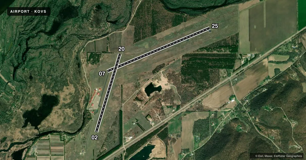
Runways & pattern
Full pagePattern entry · RWY 20
LEFT TRAFFIC| Runway | Heading (°M) | Length | Surface | Traffic |
|---|---|---|---|---|
| 07/25 | 66° / 246° | 5,000 ft | ASPH | Standard L |
| 02/20Favored | 16° / 196° | 3,658 ft | ASPH | Standard L |
Runway end performance
| End | TORA | TODA | ASDA | LDA | VGSI | Approach lights | Obstruction |
|---|---|---|---|---|---|---|---|
| 07 | — | — | — | — | PAPI 2-box left(3°) | — | — |
| 25 | — | — | — | — | PAPI 2-box left(3°) | — | — |
| 02 | — | — | — | — | — | — | 15', trees, 230' from thr, 90' R of cntrln, slope 2 |
| 20 | — | — | — | — | — | — | 26', trees, 405' from thr, 100' R of cntrln, slope 7 |
Declared distances in feet. TORA = takeoff run available, TODA = takeoff distance, ASDA = accelerate-stop, LDA = landing distance.
Airport sketch
Runways drawn to scale from FAA survey coordinates, rendered over satellite imagery. Not for navigation.
Approaches & charts
Services on the field
Fuel grades, oxygen, maintenance, ramp storage and lighting — as declared to the FAA by the airport operator.
Fuel & services
- Fuel
- 100LL
- Oxygen (bottled)
- Not available
- Oxygen (bulk)
- Not available
- Airframe repair
- Major
- Power plant repair
- Major
Ramp & ground
- Transient storage
- Tie-down
- Hangar
- Landing fee
- No fee published
- Customs
- Not available
- Lighting schedule
- SEE RMK
- Beacon schedule
- SS-SR
- Beacon
- White / Green (civil land)(WG)
- Wind indicator
- Yes
- Segmented circle
- No
Fuel & FBOs
Cheapest 100LL and Jet A on the field and nearby. Always confirm with the FBO before taxi.
Airport notes
Surface conditions, obstructions, local procedures, lighting outages and other notes published with each FAA cycle.
General notes
- FOR CD CTC CHICAGO ARTCC AT 630-906-8921.
- COLD TEMPERATURE AIRPORT. ALTITUDE CORRECTION REQUIRED AT OR BELOW -30C.
Lighting notes
- ACTVT REIL RWY 07 & 25; PAPI RWY 07 & 25; MIRL RWY 02/20 - CTAF. MIRL RWY 07/25 PRESET ON LOW INTST, TO INCR INTST & ACTVT - CTAF.
Fuel notes
- 100LL24 HR SELF SERVICE WITH CREDIT CARD.
Other notes
- ESTABLISHED PRIOR TO 1959.
- MANAGERADNL FONE 608-375-5001, EXT 140.
VFR map & nearby airports
VFR sectional. Tap any ICAO chip to open that airport.
Key facts · KOVS
Answer card- ICAO
- KOVS
- Name
- BOSCOBEL
- Location
- BOSCOBEL, WISCONSIN
- Elevation
- 672.6 ft MSL
- Traffic pattern altitude
- 1,672.6 ft MSL (1,000 AGL)
- Control tower
- Non-towered (use CTAF)
- Total runways
- 2
- Longest runway
- 07/25 · 5,000 ft
- Published ILS approaches
- 0
- Published frequencies
- 2
- Magnetic variation
- 1°
- Current flight rules
- VFR
- Current wind
- 220° at 5 kt
- Favored runway now
- RWY 20
Boscobel Airport sits in Boscobel, Wisconsin. Field elevation is 672.6 ft MSL. The airport has two asphalt runways. The longest is 5,000 ft on runway 07/25. There is no control tower. CTAF and UNICOM are both 122.8. No ILS approaches are published here.
Pattern altitude is not published. Use the standard 1,000 ft AGL pattern for light piston traffic unless the current Chart Supplement says otherwise. Boscobel Airport carries AVGAS 100LL through the on-field FBO, Boscobel Airport. 100LL is available 24 hours by self-service with credit card. The field was established before 1959. Runway 07 and 25 have runway end identifier lights. PAPI is available on 07 and 25. MSL runway lights are available on 02/20 and 07/25. For 07/25, the lights start at low intensity and are increased on CTAF.
This is a cold temperature airport. Altitude correction is required at or below minus 30 degrees Celsius. For clearance delivery, contact Chicago ARTCC. The airport is straightforward for local VFR work. Still, verify current runway lighting, cold weather performance and any other operational notes in the current Chart Supplement before you go.