METAR & TAF KLNR
Current METAR
Observed 14:56Z
KLNR 271456Z AUTO 23008KT 10SM FEW085 32/26 A2971 RMK AO2 SLP050 T03170261 58017
- Wind
- 230° @ 8 kt
- Visibility
- 10 SM
- Temp / Dew
- 32°C / 26°C
- Altimeter
- 29.71 inHg
- Clouds
- FEW
- Density alt
- 3,190 ft
- Ceiling
- Unlimited
- Rules
- VFR
Airport info & contacts
Manager on record, flight service, ARTCC, attendance schedule and pattern altitude — published by the FAA and refreshed every 28 days.
Location
- From city
- 2 NM N
- VFR sectional
- CHICAGO
- ARTCC
- ZAU · CHICAGO
- NOTAM facility
- LNR (NOTAM-D)
Airport manager
- Name
- MARK HIGGS
- Phone
- 608-583-2600
- Address
- E2525 CO. HWY JJ, SPRING GREEN WI 53588
Flight service · Hours
- FSS GRB
- GREEN BAY1-800-WX-BRIEF
- Attendance
- MON-FRI · 0800-1700
Frequencies
Tap any row to copy the frequency to your clipboard.
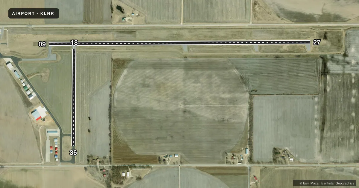
Runways & pattern
Full pagePattern entry · RWY 27
LEFT TRAFFIC| Runway | Heading (°M) | Length | Surface | Traffic |
|---|---|---|---|---|
| 09/27Favored | 89° / 269° | 5,000 ft | ASPH | Standard L |
| 18/36 | 180° / 0° | 1,850 ft | ASPH | Standard L |
Runway end performance
| End | TORA | TODA | ASDA | LDA | VGSI | Approach lights | Obstruction |
|---|---|---|---|---|---|---|---|
| 09 | — | — | — | — | PAPI 2-box left(3°) | — | 34', ant, 1070' from thr, 265' R of cntrln, slope 25 |
| 27 | — | — | — | — | PAPI 2-box left(4°) | — | 300', trees, 7275' from thr, 1260' R of cntrln, slope 23 |
| 18 | — | — | — | — | — | — | 375', trees, 5000' from thr, 530' R of cntrln, slope 12 |
| 36 | — | — | — | — | — | — | 15', road, 380' from thr, 0' R of cntrln, slope 12 |
Declared distances in feet. TORA = takeoff run available, TODA = takeoff distance, ASDA = accelerate-stop, LDA = landing distance.
Airport sketch
Runways drawn to scale from FAA survey coordinates, rendered over satellite imagery. Not for navigation.
Approaches & charts
ILS · 1
Services on the field
Fuel grades, oxygen, maintenance, ramp storage and lighting — as declared to the FAA by the airport operator.
Fuel & services
- Fuel
- 100LLA+
- Oxygen (bottled)
- Not available
- Oxygen (bulk)
- Not available
- Airframe repair
- Major
- Power plant repair
- Minor
Ramp & ground
- Transient storage
- Tie-down
- Landing fee
- No fee published
- Customs
- Not available
- Lighting schedule
- SEE RMK
- Beacon schedule
- SS-SR
- Beacon
- White / Green (civil land)(WG)
- Wind indicator
- Yes
- Segmented circle
- Yes
Fuel & FBOs
Cheapest 100LL and Jet A on the field and nearby. Always confirm with the FBO before taxi.
Airport notes
Surface conditions, obstructions, local procedures, lighting outages and other notes published with each FAA cycle.
General notes
- FOR CD CTC MADISON APP/DEP CON AT 608-249-8240. WHEN MADISON APCH CLSD, FOR CD CTC CHICAGO ARTCC AT 630-906-8921.
- COLD TEMPERATURE AIRPORT. ALTITUDE CORRECTION REQUIRED AT OR BELOW -31C.
Lighting notes
- MIRL RWY 09/27 PRESET TO LOW SS-SR; TO INCR INTST & ACTVT REIL 09 & 27; MIRL RWY 09/27; MIRL RWY 18/36 - CTAF. PAPI RWY 09 & 27 OPR CONSLY.
Fuel notes
- 100LLSELF SVC FUEL AVBL H24 VIA CREDIT CARD.
Approach & departure obstructions
- 09OPERS CONSLY.
- 27OPERS CONSLY.
Other notes
- MANAGEREMAIL ADDRESS: MARKHIGGSTCA@YAHOO.COM (ALL LOWER CASE)
VFR map & nearby airports
VFR sectional. Tap any ICAO chip to open that airport.
Key facts · KLNR
Answer card- ICAO
- KLNR
- Name
- TRI-COUNTY RGNL
- Location
- LONE ROCK, WISCONSIN
- Elevation
- 717.3 ft MSL
- Traffic pattern altitude
- 1,717.3 ft MSL (1,000 AGL)
- Control tower
- Non-towered (use CTAF)
- Total runways
- 2
- Longest runway
- 09/27 · 5,000 ft
- Published ILS approaches
- 1
- Published frequencies
- 4
- Magnetic variation
- 0°
- Current flight rules
- VFR
- Current wind
- 230° at 8 kt
- Favored runway now
- RWY 27
Tri-County Rgnl Airport sits in Lone Rock, Wisconsin. Field elevation is 717.3 ft MSL. The airport has two asphalt runways. The longest is 09/27 at 5,000 ft. Runway 18/36 is 1,850 ft. There is no control tower, so plan to work CTAF and UNICOM 123.0.
The field has one ILS approach to runway 27. Runway 09 and runway 27 both have visual glide slope indicators that operate continuously. Precision approach path indicators for 09/27 also operate continuously. Medium intensity runway lights for 09/27 are preset to low from sunset to sunrise. Use CTAF to raise intensity and to activate runway end identifier lights. Medium intensity runway lights are also available for 18/36 on CTAF.
Pattern altitude is not published. Use standard 1,000 ft AGL for light piston aircraft unless the current Chart Supplement says otherwise. Madison Approach handles APCH and DEP on 135.45 and 343.7. For clearance delivery, contact Madison Approach/Departure Control. If they are closed, use Chicago ARTCC.
Tri-County Regional Airport is on the field. It carries 100LL and Jet A. Self-service 100LL is available 24 hours a day by credit card. This is also a cold temperature airport. Altitude correction is required at or below minus 31 degrees Celsius. If you are new to the field, verify any current procedures with the airport operator before arrival.