METAR & TAF C74
C74 does not publish a METAR.
Showing the nearest reporting station: KPDC (PRAIRIE DU CHIEN MUNI) · 20.1 NM away. Conditions at C74 may differ.
METAR · KPDC
Observed 05:15Z
KPDC 270515Z AUTO 00000KT 7SM CLR 25/25 A2981 RMK AO2 T02490249
- Wind
- 000° @ 0 kt
- Visibility
- 7 SM
- Temp / Dew
- 25°C / 25°C
- Altimeter
- 29.81 inHg
- Clouds
- CLR
- Density alt
- 2,114 ft
- Ceiling
- Unlimited
- Rules
- VFR
Airport info & contacts
Manager on record, flight service, ARTCC, attendance schedule and pattern altitude — published by the FAA and refreshed every 28 days.
Location
- From city
- 1 NM SE
- VFR sectional
- CHICAGO
- ARTCC
- ZAU · CHICAGO
- NOTAM facility
- GRB (NOTAM-D)
Airport manager
- Name
- MATT MUMM
- Phone
- 608-732-8727
- Address
- 7581 STATE HIGHWAY 133, POTOSI WI 53820
Flight service · Hours
- FSS GRB
- GREEN BAY1-800-WX-BRIEF
- Attendance
- Unattended
Frequencies
Tap any row to copy the frequency to your clipboard.
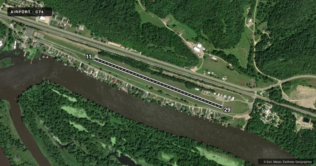
Runways & pattern
Full pagePattern entry · RWY 11
RIGHT TRAFFICRunway end performance
| End | TORA | TODA | ASDA | LDA | VGSI | Approach lights | Obstruction |
|---|---|---|---|---|---|---|---|
| 11 | — | — | — | — | — | — | 4', fence, 200' from thr, 110' R of cntrln, slope 0 |
| 29 | — | — | — | — | — | — | 15', road, 200' from thr, 90' R of cntrln, slope 0 |
Declared distances in feet. TORA = takeoff run available, TODA = takeoff distance, ASDA = accelerate-stop, LDA = landing distance.
Airport sketch
Runways drawn to scale from FAA survey coordinates, rendered over satellite imagery. Not for navigation.
Approaches & charts
Services on the field
Fuel grades, oxygen, maintenance, ramp storage and lighting — as declared to the FAA by the airport operator.
Fuel & services
- Fuel
- Not available
- Oxygen (bottled)
- Not available
- Oxygen (bulk)
- Not available
- Airframe repair
- Not available
- Power plant repair
- Not available
Ramp & ground
- Transient storage
- Tie-down
- Landing fee
- No fee published
- Customs
- Not available
- Lighting schedule
- SS-SR
- Wind indicator
- Lighted
- Segmented circle
- No
Fuel & FBOs
Cheapest 100LL and Jet A on the field and nearby. Always confirm with the FBO before taxi.
Airport notes
Surface conditions, obstructions, local procedures, lighting outages and other notes published with each FAA cycle.
General notes
- 1350 FT X 20 FT INLINE TWY WEST OF RWY 11.
- 270 FT BLUFF PARALLELS RWY 800 FT N.
- FOR WINTER COND & SNOW REMOVAL CALL AMGR.
- FOR CD CTC CHICAGO ARTCC AT 630-906-8921.
Runway surface & condition
- 11/29THR LGTS EMIT GREEN ONLY.
Approach & departure obstructions
- 114 FT FENCE 0-200 FT FM RWY END 100 FT R.
- 294 FT FENCE 0-200 FT FM RWY END 75 FT L & 15 FT ROAD 0-200 FT FM RWY END 100 FT L.
- 11CTLNG OBSTN EXCEEDS A 45 DEG SLP.
- 29APCH RATIO 20:1 TO DSPLCD THR.
Other notes
- EST PRIOR TO 1959.
- 11/29NMRS CRACKS AND VEGETATION GROWING ENTIRE PAVEMENT LEN.
VFR map & nearby airports
VFR sectional. Tap any ICAO chip to open that airport.
Key facts · C74
Answer card- ICAO
- C74
- Name
- CASSVILLE MUNI
- Location
- CASSVILLE, WISCONSIN
- Elevation
- 627 ft MSL
- Traffic pattern altitude
- 1,627 ft MSL (1,000 AGL)
- Control tower
- Non-towered (use CTAF)
- Total runways
- 1
- Longest runway
- 11/29 · 3,000 ft
- Published ILS approaches
- 0
- Published frequencies
- 1
- Magnetic variation
- 2°
- Current flight rules
- VFR
- Current wind
- 000° at 0 kt
- Favored runway now
- –
CASSVILLE MUNI sits in Cassville, Wisconsin. Field elevation is 627 ft MSL. The airport has one runway. Runway 11/29 is 3,000 ft long with an asphalt surface. There is no control tower. CTAF is 122.9. No ILS approaches are published here.
Pattern altitude is not published. Use the standard 1,000 ft AGL pattern unless the current Chart Supplement or airport operator says otherwise. The field has no on-field FBOs listed, so plan ahead and confirm services before you go. For winter conditions and snow removal, call the airport manager. The runway has published lighting notes. The threshold lights emit green only.
This is a small, older field with some operational details worth checking before arrival. The airport was established before 1959. There are cracks and vegetation along the pavement length. There is also a 1350 ft by 20 ft inline taxiway west of runway 11. Obstructions are close to both runway ends. Runway 11 has a fence near the departure end. Runway 29 has a fence and a road near the departure end. A bluff also parallels the runway to the north. If you are planning a first trip in, review the current Chart Supplement and brief the runway environment before descent.