METAR & TAF KFEP
Current METAR
Observed 03:35Z
KFEP 270335Z AUTO 00000KT 4SM CLR 27/26 A2986 RMK AO2 T02650256
- Wind
- 000° @ 0 kt
- Visibility
- 4 SM
- Temp / Dew
- 27°C / 26°C
- Altimeter
- 29.86 inHg
- Clouds
- CLR
- Density alt
- 2,580 ft
- Ceiling
- Unlimited
- Rules
- MVFR
Airport info & contacts
Manager on record, flight service, ARTCC, attendance schedule and pattern altitude — published by the FAA and refreshed every 28 days.
Location
- From city
- 3 NM SE
- VFR sectional
- CHICAGO
- Pattern altitude
- 400 ft AGL · 1,259 ft MSL
- ARTCC
- ZAU · CHICAGO
- NOTAM facility
- FEP (NOTAM-D)
Airport manager
- Name
- JEFFREY MODICA
- Phone
- 815-232-1078
- Address
- 1255 E AIRPORT ROAD, FREEPORT IL 61032
Flight service · Hours
- FSS IKK
- KANKAKEE1-800-WX-BRIEF
- Attendance
- MON-FRI · 0830-1630
- SAT · 0900-1600
Frequencies
Tap any row to copy the frequency to your clipboard.
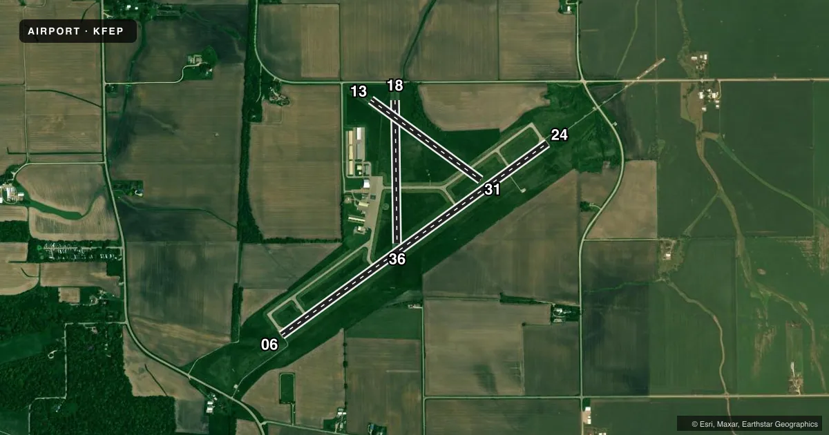
Runways & pattern
Full pagePattern entry · RWY 06
LEFT TRAFFIC| Runway | Heading (°M) | Length | Surface | Traffic |
|---|---|---|---|---|
| 06/24 | 54° / 234° | 5,504 ft | ASPH | Standard L |
| 18/36 | 179° / 359° | 2,404 ft | TURF | Standard L |
| 13/31 | 126° / 306° | 2,285 ft | TURF | Standard L |
Runway end performance
| End | TORA | TODA | ASDA | LDA | VGSI | Approach lights | Obstruction |
|---|---|---|---|---|---|---|---|
| 06 | — | — | — | — | PAPI 4-box left(2.8°) | — | 52', tree, 2118' from thr, 243' R of cntrln, slope 34 |
| 24 | — | — | — | — | PAPI 4-box left(2.8°) | MALSR | — |
Declared distances in feet. TORA = takeoff run available, TODA = takeoff distance, ASDA = accelerate-stop, LDA = landing distance.
Airport sketch
Runways drawn to scale from FAA survey coordinates, rendered over satellite imagery. Not for navigation.
Approaches & charts
ILS · 1
Services on the field
Fuel grades, oxygen, maintenance, ramp storage and lighting — as declared to the FAA by the airport operator.
Fuel & services
- Fuel
- 100LLA
- Oxygen (bottled)
- Not available
- Oxygen (bulk)
- Not available
- Airframe repair
- Major
- Power plant repair
- Major
- Other services
- INSTR,RNTL
Ramp & ground
- Transient storage
- Tie-down
- Hangar
- Landing fee
- No fee published
- Customs
- Not available
- Lighting schedule
- SEE RMK
- Beacon schedule
- SS-SR
- Beacon
- White / Green (civil land)(WG)
- Wind indicator
- Lighted
- Segmented circle
- Yes
Fuel & FBOs
Cheapest 100LL and Jet A on the field and nearby. Always confirm with the FBO before taxi.
Airport notes
Surface conditions, obstructions, local procedures, lighting outages and other notes published with each FAA cycle.
General notes
- FOR CD CTC CHICAGO ARTCC AT 630-906-8921.
Lighting notes
- MIRL RY 06/24 & TWY LGTS PRESET ON LOW INTST SS-SR; TO INCR INTST & ACTVT MALSR RY 24 - CTAF. PAPI RYS 06 & 24 OPERATE CONTINUOUSLY.
Fuel notes
- 100LL100 LL AVAILABLE 24HR SELF SERVICE
Approach & departure obstructions
- 1313/31 THLDS MKD WITH IN-GROUND CONC MARKERS.
- 1818/36 THLDS MKD WITH IN-GROUND CONC MARKERS.
Other notes
- TPA: 400 FT AGL ULTRALIGHTS, 800 FT AGL PISTON ACFT.
VFR map & nearby airports
VFR sectional. Tap any ICAO chip to open that airport.
Key facts · KFEP
Answer card- ICAO
- KFEP
- Name
- ALBERTUS
- Location
- FREEPORT, ILLINOIS
- Elevation
- 859 ft MSL
- Traffic pattern altitude
- 1,259 ft MSL (400 AGL)
- Control tower
- Non-towered (use CTAF)
- Total runways
- 3
- Longest runway
- 06/24 · 5,504 ft
- Published ILS approaches
- 1
- Published frequencies
- 5
- Magnetic variation
- 0°
- Current flight rules
- MVFR
- Current wind
- 000° at 0 kt
- Favored runway now
- –
Albertus Airport is in Freeport, Illinois. The field elevation is 859 ft MSL. KFEP has three runways. The longest is 06/24 at 5,504 ft, with turf runways 18/36 at 2,404 ft and 13/31 at 2,285 ft. There is no control tower, so plan to use CTAF 122.8 for local traffic calls. The airport has one ILS approach to runway 24. Pattern altitude is 400 ft AGL for ultralights. Pattern altitude is 800 ft AGL for piston aircraft, which puts the piston pattern at 1,659 ft MSL.
Freeport Aviation is on the field. It carries 100LL and Jet A. 100LL is also available 24 hours by self-service. Runway 06/24 has medium intensity lights. They are preset low from sunset to sunrise. Use CTAF to raise intensity and to activate the MALSR for runway 24. PAPI is available on runways 06 and 24 and it runs continuously. Runway 18/36 and 13/31 have in-ground concrete touchdown zone markers.
This is a non-towered field with published Rockford approach and departure frequencies. For clearance delivery, contact Chicago ARTCC. The airport sits in a relatively flat part of northwest Illinois. The main planning items are runway selection, traffic calls and the lighting setup on 06/24. Check the current FAA Chart Supplement for any published noise or curfew restrictions before flying in.