METAR & TAF C55
C55 does not publish a METAR.
Showing the nearest reporting station: KFEP (ALBERTUS) · 15.1 NM away. Conditions at C55 may differ.
METAR · KFEP
Observed 11:15Z
KFEP 271115Z AUTO 00000KT 1/4SM OVC002 26/25 A2985 RMK AO2 T02600252
- Wind
- 000° @ 0 kt
- Visibility
- 0.25 SM
- Temp / Dew
- 26°C / 25°C
- Altimeter
- 29.85 inHg
- Clouds
- OVC
- Density alt
- 2,559 ft
- Ceiling
- 200 ft AGL
- Rules
- LIFR
Airport info & contacts
Manager on record, flight service, ARTCC, attendance schedule and pattern altitude — published by the FAA and refreshed every 28 days.
Location
- From city
- 2 NM SE
- VFR sectional
- CHICAGO
- Pattern altitude
- 400 ft AGL · 1,329 ft MSL
- ARTCC
- ZAU · CHICAGO
- NOTAM facility
- IKK (NOTAM-D)
Airport manager
- Name
- TJ GRADEN
- Phone
- 815-275-4907
- Address
- PO BOX 61, MT MORRIS IL 61054
Flight service · Hours
- FSS IKK
- KANKAKEE1-800-WX-BRIEF
- Attendance
- UNATTENDED
Frequencies
Tap any row to copy the frequency to your clipboard.
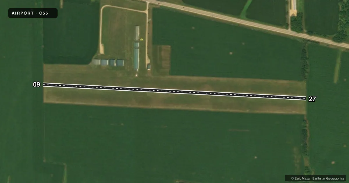
Runways & pattern
Full pagePattern entry · RWY 09
LEFT TRAFFICAirport sketch
Runways drawn to scale from FAA survey coordinates, rendered over satellite imagery. Not for navigation.
Approaches & charts
Services on the field
Fuel grades, oxygen, maintenance, ramp storage and lighting — as declared to the FAA by the airport operator.
Fuel & services
- Fuel
- Not available
- Other services
- INSTR,RNTL
Ramp & ground
- Transient storage
- Tie-down
- Landing fee
- No fee published
- Lighting schedule
- SEE RMK
- Beacon schedule
- SEE RMK
- Beacon
- White / Green (civil land)(WG)
- Wind indicator
- Yes
- Segmented circle
- No
Fuel & FBOs
Cheapest 100LL and Jet A on the field and nearby. Always confirm with the FBO before taxi.
Airport notes
Surface conditions, obstructions, local procedures, lighting outages and other notes published with each FAA cycle.
General notes
- RWY 9/27 NOT PLOWED DURING WINTER MONTHS; USE AT OWN RISK
- FOR CD CTC CHICAGO ARTCC AT 630-906-8921.
Lighting notes
- ACTVT ROTG BCN - CTAF.
- ACTVT NSTD LIRL RY 09/27 - CTAF.
Runway surface & condition
- 09/27RWY 09/27 NSTD LIRL DUE TO SPACING; INTENSITY & NON-FRANGIBLE - ORANGE CONES ADJACENT TO LIGHTS.
Approach & departure obstructions
- 09+10 FT CORN MAY BE ON RY ENDS DURING GROWING SEASON.
Other notes
- PRVD ALL OBS PENTG RWY APP SLOPE SFCS ARE RMVD, THRS CLRLY MKD TO PRVD MIN OF 20:1 APP CLRNC OVR ALL OBS & SUF RMNG USBL RWY LENGTH AVBL TO PRMT SAFE LNDG/TKOF BY TYPE ACFT USING RWYS.
- TPA: 400 FT AGL ULTRALIGHTS, 800 FT AGL SNGL ENG.
- MANAGEREMAIL ADDRESS: GRADENAIR1978@GMAIL.COM (ALL LOWER CASE)
VFR map & nearby airports
VFR sectional. Tap any ICAO chip to open that airport.
Key facts · C55
Answer card- ICAO
- C55
- Name
- OGLE COUNTY
- Location
- MOUNT MORRIS, ILLINOIS
- Elevation
- 929 ft MSL
- Traffic pattern altitude
- 1,329 ft MSL (400 AGL)
- Control tower
- Non-towered (use CTAF)
- Total runways
- 1
- Longest runway
- 09/27 · 2,640 ft
- Published ILS approaches
- 0
- Published frequencies
- 1
- Magnetic variation
- 0°
- Current flight rules
- LIFR
- Current wind
- 000° at 0 kt
- Favored runway now
- –
Ogle County Airport sits near Mount Morris, Illinois. Field elevation is 929 ft MSL. The airport has one runway. Runway 09/27 is 2,640 ft of turf, which is the longest runway on the field. There is no control tower. CTAF is 122.9.
No ILS approaches are published here. The pattern altitude is 400 ft AGL for ultralights. That is 1,329 ft MSL. Single engine aircraft use 800 ft AGL. That is 1,729 ft MSL. The runway has nonstandard low intensity lights. They are activated on the CTAF frequency. The rotating beacon is also activated on CTAF.
There are no on-field FBOs listed. Plan on self-sufficiency and verify current services with the airport operator before arrival. Published remarks also say winter use of Runway 09/27 is at your own risk because it is not plowed. During growing season, corn up to 10 ft may be present near the runway ends. The field also notes that clearance delivery is handled through Chicago ARTCC. For a first-time arrival, the big items are the turf surface, the seasonal obstructions and the low-intensity lighting setup on 09/27.