METAR & TAF C73
C73 does not publish a METAR.
Showing the nearest reporting station: KSQI (WHITESIDE COUNTY/JOS H BITTORF FLD) · 11.7 NM away. Conditions at C73 may differ.
METAR · KSQI
Observed 12:04Z
KSQI 271204Z AUTO 00000KT 1SM BR OVC001 27/27 A2984 RMK AO2 PWINO RVRNO $
- Wind
- 000° @ 0 kt
- Visibility
- 1 SM
- Temp / Dew
- 27°C / 27°C
- Altimeter
- 29.84 inHg
- Clouds
- OVC
- Density alt
- 2,513 ft
- Ceiling
- 100 ft AGL
- Rules
- LIFR
Airport info & contacts
Manager on record, flight service, ARTCC, attendance schedule and pattern altitude — published by the FAA and refreshed every 28 days.
Location
- From city
- 1 NM E
- VFR sectional
- CHICAGO
- ARTCC
- ZAU · CHICAGO
- NOTAM facility
- IKK (NOTAM-D)
Airport manager
- Name
- TYLER VENIER
- Phone
- 815-973-4200
- Address
- 1650 FRANKLIN GROVE RD, DIXON IL 61021
Flight service · Hours
- FSS IKK
- KANKAKEE1-800-WX-BRIEF
- Attendance
- MON-FRI · 0800-1700
- SAT · 0800-1200
- SUN · ON CALL
Frequencies
Tap any row to copy the frequency to your clipboard.
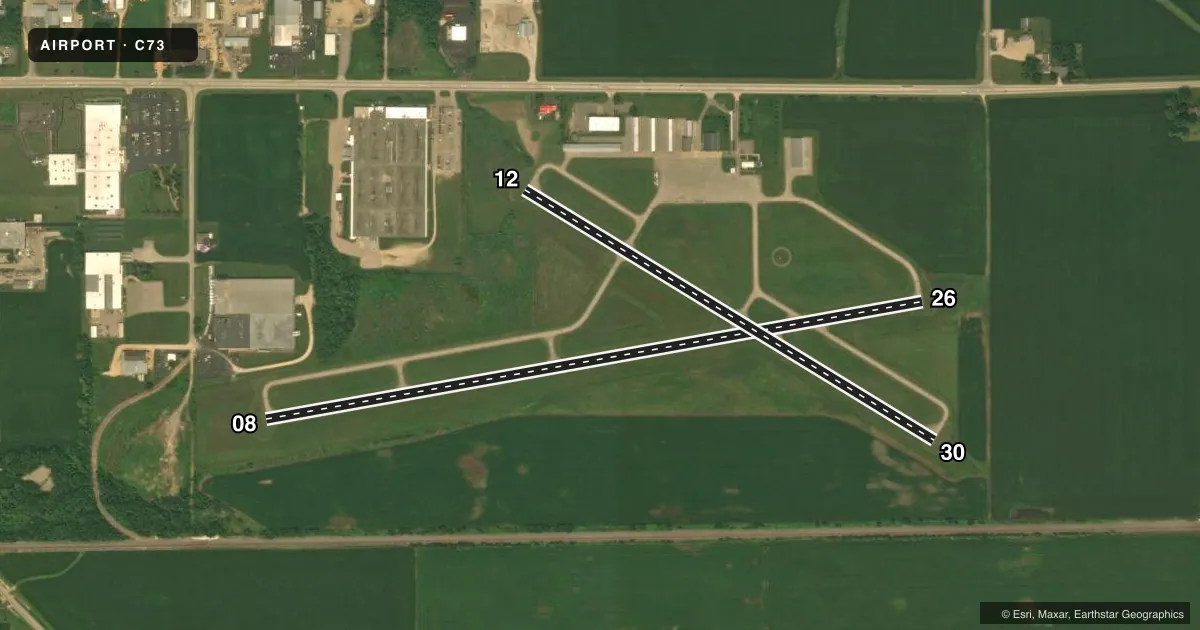
Runways & pattern
Full pagePattern entry · RWY 08
LEFT TRAFFIC| Runway | Heading (°M) | Length | Surface | Traffic |
|---|---|---|---|---|
| 08/26 | 78° / 258° | 3,897 ft | ASPH | Standard L |
| 12/30 | 119° / 299° | 2,803 ft | ASPH | Standard L |
Runway end performance
| End | TORA | TODA | ASDA | LDA | VGSI | Approach lights | Obstruction |
|---|---|---|---|---|---|---|---|
| 26 | — | — | — | — | PAPI 4-box left(3°) | — | — |
Declared distances in feet. TORA = takeoff run available, TODA = takeoff distance, ASDA = accelerate-stop, LDA = landing distance.
Airport sketch
Runways drawn to scale from FAA survey coordinates, rendered over satellite imagery. Not for navigation.
Approaches & charts
Services on the field
Fuel grades, oxygen, maintenance, ramp storage and lighting — as declared to the FAA by the airport operator.
Fuel & services
- Fuel
- 100LL
- Oxygen (bottled)
- Not available
- Oxygen (bulk)
- Not available
- Airframe repair
- Major
- Power plant repair
- Major
- Other services
- INSTR
Ramp & ground
- Transient storage
- Tie-down
- Hangar
- Landing fee
- No fee published
- Customs
- Not available
- Lighting schedule
- SEE RMK
- Beacon schedule
- SS-SR
- Beacon
- White / Green (civil land)(WG)
- Wind indicator
- Lighted
- Segmented circle
- Yes
Fuel & FBOs
Cheapest 100LL and Jet A on the field and nearby. Always confirm with the FBO before taxi.
Airport notes
Surface conditions, obstructions, local procedures, lighting outages and other notes published with each FAA cycle.
General notes
- HELIPAD PARKING DESIGNATION LOCATED AT NE CORNER OF RAMP/APRON AREA.
- FOR CD CTC CHICAGO ARTCC AT 630-906-8921.
Lighting notes
- MIRL RY 12/30 PRESET ON LOW INTST SS-SR; TO INCR INTST & ACTVT MIRL RY 08/26, REIL RY 08, PAPI RY 26 - CTAF.
Fuel notes
- 100LLSELF FUELING AVBL 24 HRS.
Other notes
- THIS AIRPORT HAS BEEN SURVEYED BY THE NATIONAL GEODETIC SURVEY.
- 1FOR ATTENDANT CALL 815-667-0161 OR 815-440-6557. ADM BLDG ACCESS IS 24 HRS FOR RESTROOM.
- MANAGEREMAIL ADDRESS: TYLER.VENIER@DISCOVERDIXON.ORG (ALL LOWER CASE)
- MANAGER815-440-6186 MANAGER CELL NUMBER
VFR map & nearby airports
VFR sectional. Tap any ICAO chip to open that airport.
Key facts · C73
Answer card- ICAO
- C73
- Name
- DIXON MUNI-CHARLES R WALGREEN FLD
- Location
- DIXON, ILLINOIS
- Elevation
- 785 ft MSL
- Traffic pattern altitude
- 1,785 ft MSL (1,000 AGL)
- Control tower
- Non-towered (use CTAF)
- Total runways
- 2
- Longest runway
- 08/26 · 3,897 ft
- Published ILS approaches
- 0
- Published frequencies
- 4
- Magnetic variation
- 2°
- Current flight rules
- LIFR
- Current wind
- 000° at 0 kt
- Favored runway now
- –
Dixon Muni-Charles R Walgreen Fld is in Dixon, Illinois. Field elevation is 785 ft MSL. The airport has two asphalt runways. The longest is 3,897 ft on runway 08/26. Runway 12/30 is 2,803 ft. There is no control tower. No ILS approaches are published here.
Pattern altitude is not published. Use 1,000 ft AGL for light piston traffic unless the current FAA Chart Supplement says otherwise. That puts the standard pattern at 1,785 ft MSL based on the field elevation. Verify the local pattern before you go. CTAF and UNICOM are both 123.05. Rockford approach and departure are on 126.0 and 327.0 if you need them.
Dixon Municipal Airport is the on-field FBO. It carries 100LL. Self-fueling is available 24 hours. The published remarks also note medium intensity runway lights on 12/30. They are preset low from sunset to sunrise. Use CTAF to raise intensity on 08/26. That also activates the runway end identifier lights on 08 and the PAPI on 26. For a first-time arrival, the big items are the non-towered pattern, the published lighting setup and the fact that this field sits in a flat Illinois setting with no ILS published. Check the current FAA Chart Supplement for any noise or curfew restrictions before flying in.