METAR & TAF 3H5
3H5 does not publish a METAR.
Showing the nearest reporting station: KCWI (CLINTON MUNI) · 14.3 NM away. Conditions at 3H5 may differ.
METAR · KCWI
Observed 06:10Z
KCWI 270610Z AUTO 16005KT 1 1/4SM BR BKN002 26/26 A2984 RMK AO2
- Wind
- 160° @ 5 kt
- Visibility
- 0.25 SM
- Temp / Dew
- 26°C / 26°C
- Altimeter
- 29.84 inHg
- Clouds
- BKN
- Density alt
- 2,163 ft
- Ceiling
- 200 ft AGL
- Rules
- LIFR
Airport info & contacts
Manager on record, flight service, ARTCC, attendance schedule and pattern altitude — published by the FAA and refreshed every 28 days.
Location
- From city
- 1 NM N
- VFR sectional
- CHICAGO
- ARTCC
- ZAU · CHICAGO
- NOTAM facility
- IKK (NOTAM-D)
Airport manager
- Name
- JAMES E ROBINSON
- Phone
- (309) 230-0944
- Address
- 8689 STAR RD, ERIE IL 61250
Flight service · Hours
- FSS IKK
- KANKAKEE1-800-WX-BRIEF
- Attendance
- MON-FRI · SR-SS
Frequencies
Tap any row to copy the frequency to your clipboard.
Runways & pattern
Full pagePattern entry · RWY 18U
LEFT TRAFFICRunway end performance
| End | TORA | TODA | ASDA | LDA | VGSI | Approach lights | Obstruction |
|---|---|---|---|---|---|---|---|
| 18U | — | — | — | — | — | — | 68', trees, 720' from thr, 50' R of cntrln, slope 10 |
Declared distances in feet. TORA = takeoff run available, TODA = takeoff distance, ASDA = accelerate-stop, LDA = landing distance.
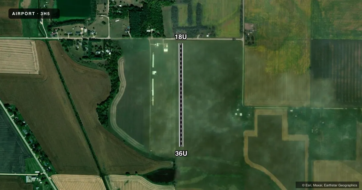
Airport sketch
Runways drawn to scale from FAA survey coordinates, rendered over satellite imagery. Not for navigation.
Approaches & charts
Services on the field
Fuel grades, oxygen, maintenance, ramp storage and lighting — as declared to the FAA by the airport operator.
Fuel & services
- Fuel
- Not available
- Airframe repair
- Not available
- Power plant repair
- Not available
- Other services
- INSTR,SALES
Ramp & ground
- Transient storage
- Tie-down
- Landing fee
- No fee published
- Wind indicator
- Yes
- Segmented circle
- No
Fuel & FBOs
Cheapest 100LL and Jet A on the field and nearby. Always confirm with the FBO before taxi.
Airport notes
Surface conditions, obstructions, local procedures, lighting outages and other notes published with each FAA cycle.
General notes
- RC MODEL ACFT ACTIVITY WEST OF RY 36 WED EVES, WX PERMITTING.
- FOR CD CTC CHICAGO ARTCC AT 630-906-8921.
Approach & departure obstructions
- 18URY 18U/36U THLDS MKD WITH L-SHAPED WHITE GRAVEL.
VFR map & nearby airports
VFR sectional. Tap any ICAO chip to open that airport.
Key facts · 3H5
Answer card- ICAO
- 3H5
- Name
- ERIE AIR PARK
- Location
- ERIE, ILLINOIS
- Elevation
- 600 ft MSL
- Traffic pattern altitude
- 1,600 ft MSL (1,000 AGL)
- Control tower
- Non-towered (use CTAF)
- Total runways
- 1
- Longest runway
- 18U/36U · 2,000 ft
- Published ILS approaches
- 0
- Published frequencies
- 0
- Magnetic variation
- 1°
- Current flight rules
- LIFR
- Current wind
- 160° at 5 kt
- Favored runway now
- RWY 18U
Erie Air Park is in Erie, Illinois. The field elevation is 600 ft MSL. It has one runway, 18U/36U, at 2,000 ft on turf. No tower is published here. No ILS approaches are published. The pattern altitude is not published, so use the standard 1,000 ft AGL for light piston operations unless the current FAA Chart Supplement says otherwise.
The runway thresholds are marked with L-shaped white gravel. That helps with runway identification on the turf strip. Radio-controlled model aircraft activity occurs west of runway 36 on Wednesday evenings, weather permitting. Plan around that if you are arriving or departing then. For clearance delivery, contact Chicago ARTCC at 630-906-8921.
This is a small non-towered field, so a good radio scan and a careful look at the turf condition matter. There are no on-field FBOs listed in the facts. Verify fuel and local services with the airport operator or the field directly before you go. Check the current FAA Chart Supplement for any published noise or curfew restrictions before flying into the field.