METAR & TAF 3G8
3G8 does not publish a METAR.
Showing the nearest reporting station: KMLI (QUAD CITIES INTL) · 17.9 NM away. Conditions at 3G8 may differ.
METAR · KMLI
Observed 02:52Z
KMLI 270252Z 19007KT 10SM CLR 28/27 A2981 RMK AO2 SLP089 T02830272 58009
- Wind
- 190° @ 7 kt
- Visibility
- 10 SM
- Temp / Dew
- 28°C / 27°C
- Altimeter
- 29.81 inHg
- Clouds
- CLR
- Density alt
- 2,496 ft
- Ceiling
- Unlimited
- Rules
- VFR
Airport info & contacts
Manager on record, flight service, ARTCC, attendance schedule and pattern altitude — published by the FAA and refreshed every 28 days.
Location
- From city
- 2 NM SE
- VFR sectional
- CHICAGO
- ARTCC
- ZAU · CHICAGO
- NOTAM facility
- IKK (NOTAM-D)
Airport manager
- Name
- SCOTT DARIAN
- Phone
- 309-314-6849
- Address
- 20026 EAST 1650 TH ST, 20035 1700 ST EAST, GENESEO IL 61254
Flight service · Hours
- FSS IKK
- KANKAKEE1-800-WX-BRIEF
- Attendance
- IREG
Frequencies
Tap any row to copy the frequency to your clipboard.
Runways & pattern
Full pagePattern entry · RWY 27
LEFT TRAFFICRunway end performance
| End | TORA | TODA | ASDA | LDA | VGSI | Approach lights | Obstruction |
|---|---|---|---|---|---|---|---|
| 09 | — | — | — | — | — | — | 12', road, 0' from thr, 0' R of cntrln, slope 0 |
| 27 | — | — | — | — | — | — | 15', road, 0' from thr, 0' R of cntrln, slope 0 |
Declared distances in feet. TORA = takeoff run available, TODA = takeoff distance, ASDA = accelerate-stop, LDA = landing distance.
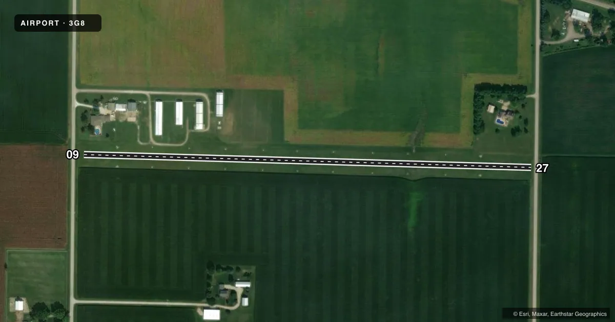
Airport sketch
Runways drawn to scale from FAA survey coordinates, rendered over satellite imagery. Not for navigation.
Approaches & charts
Services on the field
Fuel grades, oxygen, maintenance, ramp storage and lighting — as declared to the FAA by the airport operator.
Fuel & services
- Fuel
- Not available
- Other services
- INSTR,PAJA
Ramp & ground
- Transient storage
- Tie-down
- Landing fee
- No fee published
- Lighting schedule
- SS-SR
- Wind indicator
- Yes
- Segmented circle
- No
Fuel & FBOs
Cheapest 100LL and Jet A on the field and nearby. Always confirm with the FBO before taxi.
Airport notes
Surface conditions, obstructions, local procedures, lighting outages and other notes published with each FAA cycle.
General notes
- PARACHUTE ACTIVITY ON & INVOF ARPT.
- OBSTN FENCE 30 FT NORTH APCH END RY 09 (6 FT AGL) NOT LGTD.
- FOR CD CTC CHICAGO ARTCC AT 630-906-8921.
Runway surface & condition
- 09/27NSTD LIRL; NSTD SPACING & INTST.
Approach & departure obstructions
- 0909/27 DSPLCD THLDS MKD WITH A 10 FT STRIP OF GRAVEL OUTWARD FM BOTH SIDES OF RY.
- 09APCH RATIO 20:1 TO DSPLCD THR.
- 27APCH RATIO 20:1 TO DSPLCD THLD.
- 09ROAD 3 FT BLO RY END.
Other notes
- THIS AIRPORT HAS BEEN SURVEYED BY THE NATIONAL GEODETIC SURVEY.
- OBSTNS IN RWY APP SLOPE SFC RMVD/LWRD, OR RWY THR DSPLCD & MKD TO PRVD 20:1 APP OVER OBSTNS.
- TSNT MUST SUPPLY OWN ROPES.
- MANAGEREMAIL ADDRESS: AIRPORT3G8@GMAIL.COM (ALL LOWER CASE)
- MANAGERCO-MANGER SCOTT DURIAN (309) 314-6849
VFR map & nearby airports
VFR sectional. Tap any ICAO chip to open that airport.
Key facts · 3G8
Answer card- ICAO
- 3G8
- Name
- GEN-AIRPARK
- Location
- GENESEO, ILLINOIS
- Elevation
- 645 ft MSL
- Traffic pattern altitude
- 1,645 ft MSL (1,000 AGL)
- Control tower
- Non-towered (use CTAF)
- Total runways
- 1
- Longest runway
- 09/27 · 2,568 ft
- Published ILS approaches
- 0
- Published frequencies
- 1
- Magnetic variation
- 1°
- Current flight rules
- VFR
- Current wind
- 190° at 7 kt
- Favored runway now
- RWY 27
GEN-AIRPARK sits in Geneseo, Illinois. Field elevation is 645 ft MSL. The airport has one runway. Runway 09/27 is 2,568 ft of turf, so plan for soft-field performance and check the surface before you go. There is no control tower. CTAF is 122.9.
No ILS approaches are published here. Pattern altitude is not published, so use the current Chart Supplement and local traffic calls to sort out the pattern before arrival. The published remarks also note parachute activity on and near the airport. That matters for both arrival planning and traffic scanning.
Runways 09 and 27 have displaced thresholds. The remarks also call out nonstandard low-intensity runway lights with nonstandard spacing and intensity. There is an obstruction fence 30 feet north of the approach end of runway 09. The approach slope for both ends is protected with a 20 to 1 surface to the displaced thresholds. A road is 3 feet below the runway end of runway 09.
No on-field FBOs are listed. Contact the airport operator directly or call the field on CTAF for current service details. For clearance delivery, Chicago ARTCC is listed in the remarks. This is a small non-towered turf field. A first-time pilot should brief the runway condition, the displaced thresholds and the parachute activity before coming in.