METAR & TAF KSQI
Current METAR
Observed 12:28Z
KSQI 271228Z AUTO VRB03KT 1SM BR OVC001 27/27 A2983 RMK AO2 PWINO RVRNO $
- Wind
- VAR @ 3 kt
- Visibility
- 1 SM
- Temp / Dew
- 27°C / 27°C
- Altimeter
- 29.83 inHg
- Clouds
- OVC
- Density alt
- 2,355 ft
- Ceiling
- 100 ft AGL
- Rules
- LIFR
Airport info & contacts
Manager on record, flight service, ARTCC, attendance schedule and pattern altitude — published by the FAA and refreshed every 28 days.
Location
- From city
- 2 NM S
- VFR sectional
- CHICAGO
- ARTCC
- ZAU · CHICAGO
- NOTAM facility
- SQI (NOTAM-D)
Airport manager
- Name
- DARIN HEFFELFINGER
- Phone
- (815) 213-7939
- Address
- 10950 HOOVER RD, ROCKFALLS IL 61071
Flight service · Hours
- FSS IKK
- KANKAKEE1-800-WX-BRIEF
- Attendance
- 0800-1700
Frequencies
Tap any row to copy the frequency to your clipboard.
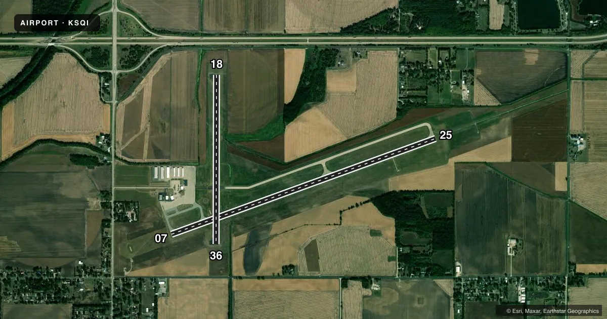
Runways & pattern
Full pagePattern entry · RWY 36
LEFT TRAFFIC| Runway | Heading (°M) | Length | Surface | Traffic |
|---|---|---|---|---|
| 07/25 | 68° / 248° | 6,499 ft | ASPH | Standard L |
| 18/36Favored | 178° / 358° | 3,900 ft | ASPH | Standard L |
Runway end performance
| End | TORA | TODA | ASDA | LDA | VGSI | Approach lights | Obstruction |
|---|---|---|---|---|---|---|---|
| 07 | — | — | — | — | PAPI 4-box left(3°) | — | — |
| 25 | — | — | — | — | — | MALSR | — |
Declared distances in feet. TORA = takeoff run available, TODA = takeoff distance, ASDA = accelerate-stop, LDA = landing distance.
Airport sketch
Runways drawn to scale from FAA survey coordinates, rendered over satellite imagery. Not for navigation.
Approaches & charts
ILS · 1
Services on the field
Fuel grades, oxygen, maintenance, ramp storage and lighting — as declared to the FAA by the airport operator.
Fuel & services
- Fuel
- 100LLA
- Airframe repair
- Major
- Power plant repair
- Major
- Other services
- AVNCS,INSTR,RNTL
Ramp & ground
- Transient storage
- Tie-down
- Hangar
- Landing fee
- No fee published
- Customs
- Not available
- Lighting schedule
- SEE RMK
- Beacon schedule
- SS-SR
- Beacon
- White / Green (civil land)(WG)
- Wind indicator
- Lighted
- Segmented circle
- Yes
Fuel & FBOs
Cheapest 100LL and Jet A on the field and nearby. Always confirm with the FBO before taxi.
Airport notes
Surface conditions, obstructions, local procedures, lighting outages and other notes published with each FAA cycle.
General notes
- RY 07 PREFERRED CALM WIND RY.
- TERMINAL BLDG CAN BE ACCESSED AFTER HOURS BY CIPHER LOCK WHICH HAS APPLICABLE INSTRUCTIONS
- OXY SVC UNAVBL.
- FOR CD CTC CHICAGO ARTCC AT 630-906-8921.
Lighting notes
- MIRL RY 18/36 PRESET ON LOW INTST; TO INCR INTST & ACTVT HIRL RY 07/25; MALSR RY 25 & REIL RYS 07, 18 & 36 - CTAF.
Fuel notes
- 100LL100LL AND JET A FUEL DISPENSER IS SELF SERVE WITH CREDIT CARD.
Other notes
- 1ARPT UNATNDD NEW YEARS; XMAS & THANKSGIVING.
VFR map & nearby airports
VFR sectional. Tap any ICAO chip to open that airport.
Key facts · KSQI
Answer card- ICAO
- KSQI
- Name
- WHITESIDE COUNTY/JOS H BITTORF FLD
- Location
- STERLING/ROCKFALLS, ILLINOIS
- Elevation
- 647.6 ft MSL
- Traffic pattern altitude
- 1,647.6 ft MSL (1,000 AGL)
- Control tower
- Non-towered (use CTAF)
- Total runways
- 2
- Longest runway
- 07/25 · 6,499 ft
- Published ILS approaches
- 1
- Published frequencies
- 5
- Magnetic variation
- 2°
- Current flight rules
- LIFR
- Current wind
- 000° at 3 kt
- Favored runway now
- RWY 36
Whiteside County/Jos H Bittorf Fld is in Sterling/Rock Falls, Illinois. The field elevation is 647.6 ft MSL. It has two asphalt runways. The longest is runway 07/25 at 6,499 ft. Runway 18/36 is 3,900 ft. There is no control tower, so plan to use CTAF and UNICOM 123.0 for local traffic. The published pattern altitude is not listed. For light piston traffic, use 1,000 ft AGL unless the current Chart Supplement says otherwise.
One ILS is published for runway 25. That makes the field useful in lower weather. You still need to brief the current approach and runway lighting setup before arrival. Runway 07 is the preferred calm wind runway. The lighting setup is a little specific here. Runway 18/36 medium intensity lights come on at low intensity by default. Use CTAF to raise intensity. Use it to activate the high intensity lights on runway 07/25. It also activates the MALSR for runway 25. The REILs on 07, 18 and 36 are on the same system.
Sauk Valley Aviation is on the field. It carries 100LL and Jet A. The fuel dispenser is self serve with credit card. The terminal building can be accessed after hours by cipher lock. Instructions are on site. Oxygen service is unavailable. Check the current Chart Supplement for any holiday or operating restrictions before you go.