METAR & TAF KCWI
Current METAR
Observed 09:56Z
KCWI 270956Z AUTO 16004KT 4SM BR CLR 25/24 A2982 RMK AO2 SLP094 T02500244
- Wind
- 160° @ 4 kt
- Visibility
- 4 SM
- Temp / Dew
- 25°C / 24°C
- Altimeter
- 29.82 inHg
- Clouds
- CLR
- Density alt
- 2,202 ft
- Ceiling
- Unlimited
- Rules
- MVFR
Airport info & contacts
Manager on record, flight service, ARTCC, attendance schedule and pattern altitude — published by the FAA and refreshed every 28 days.
Location
- From city
- 6 NM SW
- VFR sectional
- CHICAGO
- ARTCC
- ZAU · CHICAGO
- NOTAM facility
- CWI (NOTAM-D)
Airport manager
- Name
- MARLANA NASS
- Phone
- 563-242-3292
- Address
- 2000 S 60TH ST., CLINTON IA 52732
Flight service · Hours
- FSS FOD
- FORT DODGE1-800-WX-BRIEF
- Attendance
- MON-FRI · 0800-1700
Frequencies
Tap any row to copy the frequency to your clipboard.
Runways & pattern
Full pagePattern entry · RWY 14
LEFT TRAFFIC| Runway | Heading (°M) | Length | Surface | Traffic |
|---|---|---|---|---|
| 03/21 | 30° / 210° | 5,204 ft | CONC | Standard L |
| 14/32Favored | 144° / 325° | 4,201 ft | CONC | Standard L |
Runway end performance
| End | TORA | TODA | ASDA | LDA | VGSI | Approach lights | Obstruction |
|---|---|---|---|---|---|---|---|
| 03 | 5,204' | 5,204' | 5,204' | 5,204' | — | MALSR | — |
| 21 | 5,204' | 5,204' | 5,204' | 5,204' | VASI 4-box left(3°) | — | — |
| 14 | 4,200' | 4,200' | 4,200' | 4,200' | PAPI 4-box left(3°) | — | — |
| 32 | 4,200' | 4,200' | 4,200' | 4,200' | PAPI 4-box left(3°) | — | — |
Declared distances in feet. TORA = takeoff run available, TODA = takeoff distance, ASDA = accelerate-stop, LDA = landing distance.
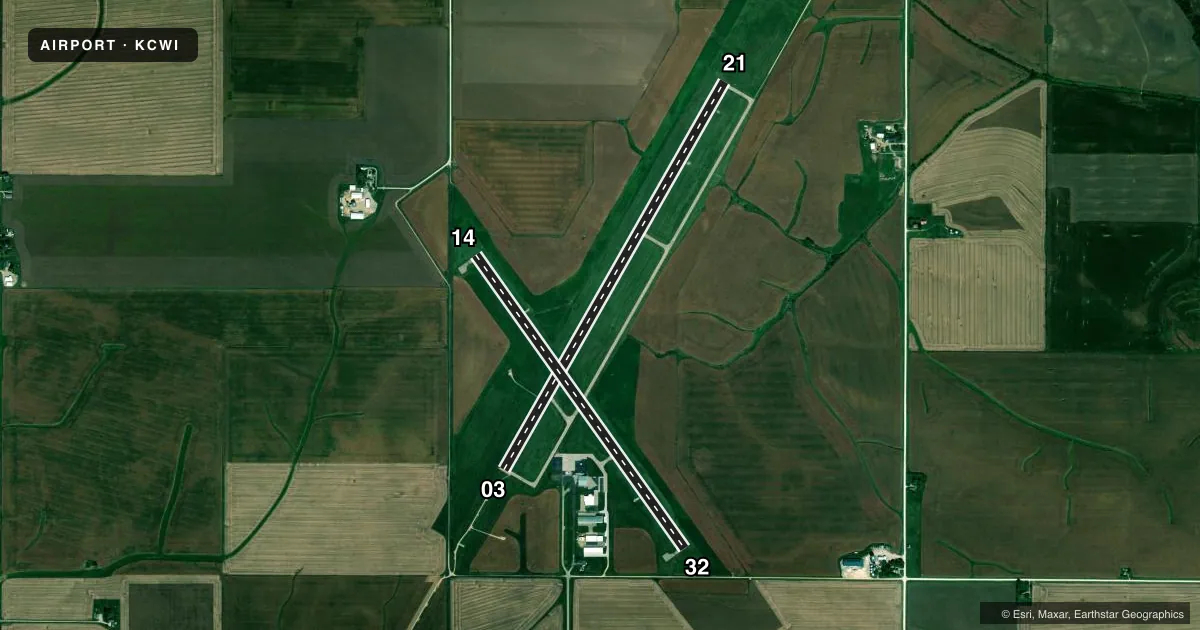
Airport sketch
Runways drawn to scale from FAA survey coordinates, rendered over satellite imagery. Not for navigation.
Approaches & charts
ILS · 1
Services on the field
Fuel grades, oxygen, maintenance, ramp storage and lighting — as declared to the FAA by the airport operator.
Fuel & services
- Fuel
- 100LLA
- Oxygen (bottled)
- Low pressure
- Other services
- CHTR,INSTR,RNTL
Ramp & ground
- Transient storage
- Tie-down
- Hangar
- Landing fee
- No fee published
- Customs
- Not available
- Lighting schedule
- SEE RMK
- Beacon schedule
- SS-SR
- Beacon
- White / Green (civil land)(WG)
- Wind indicator
- Lighted
- Segmented circle
- No
Fuel & FBOs
Cheapest 100LL and Jet A on the field and nearby. Always confirm with the FBO before taxi.
Airport notes
Surface conditions, obstructions, local procedures, lighting outages and other notes published with each FAA cycle.
General notes
- FOR CD CTC CHICAGO ARTCC AT 630-906-8921.
Lighting notes
- ACTVT MALSR RWY 03; REIL RWY 14 & 21; VASI RWY 21; PAPI RWY 14 & 32; HIRL RWY 03/21; MIRL RWY 14/32 - CTAF.
Runway surface & condition
- 03/21RWY 03 CALM WIND RWY.
Other notes
- PRVDD APCH TO EACH RWY IS MAINTD FOR A MIN 34:1 OR 20:1 GS; WHICHEVER IS APPLICABLE; AND THE TRANSITIONAL SURFACE BE MAINTAINED FOR A 7:1 SLOPE.
VFR map & nearby airports
VFR sectional. Tap any ICAO chip to open that airport.
Key facts · KCWI
Answer card- ICAO
- KCWI
- Name
- CLINTON MUNI
- Location
- CLINTON, IOWA
- Elevation
- 707.7 ft MSL
- Traffic pattern altitude
- 1,707.7 ft MSL (1,000 AGL)
- Control tower
- Non-towered (use CTAF)
- Total runways
- 2
- Longest runway
- 03/21 · 5,204 ft
- Published ILS approaches
- 1
- Published frequencies
- 5
- Magnetic variation
- 0°
- Current flight rules
- MVFR
- Current wind
- 160° at 4 kt
- Favored runway now
- RWY 14
Clinton Muni is in Clinton, Iowa. The field elevation is 707.7 ft MSL. It has two concrete runways. Runway 03/21 is the longest at 5,204 ft. Runway 14/32 is 4,201 ft. There is no control tower, so plan to use CTAF 123.075 for airport traffic calls.
The airport has one ILS approach. It serves runway 03. Published remarks also note that runway 03 is the calm wind runway. Lighting is straightforward for night work. MALSR is on runway 03. High intensity lighting is available on runways 03 and 21. Medium intensity lighting is available on runways 14 and 32. REIL is available on runways 14 and 21. VASI is available on runway 21. PAPI is available on runways 14 and 32.
Pattern altitude is not published. Use standard 1,000 ft AGL for light piston operations unless the current Chart Supplement says otherwise. That puts the traffic pattern near 1,708 ft MSL based on the field elevation. Clinton Municipal Airport is the on-field FBO. It carries 100LL and Jet A. Call ahead at (563) 242-3292 for current service details. For IFR work, clearance delivery is handled through Chicago ARTCC at 630-906-8921. The airport sits in a flat river valley area. The main planning items are wind, runway selection and staying sharp on the ILS to 03 when the weather comes down.