METAR & TAF KOQW
KOQW does not publish a METAR.
Showing the nearest reporting station: KDBQ (DUBUQUE RGNL) · 21.1 NM away. Conditions at KOQW may differ.
METAR · KDBQ
Observed 12:53Z
KDBQ 271253Z 19008KT 7SM CLR 27/26 A2979 RMK AO2 LTG DSNT W SLP079 T02720261 $
- Wind
- 190° @ 8 kt
- Visibility
- 7 SM
- Temp / Dew
- 27°C / 26°C
- Altimeter
- 29.79 inHg
- Clouds
- CLR
- Density alt
- 2,560 ft
- Ceiling
- Unlimited
- Rules
- VFR
Airport info & contacts
Manager on record, flight service, ARTCC, attendance schedule and pattern altitude — published by the FAA and refreshed every 28 days.
Location
- From city
- 3 NM W
- VFR sectional
- CHICAGO
- ARTCC
- ZAU · CHICAGO
- NOTAM facility
- FOD (NOTAM-D)
Airport manager
- Name
- JON HOPSON
- Phone
- 563-212-0595
- Address
- 201 EAST PLEASANT STREET, MAQUOKETA IA 52060-9671
Flight service · Hours
- FSS FOD
- FORT DODGE1-800-WX-BRIEF
- Attendance
- Unattended
Frequencies
Tap any row to copy the frequency to your clipboard.
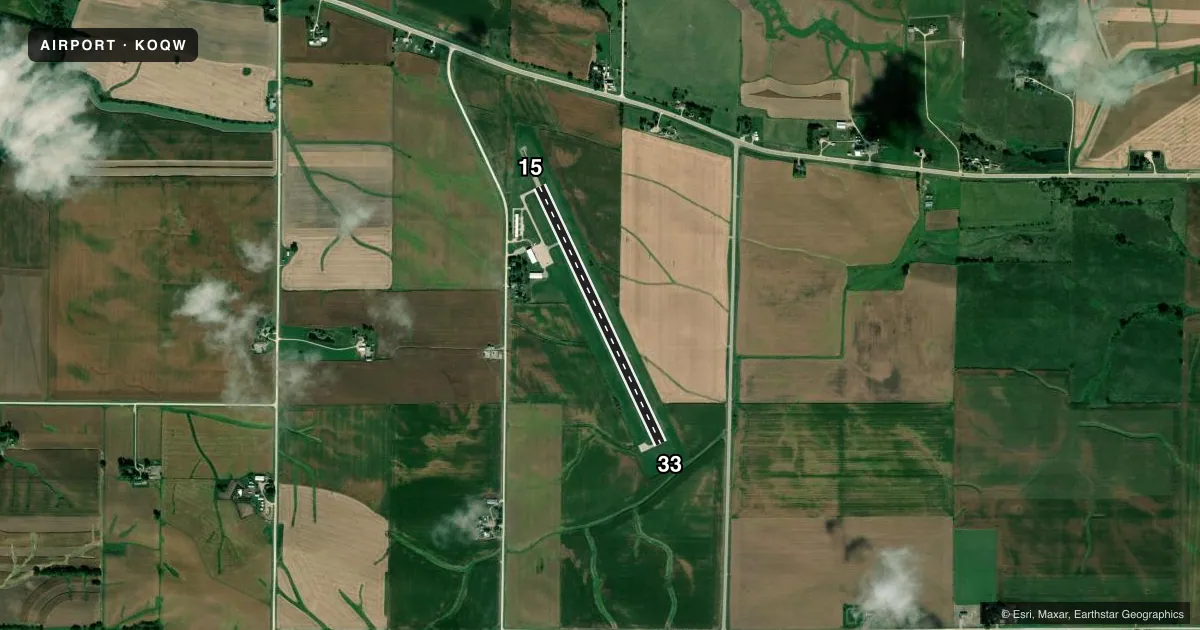
Runways & pattern
Full pagePattern entry · RWY 15
LEFT TRAFFICRunway end performance
| End | TORA | TODA | ASDA | LDA | VGSI | Approach lights | Obstruction |
|---|---|---|---|---|---|---|---|
| 15 | — | — | — | — | PAPI 2-box left(4°) | — | 68', trees, 1878' from thr, 20' R of cntrln, slope 24 |
| 33 | — | — | — | — | PAPI 2-box left(3°) | — | 115', tree, 2540' from thr, 298' R of cntrln, slope 20 |
Declared distances in feet. TORA = takeoff run available, TODA = takeoff distance, ASDA = accelerate-stop, LDA = landing distance.
Airport sketch
Runways drawn to scale from FAA survey coordinates, rendered over satellite imagery. Not for navigation.
Approaches & charts
Services on the field
Fuel grades, oxygen, maintenance, ramp storage and lighting — as declared to the FAA by the airport operator.
Fuel & services
- Fuel
- 100LL
- Oxygen (bottled)
- Not available
- Oxygen (bulk)
- Not available
- Airframe repair
- Not available
- Power plant repair
- Not available
- Other services
- CHTR,INSTR,RNTL
Ramp & ground
- Transient storage
- Tie-down
- Hangar
- Landing fee
- No fee published
- Lighting schedule
- SEE RMK
- Beacon schedule
- SS-SR
- Beacon
- White / Green (civil land)(WG)
- Wind indicator
- Lighted
- Segmented circle
- No
Fuel & FBOs
Cheapest 100LL and Jet A on the field and nearby. Always confirm with the FBO before taxi.
Airport notes
Surface conditions, obstructions, local procedures, lighting outages and other notes published with each FAA cycle.
General notes
- ULTRALIGHT ACTVTY ON & INVOF ARPT.
- RY 33 IS CALM WIND RY.
- FOR CD CTC CHICAGO ARTCC AT 630-906-8921.
Lighting notes
- ACTVT REIL RWY 15 & 33; PAPI RWYS 15 & 33; MIRL RWY 15/33 - CTAF.
Fuel notes
- 100LLSELF-SERVE FUEL AVBL 24 HR WITH CREDIT CARD.
Approach & departure obstructions
- 15RWY 15 PAPI UNUSBL BYD 8 DEG RIGHT OF CNTRLN.
- 33RWY 33 PAPI UNUSBL BYD 8 DEG RIGHT OF CNTRLN.
Other notes
- 1SVC AVBL AT 1-800-553-5283.
VFR map & nearby airports
VFR sectional. Tap any ICAO chip to open that airport.
Key facts · KOQW
Answer card- ICAO
- KOQW
- Name
- MAQUOKETA MUNI
- Location
- MAQUOKETA, IOWA
- Elevation
- 773.6 ft MSL
- Traffic pattern altitude
- 1,773.6 ft MSL (1,000 AGL)
- Control tower
- Non-towered (use CTAF)
- Total runways
- 1
- Longest runway
- 15/33 · 3,804 ft
- Published ILS approaches
- 0
- Published frequencies
- 2
- Magnetic variation
- 0°
- Current flight rules
- VFR
- Current wind
- 190° at 8 kt
- Favored runway now
- RWY 15
Maquoketa Muni is in Maquoketa, Iowa. Field elevation is 769.4 ft MSL. The airport has one runway. Runway 15/33 is 3,304 ft of concrete. There is no control tower, so use CTAF 122.725 for local traffic. No ILS approaches are published here.
Pattern altitude is not published. Use 1,000 ft AGL for light piston operations unless the current Chart Supplement says otherwise. Runway 33 is listed as the calm wind runway. Runway end identifier lights are available on 15 and 33. PAPI is also available on both ends. The runway lights are medium intensity and are controlled on CTAF. The published remarks also note that the runway 15 and 33 PAPIs are unusable beyond 8 degrees right of centerline.
Maquoketa Municipal Airport is the on-field FBO. It carries self-serve 100LL. Fuel is available 24 hours with a credit card. Ultralight activity is published in and near the airport, so keep your scan active in the pattern and on taxi. For clearance delivery, the published contact is Chicago ARTCC at 630-906-8921. Check the current Chart Supplement for any other local procedures before you go.