METAR & TAF KEZI
KEZI does not publish a METAR.
Showing the nearest reporting station: KGBG (HARREL W TIMMONS GALESBURG RGNL) · 26.5 NM away. Conditions at KEZI may differ.
METAR · KGBG
Observed 10:15Z
KGBG 271015Z AUTO 00000KT 10SM CLR 25/25 A2985 RMK AO2 P0068 T02540254
- Wind
- 000° @ 0 kt
- Visibility
- 10 SM
- Temp / Dew
- 25°C / 25°C
- Altimeter
- 29.85 inHg
- Clouds
- CLR
- Density alt
- 2,351 ft
- Ceiling
- Unlimited
- Rules
- VFR
Airport info & contacts
Manager on record, flight service, ARTCC, attendance schedule and pattern altitude — published by the FAA and refreshed every 28 days.
Location
- From city
- 3 NM SW
- VFR sectional
- CHICAGO
- Pattern altitude
- 400 ft AGL · 1,258 ft MSL
- ARTCC
- ZAU · CHICAGO
- NOTAM facility
- IKK (NOTAM-D)
Airport manager
- Name
- ROSS CARBIENER
- Phone
- 309-853-8671
- Address
- 3769 MIDLAND RD., KEWANEE IL 61443
Flight service · Hours
- FSS IKK
- KANKAKEE1-800-WX-BRIEF
- Attendance
- MON-FRI · 0800-1800
- SAT · 0900-1700
- SUN · 0900-1700
Frequencies
Tap any row to copy the frequency to your clipboard.
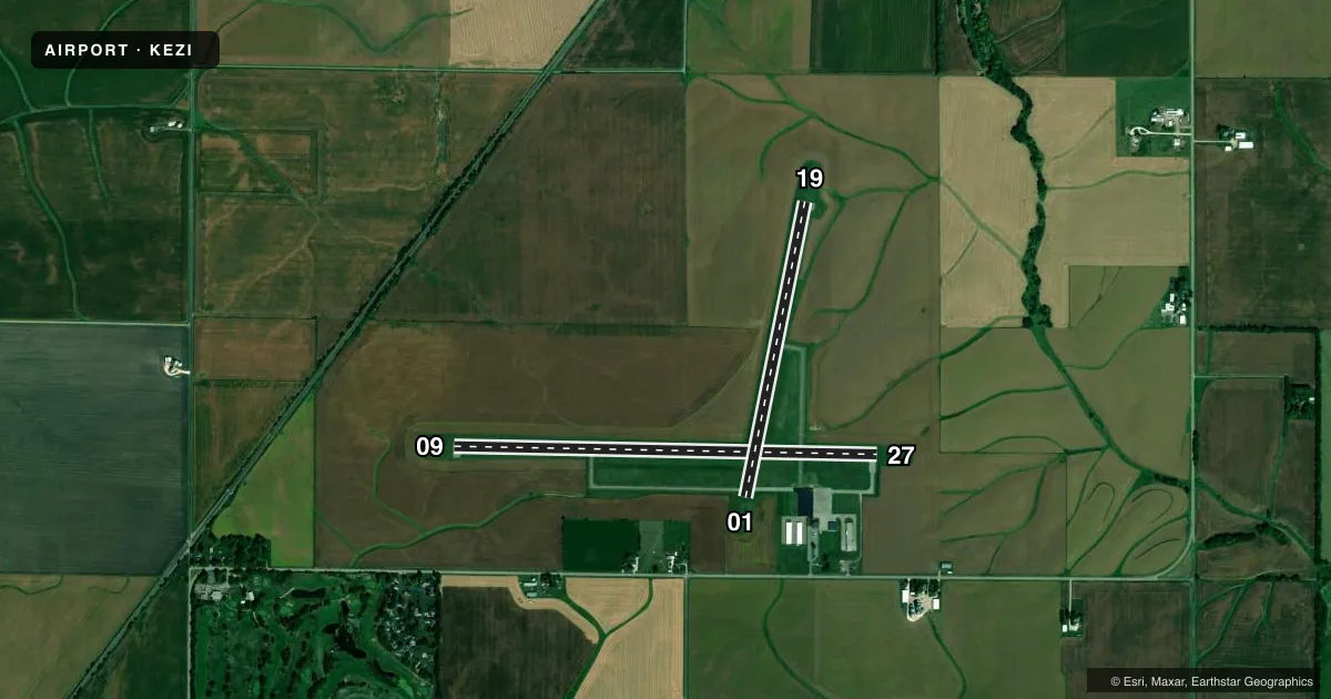
Runways & pattern
Full pagePattern entry · RWY 09
LEFT TRAFFIC| Runway | Heading (°M) | Length | Surface | Traffic |
|---|---|---|---|---|
| 09/27 | 89° / 269° | 4,500 ft | ASPH | Standard L |
| 01/19 | 9° / 189° | 3,200 ft | ASPH | Standard L |
Runway end performance
| End | TORA | TODA | ASDA | LDA | VGSI | Approach lights | Obstruction |
|---|---|---|---|---|---|---|---|
| 09 | — | — | — | — | PSIL(3.5°) | — | — |
| 27 | — | — | — | — | PSIL(3°) | — | — |
Declared distances in feet. TORA = takeoff run available, TODA = takeoff distance, ASDA = accelerate-stop, LDA = landing distance.
Airport sketch
Runways drawn to scale from FAA survey coordinates, rendered over satellite imagery. Not for navigation.
Approaches & charts
Services on the field
Fuel grades, oxygen, maintenance, ramp storage and lighting — as declared to the FAA by the airport operator.
Fuel & services
- Fuel
- 100LL
- Oxygen (bottled)
- Not available
- Oxygen (bulk)
- Not available
- Airframe repair
- Major
- Power plant repair
- Major
Ramp & ground
- Transient storage
- Tie-down
- Hangar
- Landing fee
- No fee published
- Customs
- Not available
- Lighting schedule
- SEE RMK
- Beacon schedule
- SS-SR
- Beacon
- White / Green (civil land)(WG)
- Wind indicator
- Lighted
- Segmented circle
- Yes
Fuel & FBOs
Cheapest 100LL and Jet A on the field and nearby. Always confirm with the FBO before taxi.
Airport notes
Surface conditions, obstructions, local procedures, lighting outages and other notes published with each FAA cycle.
General notes
- ULTRALIGHT ACTIVITY ON & INVOF ARPT.
- HOSPITAL HELIPORT 1.2 NM NORTHEAST OF ARPT.
- FOR CD CTC CHICAGO ARTCC AT 630-906-8921.
- AUTOMATED WX ADZY AVBL ON CTAF - 4 MIC CLICKS TO ACTVT. 5 CLICKS IS ABBREIATED "WIND ONLY"
Lighting notes
- MIRL RY 09/27 PRESET ON LOW INTST; TO INCR INTST & ACTVT MIRL RY 01/19 & TWY LGTS - CTAF.
Fuel notes
- 100LL24 HR FUEL AVBL WITH CREDIT CARD.
Approach & departure obstructions
- 09RY 09 PVASI UNUSBL BYD 6 DEG LEFT AND RIGHT OF CNTRLN.
- 27RY 27 PVASI UNUSBL BYD 6 DEG LEFT AND RIGHT OF CNTRLN.
Other notes
- THIS AIRPORT HAS BEEN SURVEYED BY THE NATIONAL GEODETIC SURVEY.
- TPA: 400 FT AGL ULTRALIGHT.
VFR map & nearby airports
VFR sectional. Tap any ICAO chip to open that airport.
Key facts · KEZI
Answer card- ICAO
- KEZI
- Name
- KEWANEE MUNI
- Location
- KEWANEE, ILLINOIS
- Elevation
- 858 ft MSL
- Traffic pattern altitude
- 1,258 ft MSL (400 AGL)
- Control tower
- Non-towered (use CTAF)
- Total runways
- 2
- Longest runway
- 09/27 · 4,500 ft
- Published ILS approaches
- 0
- Published frequencies
- 4
- Magnetic variation
- 2°
- Current flight rules
- VFR
- Current wind
- 000° at 0 kt
- Favored runway now
- –
Kewanee Muni is in Kewanee, Illinois. Field elevation is 858 ft MSL. The airport has two asphalt runways. Runway 09/27 is the longest at 4,500 ft. There is no control tower. Automated weather is available on CTAF. Four clicks on the CTAF key the full report. Five clicks give wind only. Pattern altitude is 400 ft AGL, which is 1,258 ft MSL.
No ILS approaches are published here, so plan with the current charted procedures and weather in mind. The on-field FBO is Kewanee Municipal Airport. It carries 100LL. 24-hour self-serve fuel is available with credit card. Runway 09 and runway 27 both have published notes on the precision visual slope indicator. Stay close to the centerline if you are using that aid. Runway 09/27 lights are preset to low intensity. Use CTAF to increase intensity and to turn on the runway 01/19 and taxiway lights.
This is an uncontrolled field with ultralight activity on and near the airport. That makes a good traffic scan important on arrival and departure. For clearance delivery, contact Chicago ARTCC. Check the current FAA Chart Supplement for any updated airport remarks before you go.