METAR & TAF 2C6
2C6 does not publish a METAR.
Showing the nearest reporting station: KPIA (GENERAL DOWNING - PEORIA INTL) · 18.6 NM away. Conditions at 2C6 may differ.
METAR · KPIA
Observed 01:54Z
KPIA 270154Z 00000KT 9SM CLR 29/27 A2986 RMK AO2 SLP105 T02890272 $
- Wind
- 000° @ 0 kt
- Visibility
- 9 SM
- Temp / Dew
- 29°C / 27°C
- Altimeter
- 29.86 inHg
- Clouds
- CLR
- Density alt
- 2,574 ft
- Ceiling
- Unlimited
- Rules
- VFR
Airport info & contacts
Manager on record, flight service, ARTCC, attendance schedule and pattern altitude — published by the FAA and refreshed every 28 days.
Location
- From city
- 3 NM W
- VFR sectional
- CHICAGO
- ARTCC
- ZKC · KANSAS CITY
- NOTAM facility
- IKK (NOTAM-D)
Airport manager
- Name
- DAVE SHIPLEY
- Phone
- 309-369-5343
- Address
- 1942 ST. RT. 8, YATES CITY IL 61572
Flight service · Hours
- FSS IKK
- KANKAKEE1-800-WX-BRIEF
- Attendance
- ON CALL
Frequencies
Tap any row to copy the frequency to your clipboard.
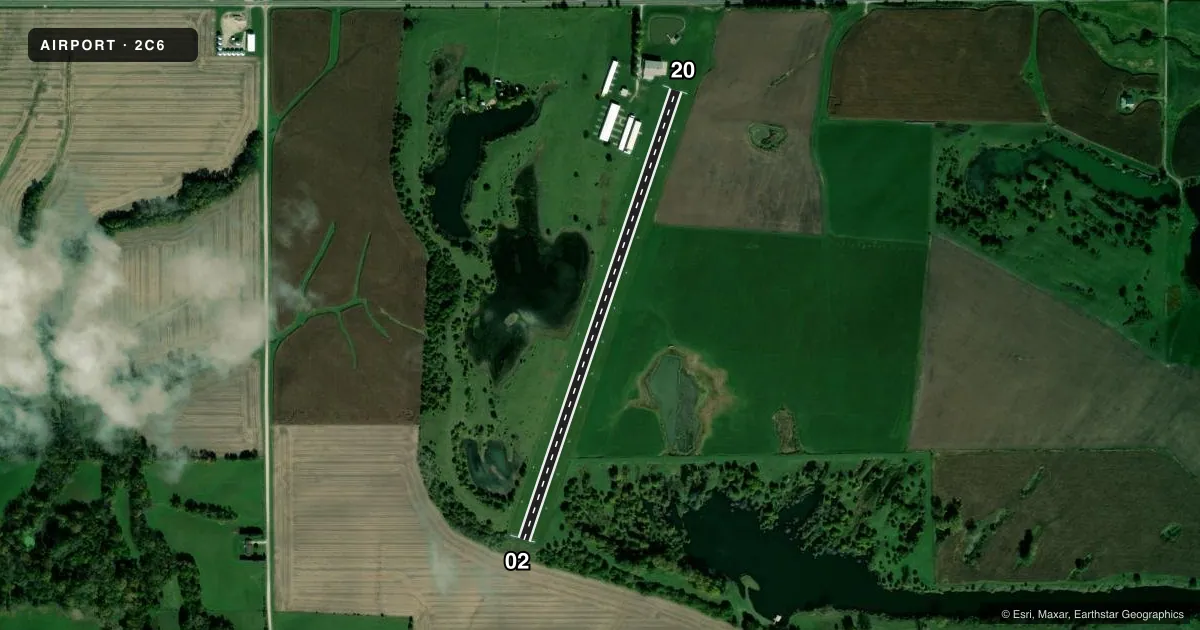
Runways & pattern
Full pagePattern entry · RWY 02
LEFT TRAFFICAirport sketch
Runways drawn to scale from FAA survey coordinates, rendered over satellite imagery. Not for navigation.
Approaches & charts
Services on the field
Fuel grades, oxygen, maintenance, ramp storage and lighting — as declared to the FAA by the airport operator.
Fuel & services
- Fuel
- Not available
- Airframe repair
- Not available
- Power plant repair
- Not available
Ramp & ground
- Transient storage
- Tie-down
- Hangar
- Landing fee
- No fee published
- Lighting schedule
- SEE RMK
- Wind indicator
- Lighted
- Segmented circle
- No
Fuel & FBOs
Cheapest 100LL and Jet A on the field and nearby. Always confirm with the FBO before taxi.
Airport notes
Surface conditions, obstructions, local procedures, lighting outages and other notes published with each FAA cycle.
General notes
- WILDLIFE ON & INVOF ARPT.
- OVERNIGHT CAMPING AND LODGING AVBL WITH PPR, CALL AMGR.
- FOR CD CTC ST LOUIS APCH AT 314-890-1017.
Lighting notes
- ACTVT LIRL RY 02/20 - CTAF.
Runway surface & condition
- 02/20RY 02/20 NSTD LIRL DUE TO SPACING.
Other notes
- THIS AIRPORT HAS BEEN SURVEYED BY THE NATIONAL GEODETIC SURVEY.
- PRVDD OBS ARE REMOVED/LOWERED TO PRVD 20:1 APCH/CLNC, 125' EITHER SIDE OF CNTRLN BE CLEAR OF OBS.
VFR map & nearby airports
VFR sectional. Tap any ICAO chip to open that airport.
Key facts · 2C6
Answer card- ICAO
- 2C6
- Name
- TRI-COUNTY
- Location
- YATES CITY, ILLINOIS
- Elevation
- 661 ft MSL
- Traffic pattern altitude
- 1,661 ft MSL (1,000 AGL)
- Control tower
- Non-towered (use CTAF)
- Total runways
- 1
- Longest runway
- 02/20 · 2,809 ft
- Published ILS approaches
- 0
- Published frequencies
- 1
- Magnetic variation
- 1°
- Current flight rules
- VFR
- Current wind
- 000° at 0 kt
- Favored runway now
- –
TRI-COUNTY is in Yates City, Illinois. The field elevation is 661 ft MSL. It has one runway. The longest is 2,809 ft of turf, runway 02/20, with magnetic headings 19° and 199°. There is no control tower. CTAF is 122.9. No ILS approaches are published here.
Pattern altitude is not published. Use the standard 1,000 ft AGL pattern unless the current Chart Supplement or the airport operator says otherwise. For a light piston, that puts the pattern near 1,661 ft MSL based on the field elevation.
There are no on-field FBOs listed. Call the airport operator directly before arrival if you need services or local field status. Published remarks say overnight camping and lodging may be available with prior permission from the airport manager. Wildlife is reported on and near the airport, so keep a sharp scan on taxi, takeoff and landing. Runway 02/20 has nonstandard low intensity edge lights because of spacing. The lights are activated on CTAF. Clearance delivery is handled through St Louis Approach at 314-890-1017. The remarks also note obstacle clearance requirements near the runway. Check the current Chart Supplement before you go.