METAR & TAF C15
C15 does not publish a METAR.
Showing the nearest reporting station: KPIA (GENERAL DOWNING - PEORIA INTL) · 10.6 NM away. Conditions at C15 may differ.
METAR · KPIA
Observed 13:32Z
KPIA 271332Z 21012G18KT 10SM SCT006 28/25 A2987 RMK AO2 T02780250
- Wind
- 210° @ 12G18 kt
- Visibility
- 10 SM
- Temp / Dew
- 28°C / 25°C
- Altimeter
- 29.87 inHg
- Clouds
- SCT
- Density alt
- 2,279 ft
- Ceiling
- Unlimited
- Rules
- VFR
Airport info & contacts
Manager on record, flight service, ARTCC, attendance schedule and pattern altitude — published by the FAA and refreshed every 28 days.
Location
- From city
- 4 NM S
- VFR sectional
- CHICAGO
- ARTCC
- ZKC · KANSAS CITY
- NOTAM facility
- IKK (NOTAM-D)
Airport manager
- Name
- MICHAEL CRUCE
- Phone
- 309-348-3692
- Address
- 13906 AIRPORT LANE, DIRKSEN PARKWAY, PEKIN IL 61554
Flight service · Hours
- FSS IKK
- KANKAKEE1-800-WX-BRIEF
- Attendance
- MON-FRI · 0800-1700
Frequencies
Tap any row to copy the frequency to your clipboard.
Runways & pattern
Full pagePattern entry · RWY 27
LEFT TRAFFICRunway end performance
| End | TORA | TODA | ASDA | LDA | VGSI | Approach lights | Obstruction |
|---|---|---|---|---|---|---|---|
| 09 | — | — | — | — | PAPI 2-box left(3°) | — | — |
| 27 | — | — | — | — | PAPI 4-box left(3°) | — | — |
Declared distances in feet. TORA = takeoff run available, TODA = takeoff distance, ASDA = accelerate-stop, LDA = landing distance.
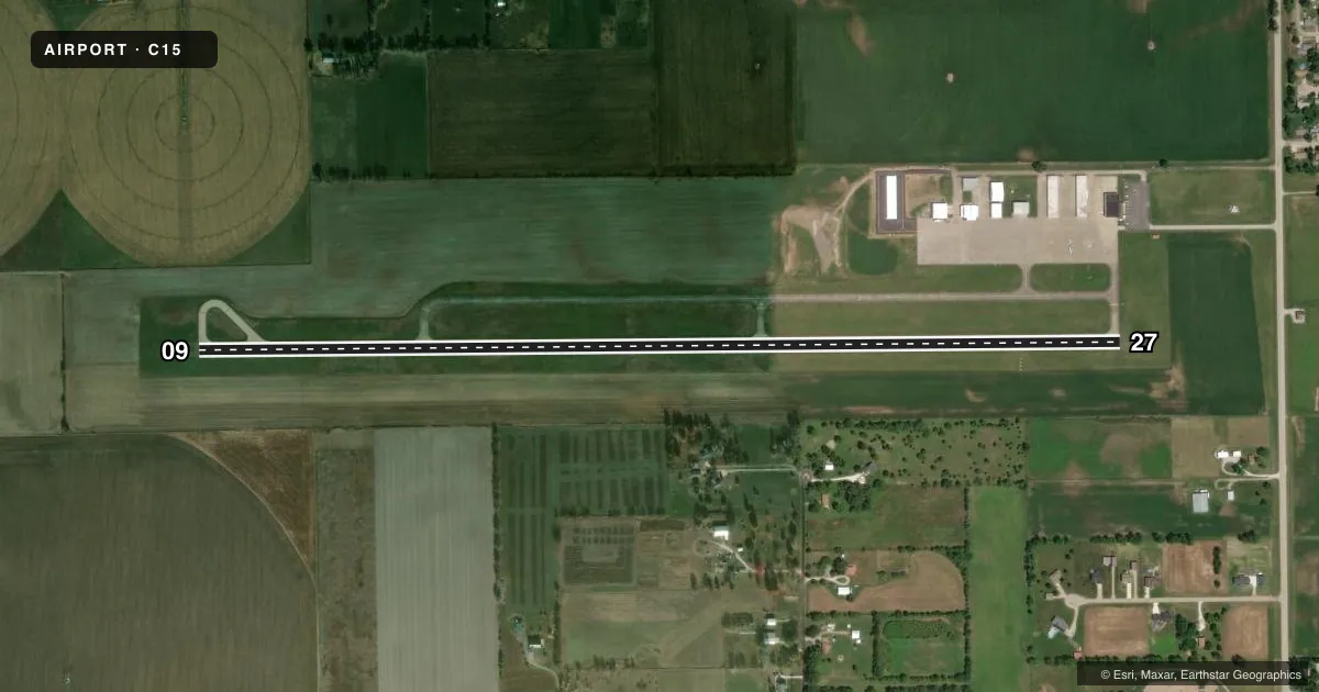
Airport sketch
Runways drawn to scale from FAA survey coordinates, rendered over satellite imagery. Not for navigation.
Approaches & charts
Services on the field
Fuel grades, oxygen, maintenance, ramp storage and lighting — as declared to the FAA by the airport operator.
Fuel & services
- Fuel
- 100LLA
- Airframe repair
- Major
- Power plant repair
- Major
- Other services
- AGRI,AMB,SALES,SURV
Ramp & ground
- Transient storage
- Tie-down
- Hangar
- Landing fee
- No fee published
- Customs
- Not available
- Lighting schedule
- SEE RMK
- Beacon schedule
- SS-SR
- Beacon
- White / Green (civil land)(WG)
- Wind indicator
- Lighted
- Segmented circle
- No
Fuel & FBOs
Cheapest 100LL and Jet A on the field and nearby. Always confirm with the FBO before taxi.
Airport notes
Surface conditions, obstructions, local procedures, lighting outages and other notes published with each FAA cycle.
General notes
- WILDLIFE INVOF ARPT.
- ADMIN BLDG CAN BE ACCESSED BY CIPHER LOCK WHICH HAS APPLICABLE INSTRUCTIONS.
- FOR CD CTC ST LOUIS APCH AT 314-890-1017.
Lighting notes
- ACTVT REIL RWY 09 & 27; PAPI RWY 09 & 27; MIRL RWY 09/27 PRESET ON LOW, TO INCR INTST & ACTVT - CTAF
Other notes
- MANAGERCELL NUMBER 309-287-2496
VFR map & nearby airports
VFR sectional. Tap any ICAO chip to open that airport.
Key facts · C15
Answer card- ICAO
- C15
- Name
- PEKIN MUNI
- Location
- PEKIN, ILLINOIS
- Elevation
- 530 ft MSL
- Traffic pattern altitude
- 1,530 ft MSL (1,000 AGL)
- Control tower
- Non-towered (use CTAF)
- Total runways
- 1
- Longest runway
- 09/27 · 5,000 ft
- Published ILS approaches
- 0
- Published frequencies
- 4
- Magnetic variation
- 2°
- Current flight rules
- VFR
- Current wind
- 210° at 12 kt
- Favored runway now
- RWY 27
Pekin Muni sits in Pekin, Illinois at 530 ft MSL. It has one runway. Runway 09/27 is 5,000 ft of asphalt, which gives a solid margin for light piston work and many turboprop operations. There is no control tower. CTAF and UNICOM are both 122.8. St Louis Approach handles the area on 125.8 and 269.2. Clearance delivery is also handled through St Louis Approach at 314-890-1017.
No ILS approaches are published here. The runway lighting is useful to know before a night arrival. Runway end identifier lights are installed on 09 and 27. PAPI is also installed on both ends. The medium intensity runway lights are preset low. Use the CTAF to bring them up if needed.
Pattern altitude is not published in the facts. Use the standard 1,000 ft AGL for light piston operations unless the current Chart Supplement says otherwise. Wildlife is reported in the area, so keep a sharp scan on taxi, takeoff and final. The airport also has an on-field FBO, Pekin Municipal Airport, which carries AVGAS 100LL and JET A PRIST. The manager cell number is 309-287-2496. If you need access to the administration building, the published cipher lock instructions apply.