METAR & TAF 9I0
9I0 does not publish a METAR.
Showing the nearest reporting station: KSPI (ABRAHAM LINCOLN CAPITAL) · 27.7 NM away. Conditions at 9I0 may differ.
METAR · KSPI
Observed 12:52Z
KSPI 271252Z 20013G22KT 10SM CLR 26/22 A2991 RMK AO2 PK WND 19026/1224 SLP121 T02610222 $
- Wind
- 200° @ 13G22 kt
- Visibility
- 10 SM
- Temp / Dew
- 26°C / 22°C
- Altimeter
- 29.91 inHg
- Clouds
- CLR
- Density alt
- 1,938 ft
- Ceiling
- Unlimited
- Rules
- VFR
Airport info & contacts
Manager on record, flight service, ARTCC, attendance schedule and pattern altitude — published by the FAA and refreshed every 28 days.
Location
- From city
- 5 NM SE
- VFR sectional
- CHICAGO
- ARTCC
- ZKC · KANSAS CITY
- NOTAM facility
- IKK (NOTAM-D)
Airport manager
- Name
- BOB MARTIN
- Phone
- 309-543-9006
- Address
- 18206 QUIVER BEACH RD, HAVANA IL 62644-6895
Flight service · Hours
- FSS IKK
- KANKAKEE1-800-WX-BRIEF
- Attendance
- IREG
Frequencies
Tap any row to copy the frequency to your clipboard.
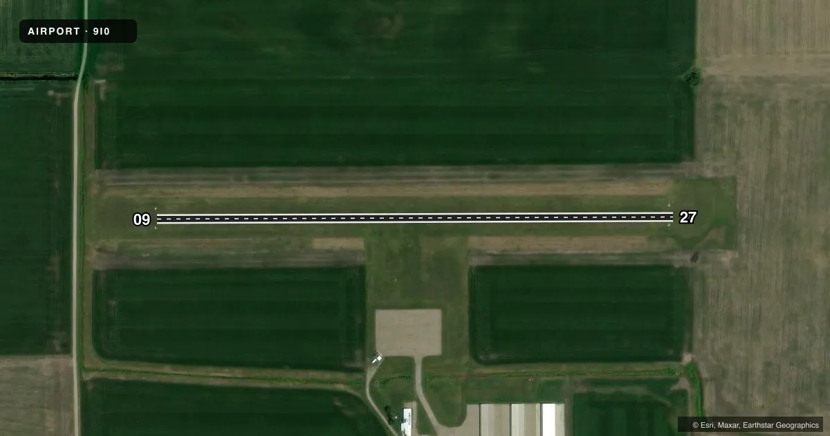
Runways & pattern
Full pagePattern entry · RWY 27
LEFT TRAFFICAirport sketch
Runways drawn to scale from FAA survey coordinates, rendered over satellite imagery. Not for navigation.
Approaches & charts
Services on the field
Fuel grades, oxygen, maintenance, ramp storage and lighting — as declared to the FAA by the airport operator.
Fuel & services
- Fuel
- 100LL
- Oxygen (bottled)
- Not available
- Oxygen (bulk)
- Not available
- Airframe repair
- Not available
- Power plant repair
- Not available
- Other services
- INSTR,SURV
Ramp & ground
- Transient storage
- Tie-down
- Landing fee
- No fee published
- Beacon schedule
- SS-SR
- Beacon
- White / Green (civil land)(WG)
- Wind indicator
- Lighted
- Segmented circle
- No
Fuel & FBOs
Cheapest 100LL and Jet A on the field and nearby. Always confirm with the FBO before taxi.
Airport notes
Surface conditions, obstructions, local procedures, lighting outages and other notes published with each FAA cycle.
General notes
- FOR CD CTC ST LOUIS APCH 314-890-1017.
Fuel notes
- 100LLSELF SVC FUEL AVBL 24 HRS.
Other notes
- MANAGEREMAIL ADDRESS: FLYBYEWIRE@GMAIL.COM (ALL LOWER CASE)
VFR map & nearby airports
VFR sectional. Tap any ICAO chip to open that airport.
Key facts · 9I0
Answer card- ICAO
- 9I0
- Name
- HAVANA RGNL
- Location
- HAVANA, ILLINOIS
- Elevation
- 488.2 ft MSL
- Traffic pattern altitude
- 1,488.2 ft MSL (1,000 AGL)
- Control tower
- Non-towered (use CTAF)
- Total runways
- 1
- Longest runway
- 09/27 · 2,235 ft
- Published ILS approaches
- 0
- Published frequencies
- 1
- Magnetic variation
- 1°
- Current flight rules
- VFR
- Current wind
- 200° at 13 kt
- Favored runway now
- RWY 27
Havana Rgnl Airport sits in Havana, Illinois. Field elevation is 488.2 ft MSL. The airport has one runway. Runway 09/27 is 2,235 ft of turf. The field is non-towered. CTAF is 122.9. No ILS approaches are published here.
Pattern altitude is not published. Use 1,000 ft AGL for light piston traffic unless the current Chart Supplement says otherwise. For this field, that puts the pattern near 1,488 ft MSL. The on-field FBO is Havana Regional Airport. It carries AVGAS 100LL. Self-service fuel is available 24 hours. The published remarks also list a manager email address. For clearance delivery, contact St Louis Approach at 314-890-1017.
First-time pilots should plan for a small turf strip with a single short runway. Check the surface condition before you go. That matters more here than at a paved field. With no tower, standard self-announce procedures on CTAF matter. If you need current operational details, verify them with the airport operator or the current FAA Chart Supplement before departure.