METAR & TAF KPIA
Current METAR
Observed 00:54Z
KPIA 270054Z 00000KT 10SM CLR 31/28 A2985 RMK AO2 SLP103 T03060278 $
- Wind
- 000° @ 0 kt
- Visibility
- 10 SM
- Temp / Dew
- 31°C / 28°C
- Altimeter
- 29.85 inHg
- Clouds
- CLR
- Density alt
- 2,826 ft
- Ceiling
- Unlimited
- Rules
- VFR
Airport info & contacts
Manager on record, flight service, ARTCC, attendance schedule and pattern altitude — published by the FAA and refreshed every 28 days.
Location
- From city
- 4 NM W
- VFR sectional
- CHICAGO
- ARTCC
- ZKC · KANSAS CITY
- NOTAM facility
- PIA (NOTAM-D)
Airport manager
- Name
- GENE OLSON
- Phone
- 309-697-8272
- Address
- 6100 WEST E.M. DIRKSEN PKWY, PEORIA IL 61607
Flight service · Hours
- FSS IKK
- KANKAKEE1-800-WX-BRIEF
- Attendance
- ALL
Frequencies
Tap any row to copy the frequency to your clipboard.
Runways & pattern
Full pagePattern entry · RWY 13
LEFT TRAFFIC| Runway | Heading (°M) | Length | Surface | Traffic |
|---|---|---|---|---|
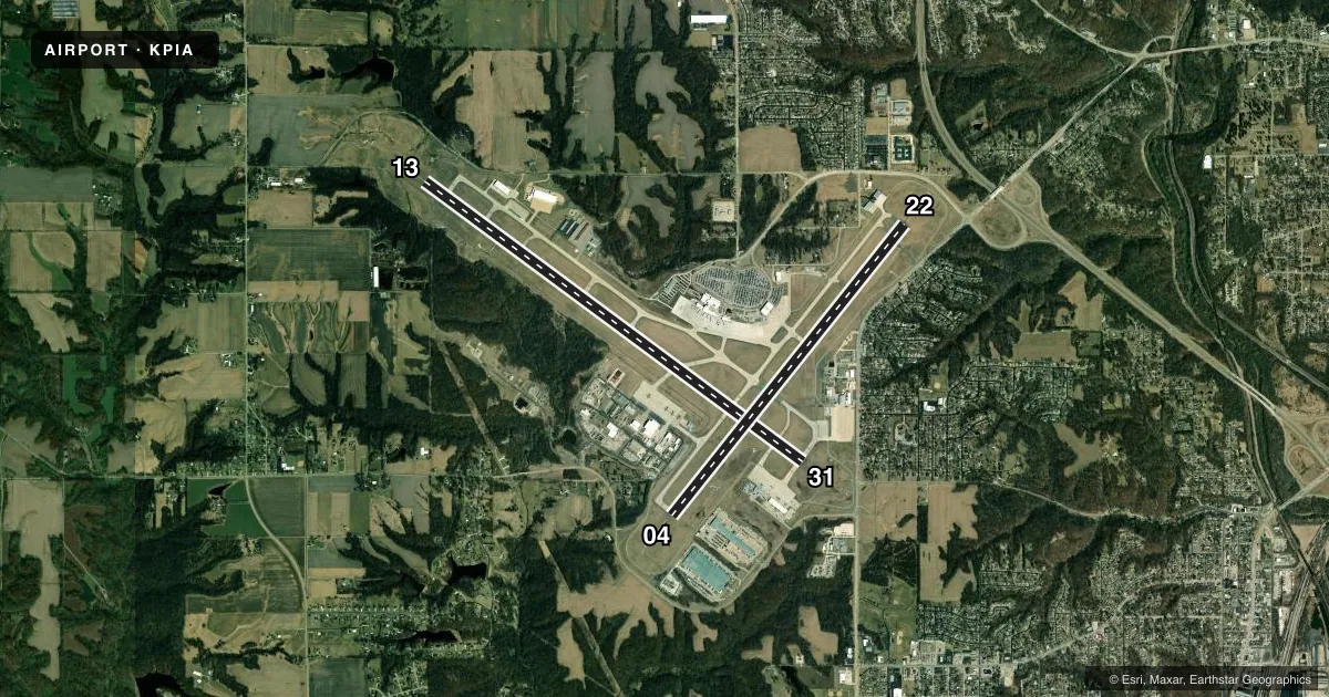
| 13/31 | 125° / 305° | 10,104 ft | CONC | Standard L |
| 04/22 | 37° / 217° | 8,004 ft | ASPH | Standard L |
Runway end performance
| End | TORA | TODA | ASDA | LDA | VGSI | Approach lights | Obstruction |
|---|---|---|---|---|---|---|---|
| 13 | 10,104' | 10,104' | 9,604' | 9,604' | PAPI 4-box right(3°) | MALSR | 137', tree, 5034' from thr, 254' R of cntrln, slope 35 |
| 31 | 10,104' | 10,104' | 10,104' | 10,104' | — | MALSR | 79', tree, 3695' from thr, 458' R of cntrln, slope 44 |
| 04 | 8,004' | 8,004' | 7,826' | 7,826' | PAPI 4-box right(3°) | MALSR | 47', tree, 1013' from thr, 291' R of cntrln, slope 17 |
| 22 | 8,004' | 8,004' | 8,004' | 8,004' | PAPI 4-box left(3°) | — | 93', tree, 2500' from thr, 50' R of cntrln, slope 24 |
Declared distances in feet. TORA = takeoff run available, TODA = takeoff distance, ASDA = accelerate-stop, LDA = landing distance.
Airport sketch
Runways drawn to scale from FAA survey coordinates, rendered over satellite imagery. Not for navigation.
Approaches & charts
ILS · 3
Services on the field
Fuel grades, oxygen, maintenance, ramp storage and lighting — as declared to the FAA by the airport operator.
Fuel & services
- Fuel
- 100LLAA++
- Oxygen (bottled)
- Not available
- Oxygen (bulk)
- HIGH/LOW
- Airframe repair
- Major
- Power plant repair
- Major
- Other services
- CHTR,INSTR,RNTL,SALES
Ramp & ground
- Transient storage
- Tie-down
- Hangar
- Landing fee
- No fee published
- Customs
- Not available
- Beacon schedule
- SS-SR
- Beacon
- White / Green (civil land)(WG)
- Wind indicator
- Lighted
- Segmented circle
- No
Fuel & FBOs
Cheapest 100LL and Jet A on the field and nearby. Always confirm with the FBO before taxi.
Airport notes
Surface conditions, obstructions, local procedures, lighting outages and other notes published with each FAA cycle.
General notes
- LGTD PLINE RWY 04 APCH.
- BIRDS ON AND INVOF ARPT.
- PORTION OF TWY A-5 NOT VISIBLE FROM TWR DUE TO A BLDG.
- ANG: MILITARY AIRCRAFT CALL 'TORCH OPS' 20 MIN PRIOR TO LDG.
Runway surface & condition
- 04/22PCR VALUE: 800/F/C/X/T
- 13/31PCR VALUE: 760/F/C/X/T
Approach & departure obstructions
- 22RWY 22 PAPI UNUSBL BYD 9 DEGS RIGHT OF CNTRLN.
- 13APCH SLOPE 36:1 TO DSPLCD THLD.
Other notes
- MANAGERAIRPORT OPERATIONS 309-697-8272 X 110
VFR map & nearby airports
VFR sectional. Tap any ICAO chip to open that airport.
Key facts · KPIA
Answer card- ICAO
- KPIA
- Name
- GENERAL DOWNING - PEORIA INTL
- Location
- PEORIA, ILLINOIS
- Elevation
- 660.7 ft MSL
- Traffic pattern altitude
- 1,660.7 ft MSL (1,000 AGL)
- Control tower
- Towered · 24
- Total runways
- 2
- Longest runway
- 13/31 · 10,104 ft
- Published ILS approaches
- 3
- Published frequencies
- 15
- Magnetic variation
- 2°
- Current flight rules
- VFR
- Current wind
- 000° at 0 kt
- Favored runway now
- –
General Downing - Peoria Intl sits in Peoria, Illinois. Field elevation is 660.7 ft MSL. The airport has 2 runways. The longest is 13/31 at 10,104 ft. The field is towered 24 hours. ILS approaches are available to runway ends 04, 13 and 31. Pattern altitude is not published, so use the standard 1,000 ft AGL for light piston traffic unless ATC gives you something different.
Byerly Aviation is on the field. It carries 100LL, Jet A and Jet A Prist. Call them at (309) 697-6300 for current service details. Published remarks also matter here. A section of taxiway A-5 is not visible from the tower because of a building. Birds are present on and near the airport. Military aircraft should call Torch Ops 20 minutes before landing. Runway 04 has an approach lighting system. Runway 22 has a PAPI issue beyond 9 degrees right of centerline. The pavement strength is published for both runways. Check your aircraft weight and gear limits before you go.
For a first-time arrival, treat this as a busy controlled field with long pavement and multiple instrument options. Use the current FAA Chart Supplement for any noise or curfew restrictions. If you need airport operations, the published number is 309-697-8272 extension 110.