METAR & TAF C75
Current METAR
Observed 00:15Z
KC75 250015Z AUTO 19004KT 10SM CLR 23/15 A3006 RMK AO2 T02330146
- Wind
- 190° @ 4 kt
- Visibility
- 10 SM
- Temp / Dew
- 23°C / 15°C
- Altimeter
- 30.06 inHg
- Clouds
- CLR
- Density alt
- 1,511 ft
- Ceiling
- Unlimited
- Rules
- VFR
Airport info & contacts
Manager on record, flight service, ARTCC, attendance schedule and pattern altitude — published by the FAA and refreshed every 28 days.
Location
- From city
- 1 NM E
- VFR sectional
- CHICAGO
- ARTCC
- ZAU · CHICAGO
- NOTAM facility
- C75 (NOTAM-D)
Airport manager
- Name
- JOE TROGLIO
- Phone
- 309-246-2870
- Address
- 1315 IL-17, PO BOX 38, LACON IL 61540
Flight service · Hours
- FSS IKK
- KANKAKEE1-800-WX-BRIEF
- Attendance
- 0800-1700
Frequencies
Tap any row to copy the frequency to your clipboard.
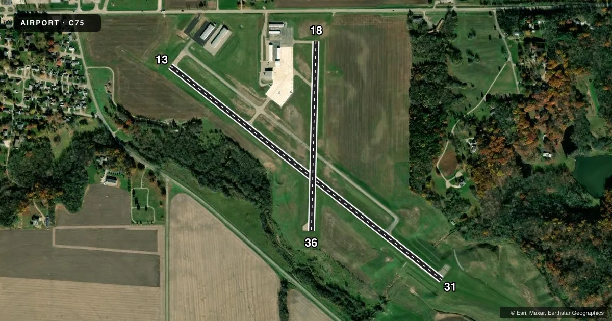
Runways & pattern
Full pagePattern entry · RWY 18
LEFT TRAFFIC| Runway | Heading (°M) | Length | Surface | Traffic |
|---|---|---|---|---|
| 13/31 | 127° / 307° | 4,003 ft | ASPH | 31 R |
| 18/36Favored | 180° / 0° | 2,199 ft | ASPH | Standard L |
Runway end performance
| End | TORA | TODA | ASDA | LDA | VGSI | Approach lights | Obstruction |
|---|---|---|---|---|---|---|---|
| 31 | — | — | — | — | PAPI 4-box left(4°) | — | 56', gnd, 1336' from thr, 0' R of cntrln, slope 20 |
| 18 | — | — | — | — | — | — | 9', road, 334' from thr, 0' R of cntrln, slope 14 |
Declared distances in feet. TORA = takeoff run available, TODA = takeoff distance, ASDA = accelerate-stop, LDA = landing distance.
Airport sketch
Runways drawn to scale from FAA survey coordinates, rendered over satellite imagery. Not for navigation.
Approaches & charts
Services on the field
Fuel grades, oxygen, maintenance, ramp storage and lighting — as declared to the FAA by the airport operator.
Fuel & services
- Fuel
- 100LLUL94
- Oxygen (bottled)
- Not available
- Oxygen (bulk)
- Not available
- Airframe repair
- Major
- Power plant repair
- Major
- Other services
- AVNCS
Ramp & ground
- Transient storage
- Tie-down
- Hangar
- Landing fee
- No fee published
- Customs
- Not available
- Lighting schedule
- SEE RMK
- Beacon schedule
- SS-SR
- Beacon
- White / Green (civil land)(WG)
- Wind indicator
- Lighted
- Segmented circle
- Yes
Fuel & FBOs
Cheapest 100LL and Jet A on the field and nearby. Always confirm with the FBO before taxi.
Airport notes
Surface conditions, obstructions, local procedures, lighting outages and other notes published with each FAA cycle.
General notes
- RY 31 DEPARTURES ENCOURAGED TO BEGIN RIGHT TURN AS SOON AS PRACTICAL FOR NOISE ABATEMENT
- FOR CD CTC CHICAGO ARTCC AT 630-906-8921.
- BIRDS AND ANIMALS ON AND INVOF ARPT.
- RWY 31 R TFC & RWY 13 L TFC DUE TO NOISE ABATEMENT.
Lighting notes
- ACTVT MIRL RY 13/31; REIL RY 13 & PAPI RY 31 - CTAF.
Fuel notes
- 100LL100LL & UL94 AVBL 24HR SELF SVC VIA CREDIT CARD.
Other notes
- MANAGERCELL PHONE: 309-863-5216
VFR map & nearby airports
VFR sectional. Tap any ICAO chip to open that airport.
Key facts · C75
Answer card- ICAO
- C75
- Name
- MARSHALL COUNTY
- Location
- LACON, ILLINOIS
- Elevation
- 584.5 ft MSL
- Traffic pattern altitude
- 1,584.5 ft MSL (1,000 AGL)
- Control tower
- Non-towered (use CTAF)
- Total runways
- 2
- Longest runway
- 13/31 · 4,003 ft
- Published ILS approaches
- 0
- Published frequencies
- 2
- Magnetic variation
- 1°
- Current flight rules
- VFR
- Current wind
- 190° at 4 kt
- Favored runway now
- RWY 18
Marshall County Airport (C75) sits in Lacon, Illinois. Field elevation is 584.5 ft MSL. The airport has two asphalt runways. The longest is 4,003 ft on 13/31. There is no control tower. CTAF and UNICOM are both 122.8.
No ILS approaches are published here. Pattern altitude is not published, so use the standard 1,000 ft AGL for light piston operations unless the current Chart Supplement says otherwise. The on-field FBO is Marshall County Airport. It carries 100LL and UL94. Self-serve fuel is available 24 hours by credit card. Call the FBO at (309) 246-2870 if you need current ramp or fuel details.
Noise abatement matters on this field. Runway 31 uses right traffic. Runway 13 uses left traffic. Runway 31 departures are encouraged to start a right turn as soon as practical. The field also notes birds and animals in and near the airport. Runway 13/31 has medium intensity lighting. REILs are on runway 13. PAPI is on runway 31. Both are activated by CTAF. If you need a clearance, contact Chicago ARTCC at 630-906-8921. For any current restriction or local procedure change, check the current Chart Supplement or call the airport operator before departure.