METAR & TAF 3MY
3MY does not publish a METAR.
Showing the nearest reporting station: KPIA (GENERAL DOWNING - PEORIA INTL) · 8.7 NM away. Conditions at 3MY may differ.
METAR · KPIA
Observed 02:54Z
KPIA 270254Z 00000KT 7SM CLR 29/27 A2987 RMK AO2 SLP109 T02890272 53006 $
- Wind
- 000° @ 0 kt
- Visibility
- 7 SM
- Temp / Dew
- 29°C / 27°C
- Altimeter
- 29.87 inHg
- Clouds
- CLR
- Density alt
- 2,726 ft
- Ceiling
- Unlimited
- Rules
- VFR
Airport info & contacts
Manager on record, flight service, ARTCC, attendance schedule and pattern altitude — published by the FAA and refreshed every 28 days.
Location
- From city
- 7 NM N
- VFR sectional
- CHICAGO
- ARTCC
- ZKC · KANSAS CITY
- NOTAM facility
- IKK (NOTAM-D)
Airport manager
- Name
- GENE OLSON
- Phone
- 309-697-8272
- Address
- GEN DOWNING PEORIA INTL ARPT, 6100 W. DIRKSEN PKWY, PEORIA IL 61607
Flight service · Hours
- FSS IKK
- KANKAKEE1-800-WX-BRIEF
- Attendance
- DAWN-DUSK
Frequencies
Tap any row to copy the frequency to your clipboard.
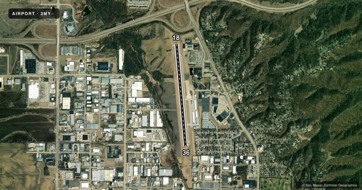
Runways & pattern
Full pagePattern entry · RWY 18
LEFT TRAFFICRunway end performance
| End | TORA | TODA | ASDA | LDA | VGSI | Approach lights | Obstruction |
|---|---|---|---|---|---|---|---|
| 36 | — | — | — | — | VASI 4-box left(3.5°) | — | — |
Declared distances in feet. TORA = takeoff run available, TODA = takeoff distance, ASDA = accelerate-stop, LDA = landing distance.
Airport sketch
Runways drawn to scale from FAA survey coordinates, rendered over satellite imagery. Not for navigation.
Approaches & charts
Services on the field
Fuel grades, oxygen, maintenance, ramp storage and lighting — as declared to the FAA by the airport operator.
Fuel & services
- Fuel
- 100LLA
- Oxygen (bottled)
- HIGH/LOW
- Oxygen (bulk)
- Not available
- Airframe repair
- Major
- Power plant repair
- Major
- Other services
- INSTR,RNTL,SALES
Ramp & ground
- Transient storage
- Tie-down
- Hangar
- Landing fee
- No fee published
- Customs
- Not available
- Lighting schedule
- SEE RMK
- Beacon schedule
- SS-SR
- Beacon
- White / Green (civil land)(WG)
- Wind indicator
- Lighted
- Segmented circle
- No
Fuel & FBOs
Cheapest 100LL and Jet A on the field and nearby. Always confirm with the FBO before taxi.
Airport notes
Surface conditions, obstructions, local procedures, lighting outages and other notes published with each FAA cycle.
Lighting notes
- ACTVT REIL & VASI RY 36.- CTAF, MIRL RWY 18/36 OPERATES SS-SR.
Fuel notes
- 100LL24 HOUR 100LL AND JET-A AVAILABLE WITH CREDIT CARD
Other notes
- MANAGEREMAIL ADDRESS: GOLSON@FLYPIA.COM (ALL LOWER CASE)
- MANAGEREXT 100 OR 103 CELL PHONE: 309-303-0998
VFR map & nearby airports
VFR sectional. Tap any ICAO chip to open that airport.
Key facts · 3MY
Answer card- ICAO
- 3MY
- Name
- MOUNT HAWLEY AUXILIARY
- Location
- PEORIA, ILLINOIS
- Elevation
- 793.4 ft MSL
- Traffic pattern altitude
- 1,793.4 ft MSL (1,000 AGL)
- Control tower
- Non-towered (use CTAF)
- Total runways
- 1
- Longest runway
- 18/36 · 4,001 ft
- Published ILS approaches
- 0
- Published frequencies
- 5
- Magnetic variation
- 2°
- Current flight rules
- VFR
- Current wind
- 000° at 0 kt
- Favored runway now
- –
Mount Hawley Auxiliary Airport sits in Peoria, Illinois. Field elevation is 793.4 ft MSL. The airport has one runway. Runway 18/36 is 4,001 ft long with an asphalt surface. The field is not towered. CTAF and UNICOM are both 122.7. Approach and departure services are handled by St. Louis on 125.8 or 269.2.
No ILS approaches are published here. Pattern altitude is not published, so use the standard 1,000 ft AGL for light piston traffic unless the current Chart Supplement says otherwise. Runway 36 has REIL and a VASI. Medium intensity runway lights for 18/36 operate from sunset to sunrise. That helps at night. It also means you should brief the lighting setup before arrival.
The on-field FBO is Mount Hawley Auxiliary Airport. It carries 100LL and Jet A. Published remarks also note 24-hour self-serve fuel with credit card. If you need the manager, the published contact details are in the Chart Supplement. For a first-time arrival, the main things to plan for are the single-runway layout, the non-towered pattern and the lack of published ILS. Check the current Chart Supplement for any noise or local operating notes before you go.