METAR & TAF KIJX
Current METAR
Observed 13:15Z
KIJX 271315Z AUTO 19014G18KT 10SM SCT008 27/27 A2991 RMK AO2 T02740270
- Wind
- 190° @ 14G18 kt
- Visibility
- 10 SM
- Temp / Dew
- 27°C / 27°C
- Altimeter
- 29.91 inHg
- Clouds
- SCT
- Density alt
- 2,226 ft
- Ceiling
- Unlimited
- Rules
- VFR
Airport info & contacts
Manager on record, flight service, ARTCC, attendance schedule and pattern altitude — published by the FAA and refreshed every 28 days.
Location
- From city
- 3 NM N
- VFR sectional
- ST LOUIS
- ARTCC
- ZKC · KANSAS CITY
- NOTAM facility
- IJX (NOTAM-D)
Airport manager
- Name
- SHASTIN SAXER
- Phone
- 217-243-5824
- Address
- 1956 BALDWIN RD, JACKSONVILLE AIRPORT, JACKSONVILLE IL 62650
Flight service · Hours
- FSS STL
- SAINT LOUIS1-800-WX-BRIEF
- Attendance
- 0700-DUSK
Frequencies
Tap any row to copy the frequency to your clipboard.
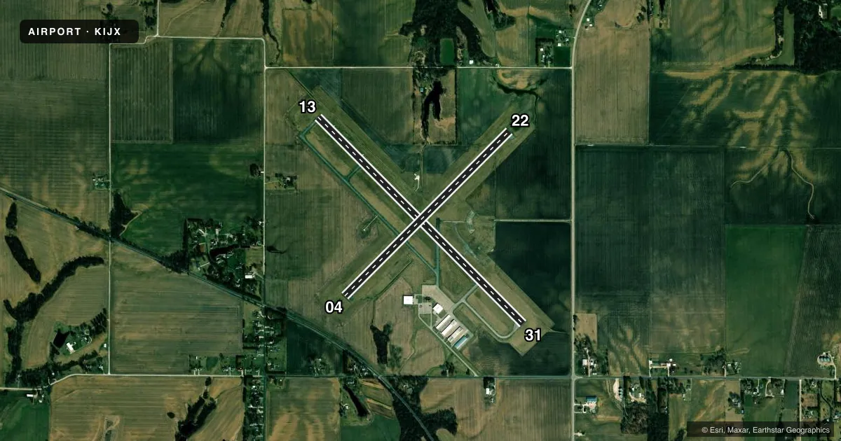
Runways & pattern
Full pagePattern entry · RWY 22
LEFT TRAFFIC| Runway | Heading (°M) | Length | Surface | Traffic |
|---|---|---|---|---|
| 13/31 | 132° / 312° | 5,000 ft | ASPH | Standard L |
| 04/22Favored | 42° / 222° | 4,001 ft | ASPH | Standard L |
Runway end performance
| End | TORA | TODA | ASDA | LDA | VGSI | Approach lights | Obstruction |
|---|---|---|---|---|---|---|---|
| 13 | — | — | — | — | VASI 4-box left(3°) | — | — |
Declared distances in feet. TORA = takeoff run available, TODA = takeoff distance, ASDA = accelerate-stop, LDA = landing distance.
Airport sketch
Runways drawn to scale from FAA survey coordinates, rendered over satellite imagery. Not for navigation.
Approaches & charts
Services on the field
Fuel grades, oxygen, maintenance, ramp storage and lighting — as declared to the FAA by the airport operator.
Fuel & services
- Fuel
- 100LLA
- Oxygen (bottled)
- Not available
- Oxygen (bulk)
- Not available
- Airframe repair
- Major
- Power plant repair
- Major
- Other services
- INSTR,RNTL
Ramp & ground
- Transient storage
- Tie-down
- Hangar
- Landing fee
- No fee published
- Customs
- Not available
- Lighting schedule
- SEE RMK
- Beacon schedule
- SS-SR
- Beacon
- White / Green (civil land)(WG)
- Wind indicator
- Lighted
- Segmented circle
- No
Fuel & FBOs
Cheapest 100LL and Jet A on the field and nearby. Always confirm with the FBO before taxi.
Airport notes
Surface conditions, obstructions, local procedures, lighting outages and other notes published with each FAA cycle.
General notes
- DEER ON & INVOF OF ARPT.
- FOR CD CTC ST LOUIS APCH 314-890-1017.
Lighting notes
- ACTVT MIRL RY 13/31, 04/22, REIL RYS 22, 13 & 31, & TWY LGTS - CTAF.
Other notes
- MANAGEREMAIL ADDRESS: MANAGER@FLYIJX.COM. (ALL LOWER CASE)
VFR map & nearby airports
VFR sectional. Tap any ICAO chip to open that airport.
Key facts · KIJX
Answer card- ICAO
- KIJX
- Name
- JACKSONVILLE MUNI
- Location
- JACKSONVILLE, ILLINOIS
- Elevation
- 623.9 ft MSL
- Traffic pattern altitude
- 1,623.9 ft MSL (1,000 AGL)
- Control tower
- Non-towered (use CTAF)
- Total runways
- 2
- Longest runway
- 13/31 · 5,000 ft
- Published ILS approaches
- 0
- Published frequencies
- 5
- Magnetic variation
- 3°
- Current flight rules
- VFR
- Current wind
- 190° at 14 kt
- Favored runway now
- RWY 22
Jacksonville Muni is in Jacksonville, Illinois. The field elevation is 623.9 ft MSL. It has two asphalt runways. The longest is runway 13/31 at 5,000 ft. Runway 04/22 is 4,001 ft.
This is a non-towered airport. CTAF and UNICOM are both 122.8. Clearance delivery is handled through St Louis Approach. The published contact number is 314-890-1017. No ILS approaches are published here, so plan with current weather and the latest charted procedures before you go.
The pattern altitude is not published. Use 1,000 ft AGL for light piston traffic unless the current Chart Supplement says otherwise. The airport sits in a flat part of Illinois. The main operational issues are traffic awareness and staying alert for deer on and near the field. Medium intensity runway lights are available on both runways. Runway end identifier lights are on 22, 13 and 31. Taxiway lights are controlled on CTAF.
Jacksonville Municipal Airport is on the field. It carries 100LL and Jet A. If you need current ramp or fuel details, call the airport directly at (217) 243-5824 before arrival.