METAR & TAF KPPQ
Current METAR
Observed 17:55Z
KPPQ 141755Z AUTO 05006KT 10SM 31/22 A3020 RMK AO2 6//// T03070216
- Wind
- 050° @ 6 kt
- Visibility
- 10 SM
- Temp / Dew
- 31°C / 22°C
- Altimeter
- 30.20 inHg
- Clouds
- Clear
- Density alt
- 2,453 ft
- Ceiling
- Unlimited
- Rules
- VFR
Airport info & contacts
Manager on record, flight service, ARTCC, attendance schedule and pattern altitude — published by the FAA and refreshed every 28 days.
Location
- From city
- 3 NM NE
- VFR sectional
- ST LOUIS
- ARTCC
- ZKC · KANSAS CITY
- NOTAM facility
- PPQ (NOTAM-D)
Airport manager
- Name
- JOHN SCHULTZ
- Phone
- 217-285-6027
- Address
- 29296 US HWY 54, PITTSFIELD IL 62363
Flight service · Hours
- FSS STL
- SAINT LOUIS1-800-WX-BRIEF
- Attendance
- MON-FRI · 0800-1700
Frequencies
Tap any row to copy the frequency to your clipboard.
Runways & pattern
Full pagePattern entry · RWY 13
LEFT TRAFFICRunway end performance
| End | TORA | TODA | ASDA | LDA | VGSI | Approach lights | Obstruction |
|---|---|---|---|---|---|---|---|
| 13 | — | — | — | — | PAPI 2-box left(3°) | — | — |
| 31 | — | — | — | — | PAPI 2-box left(3°) | — | — |
Declared distances in feet. TORA = takeoff run available, TODA = takeoff distance, ASDA = accelerate-stop, LDA = landing distance.
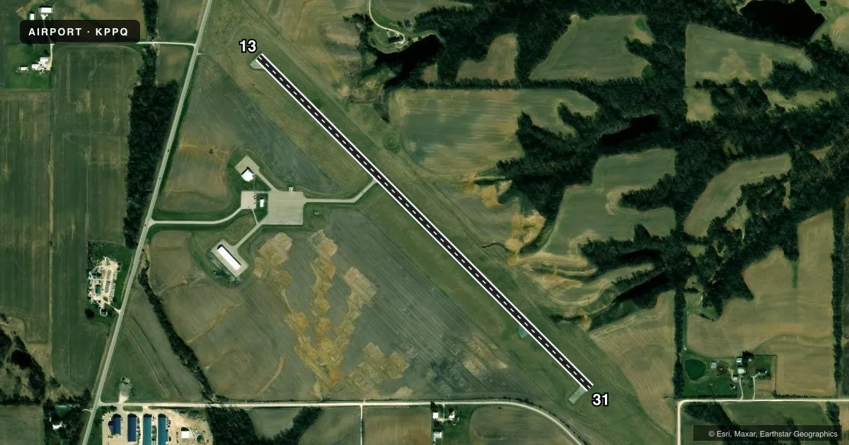
Airport sketch
Runways drawn to scale from FAA survey coordinates, rendered over satellite imagery. Not for navigation.
Approaches & charts
Services on the field
Fuel grades, oxygen, maintenance, ramp storage and lighting — as declared to the FAA by the airport operator.
Fuel & services
- Fuel
- 100LLA
- Oxygen (bulk)
- Not available
Ramp & ground
- Transient storage
- Tie-down
- Hangar
- Landing fee
- No fee published
- Customs
- Not available
- Lighting schedule
- SEE RMK
- Beacon schedule
- SS-SR
- Beacon
- White / Green (civil land)(WG)
- Wind indicator
- Lighted
- Segmented circle
- Yes
Fuel & FBOs
Cheapest 100LL and Jet A on the field and nearby. Always confirm with the FBO before taxi.
Airport notes
Surface conditions, obstructions, local procedures, lighting outages and other notes published with each FAA cycle.
General notes
- DEER & MIGRATORY WATERFOWL ON & INVOF ARPT.
- (E81) TWY LGTS ARE LGTD EXIT ARROWS.
- FOR CD CTC KANSAS CITY ARTCC AT 913-254-8508.
Lighting notes
- MIRL RY 13/31 PRESET ON LOW INTST; TO INCREASE INTST & ACTVT MIRL RY 13/31 - CTAF.
Fuel notes
- 100LL24 HR SELF SVC CREDIT CARD (MAJOR) FUEL FAC.
Approach & departure obstructions
- 13RWY 13 MARKINGS POOR DUE TO FADING.
- 31RWY 31 MARKINGS POOR DUE TO FADING.
- 13RY 13 PAPI, OPERATE CONTINUOUSLY.
- 31RY 31 PAPI, OPERATE CONTINUOUSLY.
VFR map & nearby airports
VFR sectional. Tap any ICAO chip to open that airport.
Key facts · KPPQ
Answer card- ICAO
- KPPQ
- Name
- PITTSFIELD PENSTONE MUNI
- Location
- PITTSFIELD, ILLINOIS
- Elevation
- 709.8 ft MSL
- Traffic pattern altitude
- 1,709.8 ft MSL (1,000 AGL)
- Control tower
- Non-towered (use CTAF)
- Total runways
- 1
- Longest runway
- 13/31 · 4,000 ft
- Published ILS approaches
- 0
- Published frequencies
- 2
- Magnetic variation
- 2°
- Current flight rules
- VFR
- Current wind
- 050° at 6 kt
- Favored runway now
- RWY 13
Pittsfield Penstone Muni is in Pittsfield, Illinois. Field elevation is 709.8 ft MSL. The airport has one runway, 13/31, which is 4,000 ft long and asphalt. There is no control tower. CTAF and UNICOM are both 122.8. No ILS approaches are published here.
Pattern altitude is not published. For light piston traffic, use 1,000 ft AGL unless the current Chart Supplement or local procedures say otherwise. The on-field FBO is Pittsfield Penstone Municipal Airport. It carries 100LL and JET A. A 24-hour self-serve credit card fuel facility is available for 100LL.
A few runway details matter here. Runway 13 and Runway 31 markings are reported as poor due to fading. Runway 13 and Runway 31 both have PAPIs that operate continuously. The medium intensity runway lights on 13/31 are preset low. Use the CTAF to increase intensity and activate the lights. Deer and migratory waterfowl are reported on and near the airport, so keep a sharp scan on arrival and departure. For clearance delivery, contact Kansas City ARTCC at 913-254-8508. If you need current noise or operational guidance beyond these remarks, check the current FAA Chart Supplement or call the airport operator before you go.