METAR & TAF KUIN
Current METAR
Observed 12:54Z
KUIN 271254Z AUTO 20007KT 10SM CLR 28/24 A2987 RMK AO2 SLP105 T02830244 TSNO
- Wind
- 200° @ 7 kt
- Visibility
- 10 SM
- Temp / Dew
- 28°C / 24°C
- Altimeter
- 29.87 inHg
- Clouds
- CLR
- Density alt
- 2,575 ft
- Ceiling
- Unlimited
- Rules
- VFR
Airport info & contacts
Manager on record, flight service, ARTCC, attendance schedule and pattern altitude — published by the FAA and refreshed every 28 days.
Location
- From city
- 10 NM E
- VFR sectional
- KANSAS CITY
- ARTCC
- ZKC · KANSAS CITY
- NOTAM facility
- UIN (NOTAM-D)
Airport manager
- Name
- BILL LANTZ
- Phone
- 217-885-3285
- Address
- 1645 HWY 104, QUINCY IL 62305
Flight service · Hours
- FSS STL
- SAINT LOUIS1-800-WX-BRIEF
- Attendance
- MON-FRI · 0600-2000
- SAT · 0600-2000
- SUN · 0600-2000
Frequencies
Tap any row to copy the frequency to your clipboard.
Runways & pattern
Full pagePattern entry · RWY 22
LEFT TRAFFIC| Runway | Heading (°M) | Length | Surface | Traffic |
|---|---|---|---|---|
| 04/22Favored | 38° / 218° | 7,098 ft | ASPH | Standard L |
| 13/31 | 133° / 313° | 5,397 ft | ASPH | Standard L |
Runway end performance
| End | TORA | TODA | ASDA | LDA | VGSI | Approach lights | Obstruction |
|---|---|---|---|---|---|---|---|
| 04 | 7,098' | 7,098' | 7,098' | 7,098' | PAPI 4-box right(3°) | MALSR | 16', road, 848' from thr, 586' R of cntrln, slope 40 |
| 22 | 7,098' | 7,098' | 7,098' | 7,098' | PAPI 4-box left(3°) | — | — |
| 13 | 5,397' | 5,397' | 5,123' | 5,123' | PAPI 4-box left(3°) | — | 11', road, 525' from thr, 300' R of cntrln, slope 29 |
| 31 | 5,397' | 5,397' | 5,146' | 5,146' | PAPI 4-box right(3°) | — | 15', pole, 800' from thr, 200' R of cntrln, slope 40 |
Declared distances in feet. TORA = takeoff run available, TODA = takeoff distance, ASDA = accelerate-stop, LDA = landing distance.
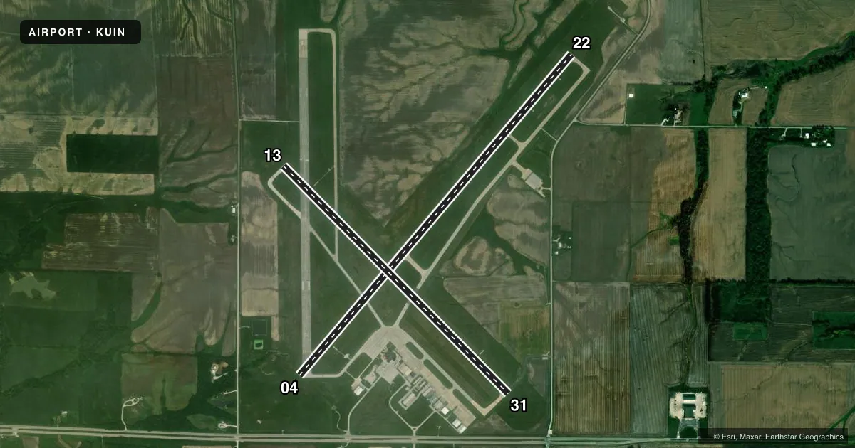
Airport sketch
Runways drawn to scale from FAA survey coordinates, rendered over satellite imagery. Not for navigation.
Approaches & charts
ILS · 1
Services on the field
Fuel grades, oxygen, maintenance, ramp storage and lighting — as declared to the FAA by the airport operator.
Fuel & services
- Fuel
- 100LLA
- Airframe repair
- Not available
- Power plant repair
- Not available
- Other services
- AMB,CHTR,INSTR,RNTL
Ramp & ground
- Transient storage
- Tie-down
- Landing fee
- No fee published
- Customs
- Not available
- Lighting schedule
- SEE RMK
- Beacon schedule
- SS-SR
- Beacon
- White / Green (civil land)(WG)
- Wind indicator
- Lighted
- Segmented circle
- No
Fuel & FBOs
Cheapest 100LL and Jet A on the field and nearby. Always confirm with the FBO before taxi.
Airport notes
Surface conditions, obstructions, local procedures, lighting outages and other notes published with each FAA cycle.
General notes
- MIGRATORY WATERFOWL ON & INVOF ARPT.
- FICONS NOT MONITORED DAILY BTWN 2200-0600 LCL HRS.
- ARPT WDI OTS INDEFLY.
- USE CTN; NO LINE OF SIGHT BTWN RWY ENDS DUE TO TOPOGRAPHY AND BLDG OBSTNS; ALL DEP/ARR ACFT USE CTAF 123.0.
- FOR CD IF UNA TO CTC ON FSS FREQ, CTC KANSAS CITY ARTCC AT 913-254-8508.
- ARFF NOT AVBL 24 HRS. 24HRS PPR FOR UNSKED ACR OPS; CTC ARPT MGR 217-577-9589 OR 217-885-3262.
- RWY 04 IS THE PREFERRED RWY IN CALM WIND CONDITIONS.
Lighting notes
- ACTVT MALSR RWY 04; REIL RWY 22; PAPI RWY 13, 31, 04 & 22; HIRL RWY 04/22; MIRL RWY 13/31 - CTAF. HIRL RWY 04/22 PRESET LOW INTST; TO INCR INTST - CTAF.
Runway surface & condition
- 04/22PCR VALUE: 1500/F/D/X/T
- 13/31PCR VALUE: 1310/F/D/X/T
Approach & departure obstructions
- 13PAPI UNUSBL BYD 9 DEGS RIGHT OF CNTRLN.
Other notes
- 2FOR FUEL ATTENDANT OTR HRS CALL 217-885-3353 OR 217-779-5091. ACFT MAINT TO COORD CALL 217-885-3353.
- MANAGEREMAIL ADDRESS: QCYAIRPORTADMIN@QUINCYIL.GOV
- OWNER217-577-9589
VFR map & nearby airports
VFR sectional. Tap any ICAO chip to open that airport.
Key facts · KUIN
Answer card- ICAO
- KUIN
- Name
- QUINCY RGNL-BALDWIN FLD
- Location
- QUINCY, ILLINOIS
- Elevation
- 768.5 ft MSL
- Traffic pattern altitude
- 1,768.5 ft MSL (1,000 AGL)
- Control tower
- Non-towered (use CTAF)
- Total runways
- 2
- Longest runway
- 04/22 · 7,098 ft
- Published ILS approaches
- 1
- Published frequencies
- 2
- Magnetic variation
- 2°
- Current flight rules
- VFR
- Current wind
- 200° at 7 kt
- Favored runway now
- RWY 22
Quincy Rgnl-Baldwin Fld is in Quincy, Illinois. Field elevation is 768.7 ft MSL. The airport has two asphalt runways. The longest is 7,098 ft on 04/22. Runway 13/31 is 5,397 ft. There is no control tower. CTAF and UNICOM are both 123.0.
Runway 04 has the only published ILS approach. The field also has MALSR on 04. Runway 22 has REIL. PAPI is published on all runway ends. In calm wind, runway 04 is the preferred runway. The published pattern altitude is not listed. Use standard 1,000 ft AGL for light piston traffic unless the current Chart Supplement says otherwise. That puts the pattern near 1,769 ft MSL.
Quincy Aviation is on the field. It carries 100LL, Jet A and Jet A Prist. Call them at (217) 885-3353 for current fuel or after-hours help. The airport remarks also call out topography and building obstructions that block line of sight between runway ends. That matters for traffic calls on CTAF. ARFF is not available 24 hours. Unscheduled operations need 24 hours prior permission. Migratory waterfowl are also reported in the area, so keep a sharp scan on arrival and departure.