METAR & TAF KEOK
Current METAR
Observed 06:15Z
KEOK 270615Z AUTO 21004KT 10SM CLR 28/27 A2984 RMK A01
- Wind
- 210° @ 4 kt
- Visibility
- 10 SM
- Temp / Dew
- 28°C / 27°C
- Altimeter
- 29.84 inHg
- Clouds
- CLR
- Density alt
- 2,492 ft
- Ceiling
- Unlimited
- Rules
- VFR
Airport info & contacts
Manager on record, flight service, ARTCC, attendance schedule and pattern altitude — published by the FAA and refreshed every 28 days.
Location
- From city
- 4 NM NW
- VFR sectional
- CHICAGO
- ARTCC
- ZKC · KANSAS CITY
- NOTAM facility
- EOK (NOTAM-D)
Airport manager
- Name
- RAYMOND OTT
- Phone
- 319-524-6203
- Address
- 2504 340TH STREET, KEOKUK IA 52632
Flight service · Hours
- FSS FOD
- FORT DODGE1-800-WX-BRIEF
- Attendance
- MON-FRI · 0800-1630
Frequencies
Tap any row to copy the frequency to your clipboard.
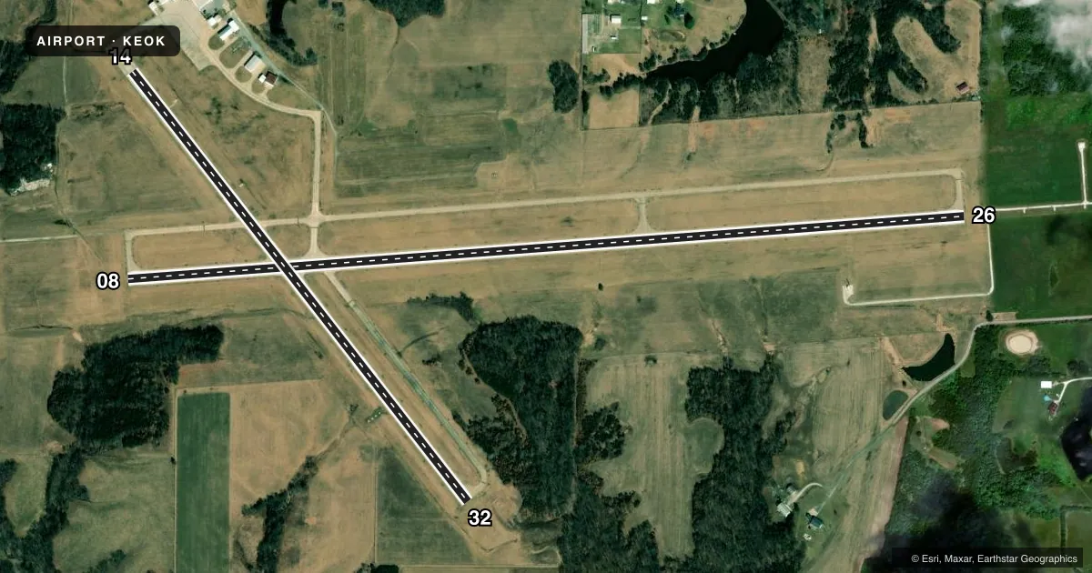
Runways & pattern
Full pagePattern entry · RWY 26
LEFT TRAFFIC| Runway | Heading (°M) | Length | Surface | Traffic |
|---|---|---|---|---|
| 08/26Favored | 84° / 264° | 5,500 ft | CONC | Standard L |
| 14/32 | 140° / 320° | 3,576 ft | CONC | Standard L |
Runway end performance
| End | TORA | TODA | ASDA | LDA | VGSI | Approach lights | Obstruction |
|---|---|---|---|---|---|---|---|
| 08 | — | — | — | — | PAPI 4-box left(3°) | — | — |
| 26 | — | — | — | — | PAPI 4-box left(3°) | MALSR | — |
| 14 | — | — | — | — | VASI 4-box left(3°) | — | 38', tree, 1064' from thr, 96' R of cntrln, slope 22 |
| 32 | — | — | — | — | PAPI 4-box left(3°) | — | 46', tree, 1219' from thr, 60' R of cntrln, slope 22 |
Declared distances in feet. TORA = takeoff run available, TODA = takeoff distance, ASDA = accelerate-stop, LDA = landing distance.
Airport sketch
Runways drawn to scale from FAA survey coordinates, rendered over satellite imagery. Not for navigation.
Approaches & charts
ILS · 1
Services on the field
Fuel grades, oxygen, maintenance, ramp storage and lighting — as declared to the FAA by the airport operator.
Fuel & services
- Fuel
- 100LLA
- Oxygen (bottled)
- Not available
- Oxygen (bulk)
- Not available
- Airframe repair
- Not available
- Power plant repair
- Not available
Ramp & ground
- Transient storage
- Tie-down
- Landing fee
- No fee published
- Customs
- Not available
- Lighting schedule
- SEE RMK
- Beacon schedule
- SS-SR
- Beacon
- White / Green (civil land)(WG)
- Wind indicator
- Lighted
- Segmented circle
- No
Fuel & FBOs
Cheapest 100LL and Jet A on the field and nearby. Always confirm with the FBO before taxi.
Airport notes
Surface conditions, obstructions, local procedures, lighting outages and other notes published with each FAA cycle.
General notes
- FOR SVC AFT HRS CALL 319-371-9998.
- UNLIGHTED TOWER APRXLY 1000 FT MSL 4 MILES SE.
- RY 26 IS CALM WIND RY.
- ULTRALIGHT AIRCRAFT OPERATIONS INVOF
- FOR CD IF UNA TO CTC ON FSS FREQ, CTC KANSAS CITY ARTCC AT 913-254-8508.
Lighting notes
- ACTVT MALSR RWY 26; REIL RWYS 08, 14 & 32; VASI RWY 14; PAPI RWYS 08, 26 & 32; MIRL RWYS 08/26 & 14/32 - CTAF.
Other notes
- THIS AIRPORT HAS BEEN SURVEYED BY THE NATIONAL GEODETIC SURVEY.
- 1CLSD MAJOR HOL; 24 HR SELF SERVE FUEL AVBL
VFR map & nearby airports
VFR sectional. Tap any ICAO chip to open that airport.
Key facts · KEOK
Answer card- ICAO
- KEOK
- Name
- KEOKUK MUNI
- Location
- KEOKUK, IOWA
- Elevation
- 671.9 ft MSL
- Traffic pattern altitude
- 1,671.9 ft MSL (1,000 AGL)
- Control tower
- Non-towered (use CTAF)
- Total runways
- 2
- Longest runway
- 08/26 · 5,500 ft
- Published ILS approaches
- 1
- Published frequencies
- 2
- Magnetic variation
- 2°
- Current flight rules
- VFR
- Current wind
- 210° at 4 kt
- Favored runway now
- RWY 26
Keokuk Muni sits in Keokuk, Iowa at 671.9 ft MSL. It has two concrete runways. The longest is 08/26 at 5,500 ft. The field is non-towered. CTAF and UNICOM are both 122.8. Pattern altitude is not published in the facts, so use the standard 1,000 ft AGL for light piston traffic unless the current Chart Supplement says otherwise.
Runway 26 has the ILS approach. The published remarks also note medium intensity approach lighting with runway alignment indicator lights for 26. Runway end identifier lights are installed on 08, 14 and 32. PAPI is available on 08, 26 and 32. VASI is available on 14. All lighting is controlled on the common traffic advisory frequency. Listen before keying up.
Keokuk Municipal Airport is the on-field FBO. It carries 100LL and Jet A with Prist. 24-hour self-serve fuel is available. The airport is closed on major holidays. There is also an unlighted tower about 4 miles southeast, listed at roughly 1,000 ft MSL. Runway 26 is the calm wind runway. Ultralight operations are noted in the vicinity. Keep your scan active in the pattern and on taxi. For after-hours service, the published remarks list a phone number. Check in before you go if you need anything outside normal hours.