METAR & TAF KMPZ
Current METAR
Observed 14:55Z
KMPZ 271455Z AUTO 23006KT 10SM -RA SCT100 28/25 A2984 RMK AO2
- Wind
- 230° @ 6 kt
- Visibility
- 10 SM
- Temp / Dew
- 28°C / 25°C
- Altimeter
- 29.84 inHg
- Clouds
- SCT
- Density alt
- 2,565 ft
- Ceiling
- Unlimited
- Rules
- VFR
Airport info & contacts
Manager on record, flight service, ARTCC, attendance schedule and pattern altitude — published by the FAA and refreshed every 28 days.
Location
- From city
- 3 NM SE
- VFR sectional
- CHICAGO
- ARTCC
- ZAU · CHICAGO
- NOTAM facility
- MPZ (NOTAM-D)
Airport manager
- Name
- CLIFFORD BAKER
- Phone
- 319-385-8122
- Address
- 1720 SOUTH IRIS STREET, MT PLEASANT IA 52641
Flight service · Hours
- FSS FOD
- FORT DODGE1-800-WX-BRIEF
- Attendance
- MON-FRI · 0800-1700
- SAT-SUN · ON-CALL
Frequencies
Tap any row to copy the frequency to your clipboard.
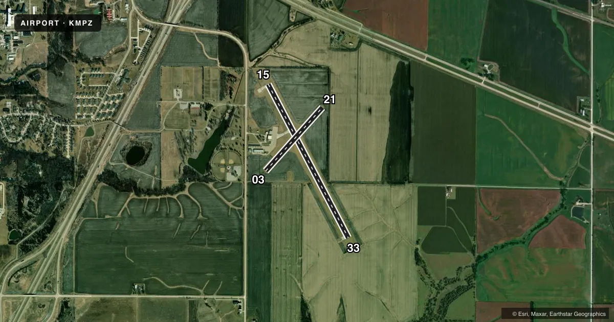
Runways & pattern
Full pagePattern entry · RWY 21
LEFT TRAFFIC| Runway | Heading (°M) | Length | Surface | Traffic |
|---|---|---|---|---|
| 15/33 | 152° / 332° | 4,001 ft | CONC | 33 R |
| 03/21Favored | 42° / 222° | 1,967 ft | TURF | Standard L |
Runway end performance
| End | TORA | TODA | ASDA | LDA | VGSI | Approach lights | Obstruction |
|---|---|---|---|---|---|---|---|
| 15 | — | — | — | — | PAPI 2-box left(3°) | — | 17', trees, 589' from thr, 55' R of cntrln, slope 22 |
| 33 | — | — | — | — | PAPI 2-box left(3°) | — | 4', fence, 295' from thr, 0' R of cntrln, slope 23 |
| 03 | — | — | — | — | — | — | 15', road, 670' from thr, slope 44 |
Declared distances in feet. TORA = takeoff run available, TODA = takeoff distance, ASDA = accelerate-stop, LDA = landing distance.
Airport sketch
Runways drawn to scale from FAA survey coordinates, rendered over satellite imagery. Not for navigation.
Approaches & charts
Services on the field
Fuel grades, oxygen, maintenance, ramp storage and lighting — as declared to the FAA by the airport operator.
Fuel & services
- Fuel
- 100LLA
- Oxygen (bottled)
- Not available
- Oxygen (bulk)
- Not available
- Airframe repair
- Major
- Power plant repair
- Major
- Other services
- AGRI,CHTR,INSTR,RNTL,SURV
Ramp & ground
- Transient storage
- Tie-down
- Hangar
- Landing fee
- No fee published
- Customs
- Not available
- Lighting schedule
- SEE RMK
- Beacon schedule
- SS-SR
- Beacon
- White / Green (civil land)(WG)
- Wind indicator
- Lighted
- Segmented circle
- No
Fuel & FBOs
Cheapest 100LL and Jet A on the field and nearby. Always confirm with the FBO before taxi.
Airport notes
Surface conditions, obstructions, local procedures, lighting outages and other notes published with each FAA cycle.
General notes
- FOR CD CTC CHICAGO ARTCC AT 630-906-8921.
Lighting notes
- ACTVT REIL RWY 15 & 33 ONLY WHEN MIRL OPNL; PAPI RWY 15 & 33; MIRL 15/33 - CTAF.
Approach & departure obstructions
- 0303/21 CORNERS & EDGES MKD BY YELLOW CONES.
Other notes
- PRVDD VISUAL INDICATORS PER AC 150/5340-5 ARE USED & IF NIGHTTIME OPNS ARE CONDUCTED/PLANNED, FLOODLIGHTING OF SEGMENTED CIRCLE NECESSARY.
- 2FOR ARPT ATTENDANCE ON SAT-SUN CALL 319-385-8122
- MANAGEROR 319-385-1487.
VFR map & nearby airports
VFR sectional. Tap any ICAO chip to open that airport.
Key facts · KMPZ
Answer card- ICAO
- KMPZ
- Name
- MOUNT PLEASANT MUNI
- Location
- MOUNT PLEASANT, IOWA
- Elevation
- 730.6 ft MSL
- Traffic pattern altitude
- 1,730.6 ft MSL (1,000 AGL)
- Control tower
- Non-towered (use CTAF)
- Total runways
- 2
- Longest runway
- 15/33 · 4,001 ft
- Published ILS approaches
- 0
- Published frequencies
- 2
- Magnetic variation
- 0°
- Current flight rules
- VFR
- Current wind
- 230° at 6 kt
- Favored runway now
- RWY 21
Mount Pleasant Muni sits in Mount Pleasant, Iowa. The field elevation is 730.6 ft MSL. It has two runways. The longest is 15/33 at 4,001 ft of concrete. The other runway is 03/21 at 1,967 ft of turf. There is no control tower. CTAF and UNICOM are both 123.05.
No ILS approaches are published here. Pattern altitude is not published, so use the standard 1,000 ft AGL for light piston operations unless the current Chart Supplement says otherwise. Air Advantage is on the field. It carries 100LL and Jet A. Call them at (319) 385-8122 before arrival if you need current service details.
A few published remarks matter here. Runway end identifier lights on 15 and 33 work only when the medium intensity runway lights are on. The runway lights on 15 and 33 are controlled from CTAF. The turf runway 03/21 has its corners and edges marked by yellow cones. If you plan a night arrival, the segmented circle needs floodlighting. For clearance delivery, contact Chicago ARTCC. Pilots should also check the current FAA Chart Supplement for any operational notes before flying in.