METAR & TAF KMQB
Current METAR
Observed 19:55Z
KMQB 261955Z AUTO 00000KT 10SM CLR 33/30 A2990 RMK AO2 T03290299
- Wind
- 000° @ 0 kt
- Visibility
- 10 SM
- Temp / Dew
- 33°C / 30°C
- Altimeter
- 29.90 inHg
- Clouds
- CLR
- Density alt
- 3,060 ft
- Ceiling
- Unlimited
- Rules
- VFR
Airport info & contacts
Manager on record, flight service, ARTCC, attendance schedule and pattern altitude — published by the FAA and refreshed every 28 days.
Location
- From city
- 3 NM N
- VFR sectional
- CHICAGO
- ARTCC
- ZAU · CHICAGO
- NOTAM facility
- MQB (NOTAM-D)
Airport manager
- Name
- LEE COBB
- Phone
- 309-833-3324
- Address
- 16190 E 1300TH ST, MACOMB IL 61455
Flight service · Hours
- FSS IKK
- KANKAKEE1-800-WX-BRIEF
- Attendance
- MON-FRI · 0800-1700
- SAT · 0800-1200
- SUN · UNATTENDED
Frequencies
Tap any row to copy the frequency to your clipboard.
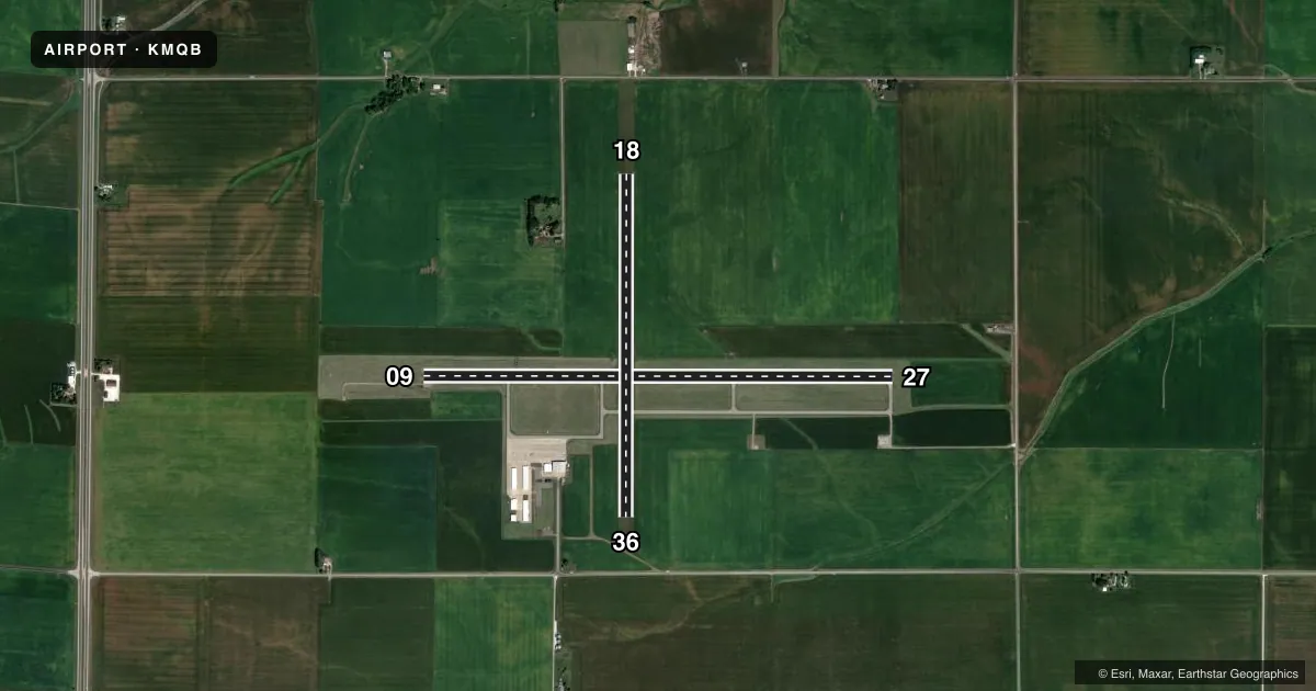
Runways & pattern
Full pagePattern entry · RWY 09
LEFT TRAFFIC| Runway | Heading (°M) | Length | Surface | Traffic |
|---|---|---|---|---|
| 09/27 | 89° / 269° | 5,100 ft | ASPH | Standard L |
| 18/36 | 179° / 359° | 3,719 ft | TURF | Standard L |
Runway end performance
| End | TORA | TODA | ASDA | LDA | VGSI | Approach lights | Obstruction |
|---|---|---|---|---|---|---|---|
| 09 | — | — | — | — | PAPI 4-box left(3°) | — | — |
| 27 | — | — | — | — | PAPI 4-box left(3°) | — | — |
Declared distances in feet. TORA = takeoff run available, TODA = takeoff distance, ASDA = accelerate-stop, LDA = landing distance.
Airport sketch
Runways drawn to scale from FAA survey coordinates, rendered over satellite imagery. Not for navigation.
Approaches & charts
ILS · 1
Services on the field
Fuel grades, oxygen, maintenance, ramp storage and lighting — as declared to the FAA by the airport operator.
Fuel & services
- Fuel
- 100LLA
- Oxygen (bottled)
- Not available
- Oxygen (bulk)
- Not available
- Airframe repair
- Major
- Power plant repair
- Major
- Other services
- AGRI,AMB,CHTR,INSTR,RNTL,SALES
Ramp & ground
- Transient storage
- Tie-down
- Hangar
- Landing fee
- No fee published
- Customs
- Not available
- Lighting schedule
- SEE RMK
- Beacon schedule
- SS-SR
- Beacon
- White / Green (civil land)(WG)
- Wind indicator
- Lighted
- Segmented circle
- No
Fuel & FBOs
Cheapest 100LL and Jet A on the field and nearby. Always confirm with the FBO before taxi.
Airport notes
Surface conditions, obstructions, local procedures, lighting outages and other notes published with each FAA cycle.
General notes
- FOR CD IF UNA TO CTC ON FSS FREQ, CTC CHICAGO ARTCC AT 630-906-8921.
Lighting notes
- HIRL RY 09/27 PRESET ON LOW INTST; TO INCR INTST & ACTVT REIL RY 09 & 27, AND TWY LGTS - CTAF.
Runway surface & condition
- 18/36RY 18/36 SEASONAL, NOV 1 - MAY 1 CTC AMGR 309-833-3324.
- 18/36TURF WIDTH 200 FT SOUTH OF INTERSECTION WITH RY 09/27.
Approach & departure obstructions
- 09PAPI UNUSBL BYD 8 DEGS RIGHT OF CNTRLN.
VFR map & nearby airports
VFR sectional. Tap any ICAO chip to open that airport.
Key facts · KMQB
Answer card- ICAO
- KMQB
- Name
- MACOMB MUNI
- Location
- MACOMB, ILLINOIS
- Elevation
- 705.7 ft MSL
- Traffic pattern altitude
- 1,705.7 ft MSL (1,000 AGL)
- Control tower
- Non-towered (use CTAF)
- Total runways
- 2
- Longest runway
- 09/27 · 5,100 ft
- Published ILS approaches
- 1
- Published frequencies
- 2
- Magnetic variation
- 1°
- Current flight rules
- VFR
- Current wind
- 000° at 0 kt
- Favored runway now
- –
Macomb Muni sits in Macomb, Illinois. The field elevation is 705.7 ft MSL. It has two runways. The longest is 09/27 at 5,100 ft on asphalt. Runway 18/36 is turf at 3,719 ft. The airport is not towered. CTAF and UNICOM are both 122.8.
There is one ILS approach to runway 27. The published pattern altitude is not listed, so use the standard 1,000 ft AGL for light piston ops unless the current Chart Supplement says otherwise. Jet Air, Inc. is on the field. It carries 100LL and Jet A with Prist. Call (309) 833-3324 for current service details.
A few published remarks matter for planning. The PAPI on runway 09 is unusable more than 8 degrees right of centerline. Runway 18/36 is seasonal. It is closed from November 1 to May 1. The turf width is 200 feet south of the intersection with runway 09/27. Runway 09/27 has high intensity lights preset to low. Use CTAF to raise intensity and bring on runway end identifier lights and taxiway lights. This is a non-towered field, so standard self-announce discipline matters. Check the current FAA Chart Supplement for any current restrictions before you go.