METAR & TAF KCLI
Current METAR
Observed 13:35Z
KCLI 271335Z AUTO 17007KT 7SM BR OVC006 26/24 A2975 RMK AO2 T02570243
- Wind
- 170° @ 7 kt
- Visibility
- 7 SM
- Temp / Dew
- 26°C / 24°C
- Altimeter
- 29.75 inHg
- Clouds
- OVC
- Density alt
- 2,555 ft
- Ceiling
- 600 ft AGL
- Rules
- IFR
Airport info & contacts
Manager on record, flight service, ARTCC, attendance schedule and pattern altitude — published by the FAA and refreshed every 28 days.
Location
- From city
- 1 NM SE
- VFR sectional
- GREEN BAY
- ARTCC
- ZMP · MINNEAPOLIS
- NOTAM facility
- CLI (NOTAM-D)
Airport manager
- Name
- CAZ MUSKE
- Phone
- (715) 250-0220
- Address
- 50 10TH ST, CLINTONVILLE WI 54929
Flight service · Hours
- FSS GRB
- GREEN BAY1-800-WX-BRIEF
- Attendance
- MON-FRI · 0800-1700
Frequencies
Tap any row to copy the frequency to your clipboard.
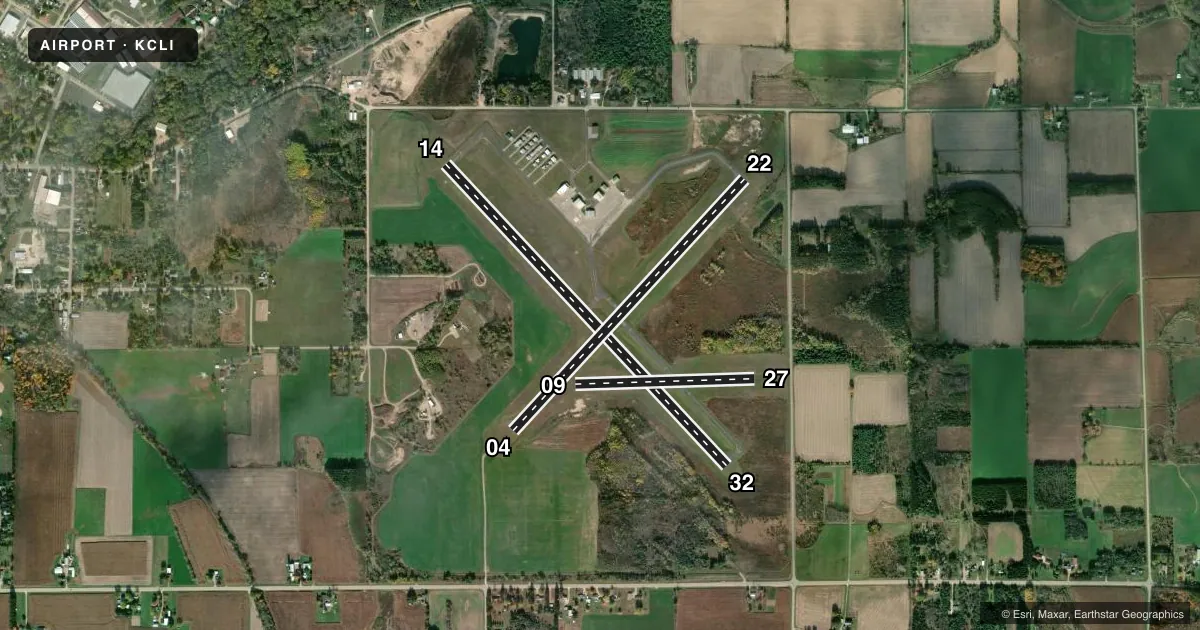
Runways & pattern
Full pagePattern entry · RWY 14
LEFT TRAFFIC| Runway | Heading (°M) | Length | Surface | Traffic |
|---|---|---|---|---|
| 14/32Favored | 135° / 315° | 4,599 ft | ASPH | Standard L |
| 04/22 | 41° / 221° | 3,812 ft | ASPH | Standard L |
| 09/27 | 87° / 266° | 2,002 ft | TURF | Standard L |
Runway end performance
| End | TORA | TODA | ASDA | LDA | VGSI | Approach lights | Obstruction |
|---|---|---|---|---|---|---|---|
| 14 | — | — | — | — | — | — | 79', trees, 1300' from thr, 375' R of cntrln, slope 13 |
| 32 | — | — | — | — | PAPI 2-box left(3°) | — | 37', trees, 355' from thr, 260' R of cntrln, slope 4 |
Declared distances in feet. TORA = takeoff run available, TODA = takeoff distance, ASDA = accelerate-stop, LDA = landing distance.
Airport sketch
Runways drawn to scale from FAA survey coordinates, rendered over satellite imagery. Not for navigation.
Approaches & charts
Services on the field
Fuel grades, oxygen, maintenance, ramp storage and lighting — as declared to the FAA by the airport operator.
Fuel & services
- Fuel
- 100LLA+
- Airframe repair
- Not available
- Power plant repair
- Not available
- Other services
- AVNCS,INSTR
Ramp & ground
- Transient storage
- Tie-down
- Hangar
- Landing fee
- No fee published
- Customs
- Not available
- Lighting schedule
- SEE RMK
- Beacon schedule
- SS-SR
- Beacon
- White / Green (civil land)(WG)
- Wind indicator
- Lighted
- Segmented circle
- No
Fuel & FBOs
Cheapest 100LL and Jet A on the field and nearby. Always confirm with the FBO before taxi.
Airport notes
Surface conditions, obstructions, local procedures, lighting outages and other notes published with each FAA cycle.
General notes
- DEER, FOX & BIRDS ON & INVOF ARPT.
- FOR CD CTC GREEN BAY APCH AT 920-431-5741. WHEN APCH CLSD, CTC MINNEAPOLIS ARTCC AT 651-463-5588.
Lighting notes
- MIRL RWY 04/22 & RWY 14/32 PRESET TO LOW SS-SR; TO INCR INTST & ACTVT REIL RWY 32; MIRL RWY 04/22 & 14/32 - CTAF. PAPI RWY 32 OPRS CONSLY.
Fuel notes
- 100LL24 HR SELF SVC FUEL AVBL WITH CREDIT CARD.
Runway surface & condition
- 09/27CLSD FM 1 DEC TO 15 APR; TO CONFIRM RWY COND OTR TIMES CTC AMGR.
Approach & departure obstructions
- 09MKD WITH WHITE CONES.
- 27MKD WITH WHITE CONES.
VFR map & nearby airports
VFR sectional. Tap any ICAO chip to open that airport.
Key facts · KCLI
Answer card- ICAO
- KCLI
- Name
- CLINTONVILLE MUNI
- Location
- CLINTONVILLE, WISCONSIN
- Elevation
- 825.9 ft MSL
- Traffic pattern altitude
- 1,825.9 ft MSL (1,000 AGL)
- Control tower
- Non-towered (use CTAF)
- Total runways
- 3
- Longest runway
- 14/32 · 4,599 ft
- Published ILS approaches
- 0
- Published frequencies
- 4
- Magnetic variation
- 2°
- Current flight rules
- IFR
- Current wind
- 170° at 7 kt
- Favored runway now
- RWY 14
Clintonville Muni sits in Clintonville, Wisconsin. Field elevation is 825.9 ft MSL. The airport has three runways. The longest is runway 14/32 at 4,599 ft. Runways 14/32 and 04/22 are asphalt. Runway 09/27 is turf.
This is an untowered field. CTAF and UNICOM are both 122.8. Green Bay Approach handles IFR services on 126.3 and 338.2. No ILS approaches are published here. Pattern altitude is not published, so use the standard 1,000 ft AGL for light piston operations unless the current Chart Supplement says otherwise.
The on-field FBO is Clintonville Municipal Airport. It carries 100LL and Jet A with Prist. Twenty-four hour self-service 100LL is available with credit card. Runway lighting on 04/22 and 14/32 is CTAF-controlled. The lights come up low from sunset to sunrise. Runway 32 end identifier lights can be activated with CTAF. The PAPI on runway 32 operates continuously. Runway 27 is marked with white cones. Runway 09 is marked with white cones.
Plan for wildlife on and near the airport. Deer, fox and birds are noted in the published remarks. Runway 09/27 is closed from December 1 to April 15. Check the current Chart Supplement or call the manager before using that strip outside the normal season. For clearance delivery, Green Bay Approach is the published contact. When approach is closed, Minneapolis ARTCC is the backup contact.