METAR & TAF KISQ
Current METAR
Observed 18:15Z
KISQ 271815Z AUTO 20013G25KT 9SM FEW003 24/19 A2969 RMK AO2 PRESRR
- Wind
- 200° @ 13G25 kt
- Visibility
- 9 SM
- Temp / Dew
- 24°C / 19°C
- Altimeter
- 29.69 inHg
- Clouds
- FEW
- Density alt
- 2,214 ft
- Ceiling
- Unlimited
- Rules
- VFR
Airport info & contacts
Manager on record, flight service, ARTCC, attendance schedule and pattern altitude — published by the FAA and refreshed every 28 days.
Location
- From city
- 3 NM NE
- VFR sectional
- GREEN BAY
- ARTCC
- ZMP · MINNEAPOLIS
- NOTAM facility
- ISQ (NOTAM-D)
Airport manager
- Name
- STEVE VIDETICH
- Phone
- 906-341-5522
- Address
- 5910 W US HIGHWAY 2, MANISTIQUE MI 49854
Flight service · Hours
- FSS GRB
- GREEN BAY1-800-WX-BRIEF
- Attendance
- MON-FRI · 0800-1500
Frequencies
Tap any row to copy the frequency to your clipboard.
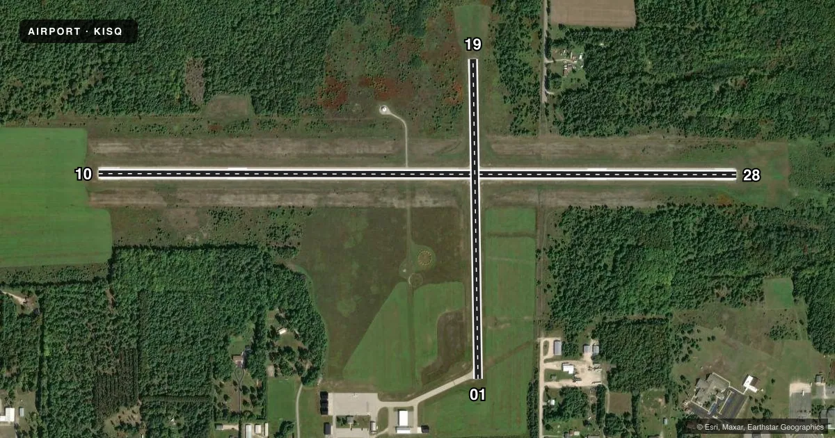
Runways & pattern
Full pagePattern entry · RWY 19
LEFT TRAFFIC| Runway | Heading (°M) | Length | Surface | Traffic |
|---|---|---|---|---|
| 10/28 | 85° / 265° | 5,001 ft | ASPH | Standard L |
| 01/19Favored | 354° / 174° | 2,501 ft | ASPH | Standard L |
Runway end performance
| End | TORA | TODA | ASDA | LDA | VGSI | Approach lights | Obstruction |
|---|---|---|---|---|---|---|---|
| 10 | — | — | — | — | PAPI 2-box left(3°) | — | 40', pline, 1200' from thr, 500' R of cntrln, slope 25 |
| 28 | — | — | — | — | PAPI 2-box left(3°) | — | 22', trees, 439' from thr, 280' R of cntrln, slope 10 |
Declared distances in feet. TORA = takeoff run available, TODA = takeoff distance, ASDA = accelerate-stop, LDA = landing distance.
Airport sketch
Runways drawn to scale from FAA survey coordinates, rendered over satellite imagery. Not for navigation.
Approaches & charts
Services on the field
Fuel grades, oxygen, maintenance, ramp storage and lighting — as declared to the FAA by the airport operator.
Fuel & services
- Fuel
- 100LLA+
- Oxygen (bottled)
- Not available
- Oxygen (bulk)
- Not available
- Airframe repair
- Not available
- Power plant repair
- Not available
Ramp & ground
- Transient storage
- Tie-down
- Landing fee
- No fee published
- Customs
- Not available
- Lighting schedule
- SEE RMK
- Beacon schedule
- SS-SR
- Beacon
- White / Green (civil land)(WG)
- Wind indicator
- Lighted
- Segmented circle
- Yes
Fuel & FBOs
Cheapest 100LL and Jet A on the field and nearby. Always confirm with the FBO before taxi.
Airport notes
Surface conditions, obstructions, local procedures, lighting outages and other notes published with each FAA cycle.
General notes
- DEER, BIRDS, & WILDLIFE ON & INVOF ARPT.
- RWY 19: 100 FT UNMARKED PLINE, 1 MI NORTH OF RWY END.
- FOR CD IF UNA TO CTC ON FSS FREQ, CTC MINNEAPOLIS ARTCC AT 651-463-5588.
Lighting notes
- ACTVT REIL RWY 28; PAPI RWY 10 & 28; MIRL RWY 10/28 - CTAF.
Runway surface & condition
- 01/19UNLGTD & NO REFLECTORS.
Approach & departure obstructions
- 01ALSO +15 FT ROAD, 659 FT DIST, 30:1.
- 10ALSO +40 FT PLINE, 1200 FT DIST, 25:1.
VFR map & nearby airports
VFR sectional. Tap any ICAO chip to open that airport.
Key facts · KISQ
Answer card- ICAO
- KISQ
- Name
- SCHOOLCRAFT COUNTY
- Location
- MANISTIQUE, MICHIGAN
- Elevation
- 684.3 ft MSL
- Traffic pattern altitude
- 1,684.3 ft MSL (1,000 AGL)
- Control tower
- Non-towered (use CTAF)
- Total runways
- 2
- Longest runway
- 10/28 · 5,001 ft
- Published ILS approaches
- 0
- Published frequencies
- 2
- Magnetic variation
- 5°
- Current flight rules
- VFR
- Current wind
- 200° at 13 kt
- Favored runway now
- RWY 19
Schoolcraft County Airport sits in Manistique, Michigan. Field elevation is 684.3 ft MSL. The airport has two asphalt runways. The longest is runway 10/28 at 5,001 ft. There is no control tower. CTAF and UNICOM are both 122.8.
No ILS approaches are published here. Runway 10/28 is the main lit runway. Runway 28 has REILs. Runways 10 and 28 have PAPI and medium intensity runway lights. Runways 01 and 19 are unlighted and have no reflectors. Pattern altitude is not published, so use the standard 1,000 ft AGL for light piston operations unless the current FAA Chart Supplement says otherwise.
Schoolcraft County Airport is the on-field FBO. It carries AVGAS 100LL and Jet A with Prist. Call (906) 341-5522 before arrival if you need current service details. The published remarks also call out wildlife on and near the airport. That matters here. Expect deer and birds. There is also a road obstruction near the departure end of runway 01. A power line is published near the departure end of runway 10. Runway 19 also has an unmarked power line one mile north of the runway end. If you are planning a night or low-vis arrival, verify the lighting setup and current remarks in the FAA Chart Supplement before you go.