METAR & TAF KSUE
Current METAR
Observed 16:57Z
KSUE 271657Z AUTO 18009KT 10SM VCTS RA FEW013 SCT029 OVC038 19/19 A2971 RMK AO2 WSHFT 1620 LTG DSNT ALQDS SLP057 P0041 T01940189 $
- Wind
- 180° @ 9 kt
- Visibility
- 10 SM
- Temp / Dew
- 19°C / 19°C
- Altimeter
- 29.71 inHg
- Clouds
- OVC
- Density alt
- 1,638 ft
- Ceiling
- 3,800 ft AGL
- Rules
- VFR
Airport info & contacts
Manager on record, flight service, ARTCC, attendance schedule and pattern altitude — published by the FAA and refreshed every 28 days.
Location
- From city
- 2 NM W
- VFR sectional
- GREEN BAY
- ARTCC
- ZMP · MINNEAPOLIS
- NOTAM facility
- SUE (NOTAM-D)
Airport manager
- Name
- CRAIG ROSS
- Phone
- 920-746-7131
- Address
- 3538 PARK DR DOOR CO ARPT, STURGEON BAY WI 54235
Flight service · Hours
- FSS GRB
- GREEN BAY1-800-WX-BRIEF
- Attendance
- MON-SAT · 0800-1800
- SUN · 0800-1600
Frequencies
Tap any row to copy the frequency to your clipboard.
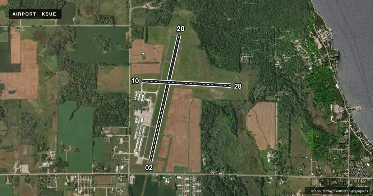
Runways & pattern
Full pagePattern entry · RWY 20
LEFT TRAFFIC| Runway | Heading (°M) | Length | Surface | Traffic |
|---|---|---|---|---|
| 02/20Favored | 10° / 190° | 4,599 ft | ASPH | Standard L |
| 10/28 | 90° / 270° | 3,199 ft | ASPH | Standard L |
Runway end performance
| End | TORA | TODA | ASDA | LDA | VGSI | Approach lights | Obstruction |
|---|---|---|---|---|---|---|---|
| 02 | — | — | — | — | PAPI 4-box left(3°) | RLLS | — |
| 20 | — | — | — | — | PAPI 4-box left(3°) | — | — |
| 10 | — | — | — | — | PAPI 4-box left(3°) | — | — |
| 28 | — | — | — | — | PAPI 4-box left(3°) | — | — |
Declared distances in feet. TORA = takeoff run available, TODA = takeoff distance, ASDA = accelerate-stop, LDA = landing distance.
Airport sketch
Runways drawn to scale from FAA survey coordinates, rendered over satellite imagery. Not for navigation.
Approaches & charts
Services on the field
Fuel grades, oxygen, maintenance, ramp storage and lighting — as declared to the FAA by the airport operator.
Fuel & services
- Fuel
- 100LLA+
- Airframe repair
- Minor
- Power plant repair
- Minor
- Other services
- CHTR,INSTR,RNTL
Ramp & ground
- Transient storage
- Tie-down
- Hangar
- Landing fee
- No fee published
- Customs
- Not available
- Lighting schedule
- SEE RMK
- Beacon schedule
- SS-SR
- Beacon
- White / Green (civil land)(WG)
- Wind indicator
- Lighted
- Segmented circle
- No
Fuel & FBOs
Cheapest 100LL and Jet A on the field and nearby. Always confirm with the FBO before taxi.
Airport notes
Surface conditions, obstructions, local procedures, lighting outages and other notes published with each FAA cycle.
General notes
- WILDLIFE ON & INVOF ARPT.
- BE ALERT: NO LINE OF SIGHT RY 02 TO 20.
- GROUP OF SIX TWRS APRXLY 4 NM NE-TALLEST TWR IS 1351 FT MSL/499 FT AGL.
- ULTRALIGHT ACTIVITY ON & INVOF ARPT.
- FOR CD CTC GREEN BAY APCH ON FREQ OR 920-431-5741, WHEN APCH CLSD, CTC MINNEAPOLIS ARTCC AT 651-463-5588.
Lighting notes
- MIRL RWY 10/28 PRESET TO LOW SS-SR; TO INCR INTST AND ACTVT RLLS RWY 02; REIL RWY 02, 10, 20 & 28; PAPI RWY 02, 10, 20 & 28; MIRL RWY 02/20, MIRL 10/28 - CTAF.
Fuel notes
- 100LL24 HR FUEL AVBL WITH CREDIT CARD.
Other notes
- 1AFT HRS CALL 920-746-2581.
VFR map & nearby airports
VFR sectional. Tap any ICAO chip to open that airport.
Key facts · KSUE
Answer card- ICAO
- KSUE
- Name
- DOOR COUNTY CHERRYLAND
- Location
- STURGEON BAY, WISCONSIN
- Elevation
- 724.2 ft MSL
- Traffic pattern altitude
- 1,724.2 ft MSL (1,000 AGL)
- Control tower
- Non-towered (use CTAF)
- Total runways
- 2
- Longest runway
- 02/20 · 4,599 ft
- Published ILS approaches
- 0
- Published frequencies
- 4
- Magnetic variation
- 3°
- Current flight rules
- VFR
- Current wind
- 180° at 9 kt
- Favored runway now
- RWY 20
Door County Cherryland Airport sits in Sturgeon Bay, Wisconsin. Field elevation is 724.2 ft MSL. It has two asphalt runways. The longest is 4,599 ft. There is no control tower. Pattern altitude is not published, so use the standard 1,000 ft AGL for light piston aircraft unless current local guidance says otherwise.
No ILS approaches are published here. CTAF and UNICOM are both 122.7. Green Bay Approach handles clearance delivery and approach or departure services on 119.25 or 338.2. When approach is closed, Minneapolis ARTCC handles clearances by phone. The field is set up for straightforward VFR work, but you should pay attention to the published remarks. Wildlife is on and near the airport. Ultralight activity is also reported in the area. There is also no line of sight between runway 02 and runway 20, so do not assume you can see traffic or runway occupancy from one end to the other.
Tailwind Flight Center is on the field. It carries 100LL, Jet A and Jet A Prist. 24-hour fuel is available with credit card. After hours, call the FBO directly. Runway lighting is CTAF controlled. Runway 10/28 lights come up low from sunset to sunrise. Use runway 02 to increase intensity and activate the lights.