METAR & TAF 1C1
1C1 does not publish a METAR.
Showing the nearest reporting station: KTIP (RANTOUL NTL AVN CNTR-FRANK ELLIOTT FLD) · 9.4 NM away. Conditions at 1C1 may differ.
METAR · KTIP
Observed 00:15Z
KTIP 120015Z AUTO 20019G25KT 10SM SCT110 29/23 A2967 RMK AO2 T02940230
- Wind
- 200° @ 19G25 kt
- Visibility
- 10 SM
- Temp / Dew
- 29°C / 23°C
- Altimeter
- 29.67 inHg
- Clouds
- SCT
- Density alt
- 2,956 ft
- Ceiling
- Unlimited
- Rules
- VFR
Airport info & contacts
Manager on record, flight service, ARTCC, attendance schedule and pattern altitude — published by the FAA and refreshed every 28 days.
Location
- From city
- 2 NM SW
- VFR sectional
- CHICAGO
- Pattern altitude
- 800 ft AGL · 1,579 ft MSL
- ARTCC
- ZAU · CHICAGO
- NOTAM facility
- STL (NOTAM-D)
Airport manager
- Name
- DOMINIQUE, YOUAKIM
- Phone
- 217-234-9439
- Address
- 482 AIRPORT ROAD, BUILDING G, MATOON IL 61938
Flight service · Hours
- FSS STL
- SAINT LOUIS1-800-WX-BRIEF
- Attendance
- IREG
Frequencies
Tap any row to copy the frequency to your clipboard.
Runways & pattern
Full pagePattern entry · RWY 18
LEFT TRAFFICRunway end performance
| End | TORA | TODA | ASDA | LDA | VGSI | Approach lights | Obstruction |
|---|---|---|---|---|---|---|---|
| 18 | — | — | — | — | — | — | 56', tree, 601' from thr, 85' R of cntrln, slope 7 |
| 36 | — | — | — | — | TRIL(3°) | — | — |
Declared distances in feet. TORA = takeoff run available, TODA = takeoff distance, ASDA = accelerate-stop, LDA = landing distance.
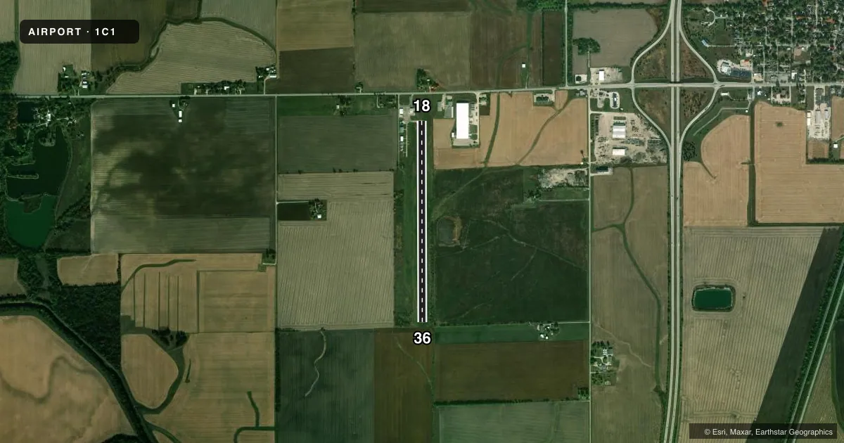
Airport sketch
Runways drawn to scale from FAA survey coordinates, rendered over satellite imagery. Not for navigation.
Approaches & charts
Services on the field
Fuel grades, oxygen, maintenance, ramp storage and lighting — as declared to the FAA by the airport operator.
Fuel & services
- Fuel
- 100LLA
- Oxygen (bottled)
- Not available
- Oxygen (bulk)
- Not available
- Airframe repair
- Not available
- Power plant repair
- Not available
- Other services
- AGRI
Ramp & ground
- Transient storage
- Tie-down
- Hangar
- Landing fee
- No fee published
- Lighting schedule
- SS-SR
- Beacon schedule
- SS-SR
- Beacon
- White / Green (civil land)(WG)
- Wind indicator
- Lighted
- Segmented circle
- No
Fuel & FBOs
Cheapest 100LL and Jet A on the field and nearby. Always confirm with the FBO before taxi.
Airport notes
Surface conditions, obstructions, local procedures, lighting outages and other notes published with each FAA cycle.
General notes
- AFT HR ACES TO AP TERM VIA CIPHER LOCK HINT TO COMBO POSTED.
- FOR CD CTC CHAMPAIGN APCH AT 217-355-4071, WHEN APCH CLSD CTC CHICAGO ARTCC AT 630-906-8921
- SUMMER AG OPS.
Fuel notes
- 100LLSELF SERVE 100LL AND JET A
Runway surface & condition
- 18/36NSTD LIRL - FIXTURE SPACING & LGT INTSTY VARIES.
Approach & departure obstructions
- 1820 FT BLDG 120 FT FM RWY END AND 130 FT R OF CNTRLN.
- 18DTHR PAINTED WHITE LINE ACRS RWY.
- 18RWY 18 MARKINGS FADED.
- 36RWY 36 MARKINGS FADED.
- 18APCH RATIO 25:1 TO DTHR.
Other notes
- THIS AIRPORT HAS BEEN SURVEYED BY THE NATIONAL GEODETIC SURVEY.
- ALL OPNS TO BE CONDD ON E SIDE OF N/S RWY.
- 18/36RWY 18/36 HAS WIDESPREAD CRACKING WITH VEGETATION GROWING IN CRACKS.
VFR map & nearby airports
VFR sectional. Tap any ICAO chip to open that airport.
Key facts · 1C1
Answer card- ICAO
- 1C1
- Name
- PAXTON
- Location
- PAXTON, ILLINOIS
- Elevation
- 779 ft MSL
- Traffic pattern altitude
- 1,579 ft MSL (800 AGL)
- Control tower
- Non-towered (use CTAF)
- Total runways
- 1
- Longest runway
- 18/36 · 3,409 ft
- Published ILS approaches
- 0
- Published frequencies
- 4
- Magnetic variation
- 3°
- Current flight rules
- VFR
- Current wind
- 200° at 19 kt
- Favored runway now
- RWY 18
Paxton Airport sits in Paxton, Illinois. Field elevation is 779 ft MSL. The airport has one runway. Runway 18/36 is 3,409 ft long with asphalt pavement. There is no control tower. The pattern altitude is 800 ft AGL, which is 1,579 ft MSL.
No ILS approaches are published here. For clearance delivery, contact Champaign Approach. When approach is closed, contact Chicago ARTCC. The field has self-serve 100LL and Jet A available. Paxton Airport is the only on-field FBO listed. Call ahead at (217) 379-4022 to confirm current service details before you go.
A few published remarks matter for planning. Nonstandard low-intensity runway lights are installed, so light spacing and brightness may vary. Runway 18 has a displaced threshold marked by a painted white line. Runway 18 and Runway 36 both have faded markings. Runway 18 also has a building near the departure end that sits close to the extended centerline. All operations are to be conducted on the east side of the north-south runway. Summer agricultural operations occur, so expect local traffic and field activity in season.