METAR & TAF KDNV
Current METAR
Observed 14:50Z
KDNV 271450Z AUTO 25010G17KT 2 1/2SM CLR 30/24 A2988 RMK AO2 T02990243
- Wind
- 250° @ 10G17 kt
- Visibility
- 0.5 SM
- Temp / Dew
- 30°C / 24°C
- Altimeter
- 29.88 inHg
- Clouds
- CLR
- Density alt
- 2,714 ft
- Ceiling
- Unlimited
- Rules
- LIFR
Airport info & contacts
Manager on record, flight service, ARTCC, attendance schedule and pattern altitude — published by the FAA and refreshed every 28 days.
Location
- From city
- 4 NM NE
- VFR sectional
- CHICAGO
- ARTCC
- ZAU · CHICAGO
- NOTAM facility
- DNV (NOTAM-D)
Airport manager
- Name
- TESS COOK
- Phone
- 217-442-4624
- Address
- 22633 N. BOWMAN AVE., SUITE 1, DANVILLE IL 61834
Flight service · Hours
- FSS STL
- SAINT LOUIS1-800-WX-BRIEF
- Attendance
- 0700-2200
Frequencies
Tap any row to copy the frequency to your clipboard.
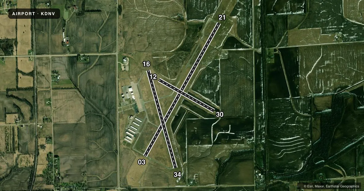
Runways & pattern
Full pagePattern entry · RWY 21
LEFT TRAFFIC| Runway | Heading (°M) | Length | Surface | Traffic |
|---|---|---|---|---|
| 03/21Favored | 28° / 208° | 6,006 ft | ASPH | Standard L |
| 16/34 | 163° / 343° | 3,999 ft | ASPH | Standard L |
| 12/30 | 118° / 298° | 2,500 ft | TURF | Standard L |
Runway end performance
| End | TORA | TODA | ASDA | LDA | VGSI | Approach lights | Obstruction |
|---|---|---|---|---|---|---|---|
| 03 | — | — | — | — | VASI 4-box left(3°) | — | 39', tree, 1529' from thr, 0' R of cntrln, slope 34 |
| 21 | — | — | — | — | PAPI 4-box left(3°) | MALSR | — |
| 16 | — | — | — | — | VASI 2-box left(3°) | — | — |
| 34 | — | — | — | — | VASI 2-box left(3°) | — | — |
Declared distances in feet. TORA = takeoff run available, TODA = takeoff distance, ASDA = accelerate-stop, LDA = landing distance.
Airport sketch
Runways drawn to scale from FAA survey coordinates, rendered over satellite imagery. Not for navigation.
Approaches & charts
ILS · 1
Services on the field
Fuel grades, oxygen, maintenance, ramp storage and lighting — as declared to the FAA by the airport operator.
Fuel & services
- Fuel
- 100LLA
- Oxygen (bottled)
- Not available
- Oxygen (bulk)
- Not available
- Airframe repair
- Major
- Power plant repair
- Major
- Other services
- AFRT,AGRI,AVNCS,CARGO,CHTR,GLD,INSTR,TOW
Ramp & ground
- Transient storage
- Tie-down
- Hangar
- Landing fee
- No fee published
- Customs
- Not available
- Lighting schedule
- SEE RMK
- Beacon schedule
- SS-SR
- Beacon
- White / Green (civil land)(WG)
- Wind indicator
- Lighted
Fuel & FBOs
Cheapest 100LL and Jet A on the field and nearby. Always confirm with the FBO before taxi.
Airport notes
Surface conditions, obstructions, local procedures, lighting outages and other notes published with each FAA cycle.
General notes
- EXTSV GLDR OPS WKENDS.
- FOR CD IF UNABLE VIA RADIO CTC CHAMPAIGN APCH AT 217-355-4071, WHEN APCH CLSD CTC CHICAGO ARTCC AT 630-906-8921
- AIR CARGO PART 135 FLT DEPS NGTLY 2200, ARRS DLY 0600 MON THRU SAT.
Lighting notes
- HIRL RWY 03/21 PRESET LOW INTST - TO INCR INTST & ACTVT MALSR RWY 21; VASI RWYS 03, 16 & 34; PAPI RWY 21; MIRL RWY 16/34 - CTAF.
Runway surface & condition
- 12/30SEASONAL RWY NOV 1 - MAY 1; CTC AMGR 217-442-4624.
Other notes
- MANAGEREMAIL ADDRESS: MANAGER@VRAIRPORT.COM
- MANAGERROD HIGHTOWER
VFR map & nearby airports
VFR sectional. Tap any ICAO chip to open that airport.
Key facts · KDNV
Answer card- ICAO
- KDNV
- Name
- VERMILION RGNL
- Location
- DANVILLE, ILLINOIS
- Elevation
- 696.9 ft MSL
- Traffic pattern altitude
- 1,696.9 ft MSL (1,000 AGL)
- Control tower
- Non-towered (use CTAF)
- Total runways
- 3
- Longest runway
- 03/21 · 6,006 ft
- Published ILS approaches
- 1
- Published frequencies
- 5
- Magnetic variation
- 1°
- Current flight rules
- LIFR
- Current wind
- 250° at 10 kt
- Favored runway now
- RWY 21
Vermilion Regional Airport sits in Danville, Illinois. Field elevation is 696.9 ft MSL. The airport has three runways. The longest is runway 03/21 at 6,006 ft. There is no control tower, so plan for CTAF traffic and self-announced coordination. Pattern altitude is not published. Use the standard 1,000 ft AGL for light piston traffic unless the current FAA Chart Supplement says otherwise. That puts the pattern at about 1,697 ft MSL.
Runway 21 has the published ILS. Runways 03, 16 and 34 have visual glide path aids. Runway 03/21 uses high intensity lighting that starts at low intensity. Use CTAF to raise the lights and activate the MALSR for runway 21. Runway 16/34 has medium intensity lights controlled by CTAF. Runway 12/30 is turf and seasonal from November 1 to May 1. Expect to verify its status before you launch.
Midwest Aero Restorations is on the field. It carries 100LL and Jet A. Weekend glider activity is extensive, so keep a sharp scan in the pattern. Air cargo Part 135 departures occur nightly at 2200. Arrivals occur daily at 0600 Monday through Saturday. If you need clearance delivery and cannot reach it by radio, contact Champaign Approach. When Approach is closed, contact Chicago ARTCC. First-time visitors should also note the airport sits in central Illinois with a mix of paved and turf operations. Runway selection matters.