METAR & TAF KTIP
Current METAR
Observed 00:15Z
KTIP 120015Z AUTO 20019G25KT 10SM SCT110 29/23 A2967 RMK AO2 T02940230
- Wind
- 200° @ 19G25 kt
- Visibility
- 10 SM
- Temp / Dew
- 29°C / 23°C
- Altimeter
- 29.67 inHg
- Clouds
- SCT
- Density alt
- 2,905 ft
- Ceiling
- Unlimited
- Rules
- VFR
Airport info & contacts
Manager on record, flight service, ARTCC, attendance schedule and pattern altitude — published by the FAA and refreshed every 28 days.
Location
- From city
- 0 NM N
- VFR sectional
- CHICAGO
- ARTCC
- ZAU · CHICAGO
- NOTAM facility
- TIP (NOTAM-D)
Airport manager
- Name
- BOB COVERDILL
- Phone
- 217-892-6895
- Address
- 333 S. TANNER, P.O BOX 38, RANTOUL IL 61866-0038
Flight service · Hours
- FSS STL
- SAINT LOUIS1-800-WX-BRIEF
- Attendance
- MON-FRI · 0700-1600
Frequencies
Tap any row to copy the frequency to your clipboard.
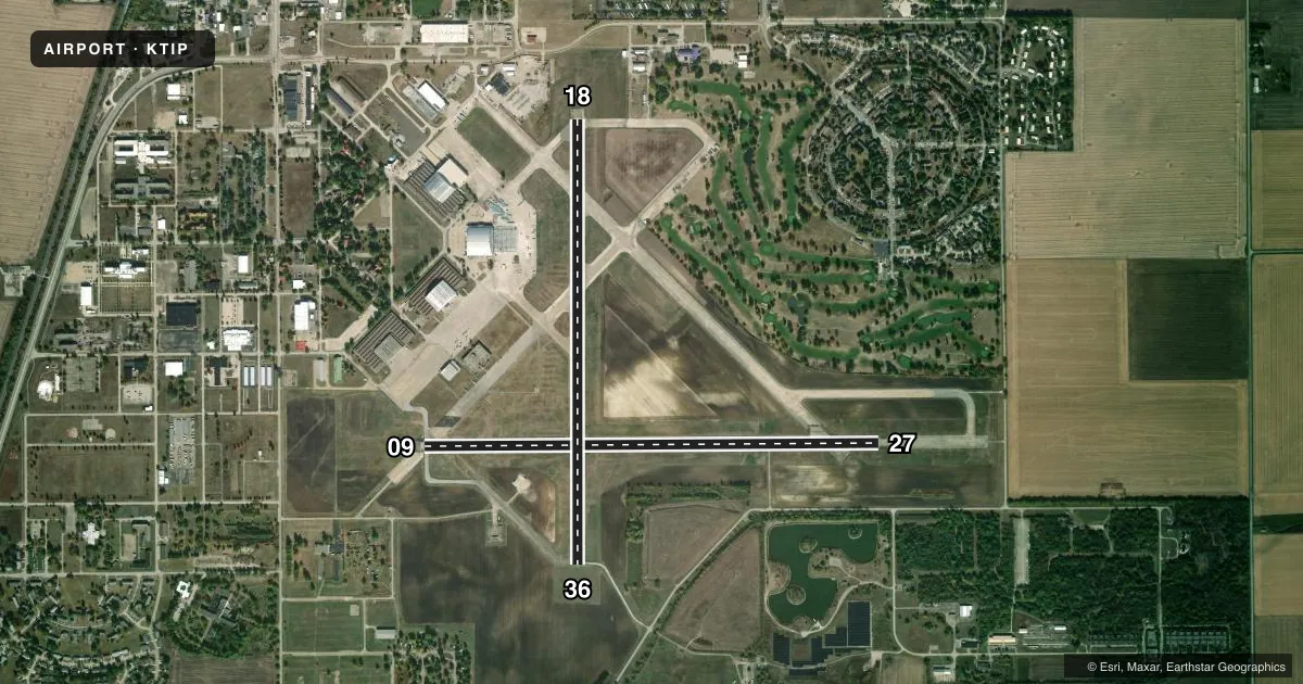
Runways & pattern
Full pagePattern entry · RWY 18
LEFT TRAFFIC| Runway | Heading (°M) | Length | Surface | Traffic |
|---|---|---|---|---|
| 09/27 | 89° / 269° | 5,001 ft | ASPH | 09 R |
| 18/36Favored | 179° / 359° | 4,894 ft | ASPH | 36 R |
Runway end performance
| End | TORA | TODA | ASDA | LDA | VGSI | Approach lights | Obstruction |
|---|---|---|---|---|---|---|---|
| 09 | — | — | — | — | PAPI 4-box left(3°) | — | — |
| 27 | — | — | — | — | PAPI 4-box left(3°) | — | — |
Declared distances in feet. TORA = takeoff run available, TODA = takeoff distance, ASDA = accelerate-stop, LDA = landing distance.
Airport sketch
Runways drawn to scale from FAA survey coordinates, rendered over satellite imagery. Not for navigation.
Approaches & charts
Services on the field
Fuel grades, oxygen, maintenance, ramp storage and lighting — as declared to the FAA by the airport operator.
Fuel & services
- Fuel
- 100LLA
- Oxygen (bottled)
- Not available
- Oxygen (bulk)
- Not available
- Airframe repair
- Not available
- Power plant repair
- Not available
- Other services
- AFRT,AGRI,CHTR,GLD,INSTR,RNTL,SALES
Ramp & ground
- Transient storage
- Hangar
- Landing fee
- No fee published
- Lighting schedule
- SEE RMK
- Beacon schedule
- SS-SR
- Beacon
- White / Green (civil land)(WG)
- Wind indicator
- Yes
- Segmented circle
- Yes
Fuel & FBOs
Cheapest 100LL and Jet A on the field and nearby. Always confirm with the FBO before taxi.
Airport notes
Surface conditions, obstructions, local procedures, lighting outages and other notes published with each FAA cycle.
General notes
- FBO OPNS MON-FRI 0700-1600. FBO SVC CLSD SAT+SUN UNLESS ADVN COORDINATION IS MADE.
- DEER & BIRDS ON AND INVOF ARPT. SEASONAL MOWING OPS ADJ TO RYS & TWYS.
- TWY 35 FT WIDE IN MOST PLACES. 48 HRS PPR FOR ACFT WITH SINGLE WHEEL LOAD GREATER THAN 15,000 LBS.
- FOR CD CTC CHAMPAIGN APCH AT 217-355-4071, WHEN APCH CLSD CTC CHICAGO ARTCC AT 630-906-8921
Lighting notes
- TO INCR INTST & ACTVT MIRL RYS 09/27 & 18/36, REILS RYS 09/27 - CTAF. PAPI RY 09 & 27 OPR CONTINUOUSLY.
Fuel notes
- 100LLFOR FUEL AFTER HRS CALL PHONE NUMBER POSTED ON SITE.
VFR map & nearby airports
VFR sectional. Tap any ICAO chip to open that airport.
Key facts · KTIP
Answer card- ICAO
- KTIP
- Name
- RANTOUL NTL AVN CNTR-FRANK ELLIOTT FLD
- Location
- RANTOUL, ILLINOIS
- Elevation
- 737.9 ft MSL
- Traffic pattern altitude
- 1,737.9 ft MSL (1,000 AGL)
- Control tower
- Non-towered (use CTAF)
- Total runways
- 2
- Longest runway
- 09/27 · 5,001 ft
- Published ILS approaches
- 0
- Published frequencies
- 4
- Magnetic variation
- 1°
- Current flight rules
- VFR
- Current wind
- 200° at 19 kt
- Favored runway now
- RWY 18
Rantoul Ntl Avn Cntr-Frank Elliott Fld is in Rantoul, Illinois. The field elevation is 737.9 ft MSL. It has two asphalt runways. The longest is 09/27 at 5,001 ft. There is no control tower. Pattern altitude is not published, so use the standard 1,000 ft AGL for light piston operations unless the current Chart Supplement says otherwise.
No ILS approaches are published here. CTAF and UNICOM are both 123.0. Approach and departure service is listed on 121.35 and 285.65 through Champaign. The on-field FBO is Rantoul National Aviation Center. It carries 100LL and Jet A Prist. The FBO is open Monday through Friday from 0700 to 1600. Weekend service is closed unless you arrange it ahead of time. For after-hours fuel, use the phone number posted on site.
A few operational items matter here. Runway lights and runway end identifier lights on 09/27 can be turned up with the CTAF. The PAPI on 09 and 27 runs continuously. Clearance delivery goes through Champaign Approach when it is open. When it is closed, use Chicago ARTCC. Deer and birds are reported on and near the airport. Seasonal mowing can also affect areas next to the runways and taxiways. Taxiways are 35 feet wide in most places. Aircraft with a single wheel load over 15,000 pounds need 48 hours prior permission.