METAR & TAF 2H0
2H0 does not publish a METAR.
Showing the nearest reporting station: KTAZ (TAYLORVILLE MUNI) · 23.6 NM away. Conditions at 2H0 may differ.
METAR · KTAZ
Observed 20:28Z
KTAZ 092028Z AUTO 22007KT 10SM VCTS SCT033 SCT050 BKN070 29/24 A2989 RMK AO2 LTG DSNT SE THRU W
- Wind
- 220° @ 7 kt
- Visibility
- 10 SM
- Temp / Dew
- 29°C / 24°C
- Altimeter
- 29.89 inHg
- Clouds
- BKN
- Density alt
- 2,485 ft
- Ceiling
- 7,000 ft AGL
- Rules
- VFR
Airport info & contacts
Manager on record, flight service, ARTCC, attendance schedule and pattern altitude — published by the FAA and refreshed every 28 days.
Location
- From city
- 3 NM W
- VFR sectional
- ST LOUIS
- Pattern altitude
- 800 ft AGL · 1,419 ft MSL
- ARTCC
- ZKC · KANSAS CITY
- NOTAM facility
- STL (NOTAM-D)
Airport manager
- Name
- SCOTT JEFSON
- Phone
- 217-774-5111
- Address
- 1147 N 1915 EAST ROAD, SHELBYVILLE IL 62565
Flight service · Hours
- FSS STL
- SAINT LOUIS1-800-WX-BRIEF
- Attendance
- 0800-DUSK
Frequencies
Tap any row to copy the frequency to your clipboard.
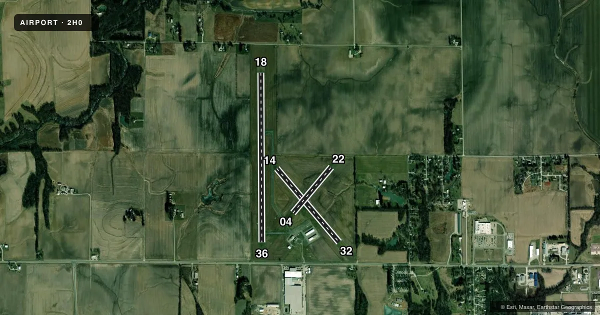
Runways & pattern
Full pagePattern entry · RWY 22
LEFT TRAFFIC| Runway | Heading (°M) | Length | Surface | Traffic |
|---|---|---|---|---|
| 18/36 | 178° / 358° | 4,098 ft | ASPH | Standard L |
| 14/32 | 138° / 318° | 2,336 ft | TURF | Standard L |
| 04/22Favored | 38° / 218° | 1,446 ft | TURF | Standard L |
Runway end performance
| End | TORA | TODA | ASDA | LDA | VGSI | Approach lights | Obstruction |
|---|---|---|---|---|---|---|---|
| 36 | — | — | — | — | PAPI 2-box left(4°) | — | — |
| 32 | — | — | — | — | — | — | 42', tree, 688' from thr, 140' R of cntrln, slope 16 |
Declared distances in feet. TORA = takeoff run available, TODA = takeoff distance, ASDA = accelerate-stop, LDA = landing distance.
Airport sketch
Runways drawn to scale from FAA survey coordinates, rendered over satellite imagery. Not for navigation.
Approaches & charts
Services on the field
Fuel grades, oxygen, maintenance, ramp storage and lighting — as declared to the FAA by the airport operator.
Fuel & services
- Fuel
- 100LLA+
- Oxygen (bottled)
- Not available
- Oxygen (bulk)
- Not available
- Airframe repair
- Major
- Power plant repair
- Major
Ramp & ground
- Transient storage
- Tie-down
- Hangar
- Landing fee
- No fee published
- Customs
- Not available
- Lighting schedule
- SEE RMK
- Beacon schedule
- SS-SR
- Beacon
- White / Green (civil land)(WG)
- Wind indicator
- Lighted
- Segmented circle
- No
Fuel & FBOs
Cheapest 100LL and Jet A on the field and nearby. Always confirm with the FBO before taxi.
Airport notes
Surface conditions, obstructions, local procedures, lighting outages and other notes published with each FAA cycle.
General notes
- BOUNDARIES FOR RYS 4/22 & 14/32 ARE MARKED WITH WHITE PAINTED TIRES SPACED AT 400 FT INTERVALS.
- RY 4 RELOCATED THLD NE OF TWYS. NEW RY LENGTHS PENDING RY 4/22.
- WHEN ARPT UNATNDD, PHONE NR FOR ASSISTANCE POSTED ON FBO DOORS.
- FOR CD CTC KANSAS CITY ARTCC AT 913-254-8508.
- WEATHER AVBL 4 CLICKS ON CTAF, SAY WEATHER.
Lighting notes
- ACTVT PAPI RWY 36; MIRL 18/36 - CTAF.
Fuel notes
- 100LLSELF SVC FUEL AVBL 24 HRS WITH CREDIT CARD.
Approach & departure obstructions
- 32APCH RATIO 20:1 TO DSPLCD THLD; 33 FT ANT 665 FT FM DSPLCD THLD 179 FT L OF CNTRLN.
Other notes
- RWY 4/22 NOT ANALYZED ESTAB PRIOR TO 1959.
- MANAGEREMAIL ADDRESS: SCOTTJEFSON@GMAIL.COM
- MANAGERALTERNATE PHONE NUMBER: 217-827-1196
VFR map & nearby airports
VFR sectional. Tap any ICAO chip to open that airport.
Key facts · 2H0
Answer card- ICAO
- 2H0
- Name
- SHELBY COUNTY
- Location
- SHELBYVILLE, ILLINOIS
- Elevation
- 618.9 ft MSL
- Traffic pattern altitude
- 1,418.9 ft MSL (800 AGL)
- Control tower
- Non-towered (use CTAF)
- Total runways
- 3
- Longest runway
- 18/36 · 4,098 ft
- Published ILS approaches
- 0
- Published frequencies
- 2
- Magnetic variation
- 2°
- Current flight rules
- VFR
- Current wind
- 220° at 7 kt
- Favored runway now
- RWY 22
Shelby County Airport sits in Shelbyville, Illinois. The field elevation is 618.9 ft MSL. It has three runways. The longest is runway 18/36 at 4,098 ft on asphalt. There is no control tower, so pilots use CTAF and UNICOM 122.8 for traffic calls and weather. Pattern altitude is 800 ft AGL. That is 1,418.9 ft MSL.
No ILS approaches are published here. If you need instrument details, check the current FAA Chart Supplement before you go. The airport has one on-field FBO listed as Shelby County Airport. It carries AVGAS 100LL and JET A PRIST. Self-service 100LL is available 24 hours with credit card. That is useful for late arrivals or early departures.
A few published remarks matter for planning. Runway 18 has medium intensity lights that are controlled on CTAF. The PAPI for runway 36 is activated from the radio. There is also an antenna near the displaced threshold area for runway 18. Runway 4/22 and 14/32 are turf. The turf runway boundaries are marked with white painted tires spaced at 400 ft intervals. For clearance delivery, contact Kansas City Center. If the field is unattended, the assistance number is posted on the FBO doors.