METAR & TAF 2T2
2T2 does not publish a METAR.
Showing the nearest reporting station: KFOA (FLORA MUNI) · 21.4 NM away. Conditions at 2T2 may differ.
METAR · KFOA
Observed 06:55Z
KFOA 270655Z AUTO 15006KT 1 3/4SM +RA BR BKN011 BKN021 OVC036 23/22 A2988 RMK AO2 P0037
- Wind
- 150° @ 6 kt
- Visibility
- 0.75 SM
- Temp / Dew
- 23°C / 22°C
- Altimeter
- 29.88 inHg
- Clouds
- OVC
- Density alt
- 1,694 ft
- Ceiling
- 1,100 ft AGL
- Rules
- LIFR
Airport info & contacts
Manager on record, flight service, ARTCC, attendance schedule and pattern altitude — published by the FAA and refreshed every 28 days.
Location
- From city
- 1 NM SE
- VFR sectional
- ST LOUIS
- Pattern altitude
- 400 ft AGL · 952 ft MSL
- ARTCC
- ZKC · KANSAS CITY
- NOTAM facility
- STL (NOTAM-D)
Airport manager
- Name
- SHEILA PERCIVAL
- Phone
- 217-536-5351
- Address
- 14162 E 650 AVE, WATSON IL 62473
Flight service · Hours
- FSS STL
- SAINT LOUIS1-800-WX-BRIEF
- Attendance
- 0800-DUSK
Frequencies
Tap any row to copy the frequency to your clipboard.
Runways & pattern
Full pagePattern entry · RWY 18
LEFT TRAFFICRunway end performance
| End | TORA | TODA | ASDA | LDA | VGSI | Approach lights | Obstruction |
|---|---|---|---|---|---|---|---|
| 18 | — | — | — | — | — | — | 15', road, 305' from thr, 0' R of cntrln, slope 20 |
Declared distances in feet. TORA = takeoff run available, TODA = takeoff distance, ASDA = accelerate-stop, LDA = landing distance.
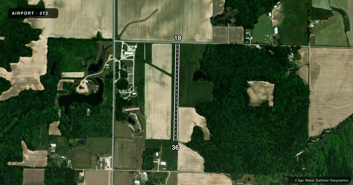
Airport sketch
Runways drawn to scale from FAA survey coordinates, rendered over satellite imagery. Not for navigation.
Approaches & charts
Services on the field
Fuel grades, oxygen, maintenance, ramp storage and lighting — as declared to the FAA by the airport operator.
Fuel & services
- Fuel
- Not available
- Oxygen (bottled)
- Not available
- Oxygen (bulk)
- Not available
- Airframe repair
- Not available
- Power plant repair
- Not available
Ramp & ground
- Transient storage
- Tie-down
- Landing fee
- No fee published
- Beacon schedule
- SS-SR
- Wind indicator
- Lighted
- Segmented circle
- No
Fuel & FBOs
Cheapest 100LL and Jet A on the field and nearby. Always confirm with the FBO before taxi.
Airport notes
Surface conditions, obstructions, local procedures, lighting outages and other notes published with each FAA cycle.
General notes
- PILOTS ADVD TO MNT 122.725 DUE TO CLOSE PROXIMITY OF EFFIMGHAM COUNTY MEML.
- PREDOMINANTLY ULTRALIGHT & STOL ACTIVITY ON & INVOF ARPT.
- EMS HELICOPTER OPERATION WITH EXTSV ACTIVITY IS BASED AT NORTH END OF THIS ARPT. OPERATION IS CONTINUOUS.
- FOR CD CTC KANSAS CITY ARTCC AT 913-254-8508.
Lighting notes
- FLASHING STROBE ON BLDG AT N END OF FIELD.
Runway surface & condition
- 18/36RWY HAS 300' STOPWAY AT NORTH END.
Approach & departure obstructions
- 18RY ENDS MKD WITH ONE ORANGE CONE ON EACH SIDE OF RY END.
Other notes
- LGTD WINDSOCK ON TOP OF BUILDING IS LGTD WITH FLOOD LGT, PRIMARILY FOR EMS ACTIVITY.
- MANAGEREMAIL ADDRESS: SHEILAPERCIVAL@YAHOO.COM (ALL LOWER CASE)
- MANAGERCELL PHONE: 217-994-6470
VFR map & nearby airports
VFR sectional. Tap any ICAO chip to open that airport.
Key facts · 2T2
Answer card- ICAO
- 2T2
- Name
- PERCIVAL SPRINGS
- Location
- WATSON, ILLINOIS
- Elevation
- 552 ft MSL
- Traffic pattern altitude
- 952 ft MSL (400 AGL)
- Control tower
- Non-towered (use CTAF)
- Total runways
- 1
- Longest runway
- 18/36 · 2,000 ft
- Published ILS approaches
- 0
- Published frequencies
- 1
- Magnetic variation
- 0°
- Current flight rules
- LIFR
- Current wind
- 150° at 6 kt
- Favored runway now
- RWY 18
Percival Springs is in Watson, Illinois. The field elevation is 552 ft MSL. It has one runway. Runway 18/36 is a 2,000 ft turf strip with magnetic headings 181° and 1°. The pattern altitude is 400 ft AGL, which is 952 ft MSL. There is no control tower. CTAF is 122.9.
No ILS approaches are published here. The airport sits in a mixed-use environment with predominantly ultralight and short takeoff and landing activity in and near the field. EMS helicopter operations are based at the north end and are continuous. That matters on arrival and departure. Expect to keep your scan active and stay alert for low and slow traffic. The published remarks also note a flashing strobe on the building at the north end. Runway 18 ends are marked with one orange cone on each side. Runway 18/36 also has a 300-foot stopway at the north end.
There are no on-field FBOs listed in the facts. Contact the airport operator directly before arrival, or call the field on CTAF for current FBO availability. For clearance delivery, contact Kansas City Air Route Traffic Control Center. Pilots are also advised to monitor 122.725 because of the close proximity of Effingham County Memorial. If you are planning a first visit, treat this as a small turf field with active local traffic and helicopter activity near the north end.