METAR & TAF KRSV
Current METAR
Observed 10:35Z
KRSV 271035Z AUTO 22003KT 6SM BR FEW033 22/22 A2991 RMK AO2 LTG DSNT E
- Wind
- 220° @ 3 kt
- Visibility
- 6 SM
- Temp / Dew
- 22°C / 22°C
- Altimeter
- 29.91 inHg
- Clouds
- FEW
- Density alt
- 1,424 ft
- Ceiling
- Unlimited
- Rules
- VFR
Airport info & contacts
Manager on record, flight service, ARTCC, attendance schedule and pattern altitude — published by the FAA and refreshed every 28 days.
Location
- From city
- 4 NM E
- VFR sectional
- ST LOUIS
- Pattern altitude
- 800 ft AGL · 1,261 ft MSL
- ARTCC
- ZID · INDIANAPOLIS
- NOTAM facility
- RSV (NOTAM-D)
Airport manager
- Name
- HOWARD HUNT
- Phone
- 217-932-2078
- Address
- 10748 NORTH 1650 ST, PALESTINE IL 62451
Flight service · Hours
- FSS STL
- SAINT LOUIS1-800-WX-BRIEF
- Attendance
- MON-FRI · 0900-1700
Frequencies
Tap any row to copy the frequency to your clipboard.
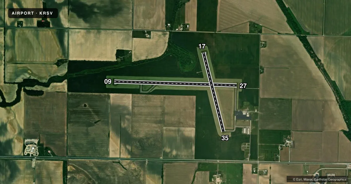
Runways & pattern
Full pagePattern entry · RWY 27
LEFT TRAFFIC| Runway | Heading (°M) | Length | Surface | Traffic |
|---|---|---|---|---|
| 09/27Favored | 89° / 269° | 5,108 ft | ASPH | Standard L |
| 17/35 | 163° / 343° | 3,398 ft | ASPH | Standard L |
Runway end performance
| End | TORA | TODA | ASDA | LDA | VGSI | Approach lights | Obstruction |
|---|---|---|---|---|---|---|---|
| 09 | — | — | — | — | PSIL(3°) | — | — |
| 27 | — | — | — | — | PSIL(3°) | — | — |
Declared distances in feet. TORA = takeoff run available, TODA = takeoff distance, ASDA = accelerate-stop, LDA = landing distance.
Airport sketch
Runways drawn to scale from FAA survey coordinates, rendered over satellite imagery. Not for navigation.
Approaches & charts
Services on the field
Fuel grades, oxygen, maintenance, ramp storage and lighting — as declared to the FAA by the airport operator.
Fuel & services
- Fuel
- 100LLA
- Oxygen (bottled)
- Not available
- Oxygen (bulk)
- Not available
- Airframe repair
- Major
- Power plant repair
- Major
- Other services
- INSTR,RNTL
Ramp & ground
- Transient storage
- Tie-down
- Hangar
- Landing fee
- No fee published
- Customs
- Not available
- Lighting schedule
- SEE RMK
- Beacon schedule
- SS-SR
- Beacon
- White / Green (civil land)(WG)
- Wind indicator
- Lighted
- Segmented circle
- Yes
Fuel & FBOs
Cheapest 100LL and Jet A on the field and nearby. Always confirm with the FBO before taxi.
Airport notes
Surface conditions, obstructions, local procedures, lighting outages and other notes published with each FAA cycle.
General notes
- FOR CD CTC HULMAN APCH AT 812-877-7581.
Lighting notes
- MIRL RY 09/27 PRESET ON LOW INTST; TO INCR INTST & ACTVT MIRL RY 17/35 , REIL RYS 09, 27 & 17 PVASI RYS 09 & 27 - CTAF.
VFR map & nearby airports
VFR sectional. Tap any ICAO chip to open that airport.
Key facts · KRSV
Answer card- ICAO
- KRSV
- Name
- CRAWFORD COUNTY
- Location
- ROBINSON, ILLINOIS
- Elevation
- 461.3 ft MSL
- Traffic pattern altitude
- 1,261.3 ft MSL (800 AGL)
- Control tower
- Non-towered (use CTAF)
- Total runways
- 2
- Longest runway
- 09/27 · 5,108 ft
- Published ILS approaches
- 0
- Published frequencies
- 4
- Magnetic variation
- 3°
- Current flight rules
- VFR
- Current wind
- 220° at 3 kt
- Favored runway now
- RWY 27
Crawford County Airport sits in Robinson, Illinois. Field elevation is 461.3 ft MSL. The airport has two asphalt runways. The longest is runway 09/27 at 5,108 ft. Runway 17/35 is 3,398 ft. There is no control tower. Pattern altitude is 800 ft AGL, which is 1,261.3 ft MSL.
No ILS approaches are published here. If you need an instrument arrival, check the current FAA Chart Supplement for the latest approach setup and any changes. The published remarks also matter here. Runway 09/27 lights come up in low intensity by default. Use CTAF to increase lighting intensity. Use CTAF to activate the runway end identifier lights and the precision visual approach slope indicators on 09 and 27. For clearance delivery, contact Hulman Approach at 812-877-7581.
Sky's The Limit is on the field. It carries 100LL and Jet A. For a first-time arrival, pay attention to the published lighting setup and the lack of a tower. Use the listed frequencies for traffic calls and coordinate with Hulman Approach when needed. The field sits in flat Illinois terrain, so the main planning items are runway length, lighting and current approach availability rather than terrain clearance.