METAR & TAF I20
I20 does not publish a METAR.
Showing the nearest reporting station: KLWV (LAWRENCEVILLE-VINCENNES INTL) · 7.1 NM away. Conditions at I20 may differ.
METAR · KLWV
Observed 17:53Z
KLWV 241753Z AUTO 05006KT 10SM SCT050 27/14 A3013 RMK AO2 SLP199 T02670139 10267 20167 58008
- Wind
- 050° @ 6 kt
- Visibility
- 10 SM
- Temp / Dew
- 27°C / 14°C
- Altimeter
- 30.13 inHg
- Clouds
- SCT
- Density alt
- 1,708 ft
- Ceiling
- Unlimited
- Rules
- VFR
Airport info & contacts
Manager on record, flight service, ARTCC, attendance schedule and pattern altitude — published by the FAA and refreshed every 28 days.
Location
- From city
- 3 NM SW
- VFR sectional
- ST LOUIS
- ARTCC
- ZID · INDIANAPOLIS
- NOTAM facility
- HUF
Airport manager
- Name
- EDWARD A. HUDDLESTON
- Phone
- (812) 745-2213
- Address
- 2253 EAST AIRPORT ROAD, OAKTOWN IN 47561
Flight service · Hours
- FSS HUF
- TERRE HAUTE1-800-WX-BRIEF
- Attendance
- IREG
Frequencies
Tap any row to copy the frequency to your clipboard.
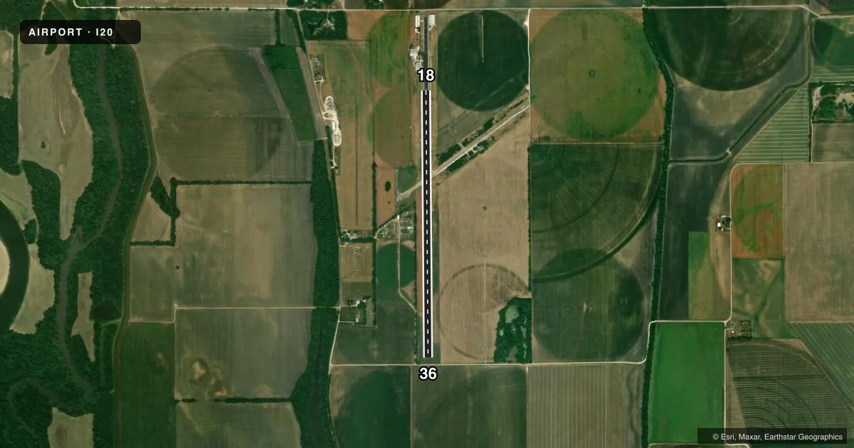
Runways & pattern
Full pagePattern entry · RWY 36
LEFT TRAFFICRunway end performance
| End | TORA | TODA | ASDA | LDA | VGSI | Approach lights | Obstruction |
|---|---|---|---|---|---|---|---|
| 18 | — | — | — | — | — | — | 12', tank, 295' from thr, 115' R of cntrln, slope 8 |
| 36 | — | — | — | — | — | — | 13', road, 316' from thr, slope 9 |
Declared distances in feet. TORA = takeoff run available, TODA = takeoff distance, ASDA = accelerate-stop, LDA = landing distance.
Airport sketch
Runways drawn to scale from FAA survey coordinates, rendered over satellite imagery. Not for navigation.
Approaches & charts
Services on the field
Fuel grades, oxygen, maintenance, ramp storage and lighting — as declared to the FAA by the airport operator.
Fuel & services
- Fuel
- Not available
- Airframe repair
- Minor
- Power plant repair
- Minor
Ramp & ground
- Transient storage
- Not published
- Landing fee
- No fee published
- Beacon schedule
- SEE RMK
- Beacon
- White / Green (civil land)(WG)
- Wind indicator
- Yes
- Segmented circle
- No
Fuel & FBOs
Cheapest 100LL and Jet A on the field and nearby. Always confirm with the FBO before taxi.
Airport notes
Surface conditions, obstructions, local procedures, lighting outages and other notes published with each FAA cycle.
General notes
- HNGR LCTD N END W SIDE OF RWY.
- FOR CD CTC HULMAN APCH AT 812-877-7581.
Lighting notes
- BCN OWNER USE ONLY.
Other notes
- EXISTED PRIOR TO 1959.
VFR map & nearby airports
VFR sectional. Tap any ICAO chip to open that airport.
Key facts · I20
Answer card- ICAO
- I20
- Name
- ED-AIR
- Location
- OAKTOWN, INDIANA
- Elevation
- 426 ft MSL
- Traffic pattern altitude
- 1,426 ft MSL (1,000 AGL)
- Control tower
- Non-towered (use CTAF)
- Total runways
- 1
- Longest runway
- 18/36 · 4,572 ft
- Published ILS approaches
- 0
- Published frequencies
- 2
- Magnetic variation
- 1°
- Current flight rules
- VFR
- Current wind
- 050° at 6 kt
- Favored runway now
- RWY 36
ED-AIR (I20) sits in Oaktown, Indiana. The field elevation is 426 ft MSL. It has one runway, 18/36, which is 4,572 ft long and paved asphalt. There is no control tower. CTAF and UNICOM are both 122.8.
No ILS approaches are published here. The pattern altitude is not published, so plan on the standard 1,000 ft AGL for light piston traffic unless the current Chart Supplement says otherwise. The airport uses a beacon for owner use only. Clearance delivery is handled through Hulman Approach at 812-877-7581. The hangar is at the north end on the west side of the runway.
For a first-time arrival, the main things to check are the non-towered flow and the single-runway layout. The runway heading is essentially north-south, with magnetic headings of 179.545747759701° and 359.545747759701°. That matters if you are planning a crosswind landing or a night arrival. There are no on-field FBOs listed. Verify services with the airport operator or call the field on CTAF before you go. If you need current noise, lighting, or operating notes, use the current FAA Chart Supplement before departure.