METAR & TAF KLWV
Current METAR
Observed 05:53Z
KLWV 260553Z AUTO 00000KT 3SM BR FEW015 22/22 A2998 RMK AO2 SLP148 T02220217 10239 20222 402440178 55006 $
- Wind
- 000° @ 0 kt
- Visibility
- 3 SM
- Temp / Dew
- 22°C / 22°C
- Altimeter
- 29.98 inHg
- Clouds
- FEW
- Density alt
- 1,299 ft
- Ceiling
- Unlimited
- Rules
- MVFR
Airport info & contacts
Manager on record, flight service, ARTCC, attendance schedule and pattern altitude — published by the FAA and refreshed every 28 days.
Location
- From city
- 3 NM NE
- VFR sectional
- ST LOUIS
- ARTCC
- ZID · INDIANAPOLIS
- NOTAM facility
- LWV (NOTAM-D)
Airport manager
- Name
- DEVON HILL
- Phone
- 618-943-5733
- Address
- 13608 HANGAR RD, LAWRENCEVILLE IL 62439
Flight service · Hours
- FSS STL
- SAINT LOUIS1-800-WX-BRIEF
- Attendance
- MON-FRI · 0700-1800
- SAT-SUN · 0900-1700
Frequencies
Tap any row to copy the frequency to your clipboard.
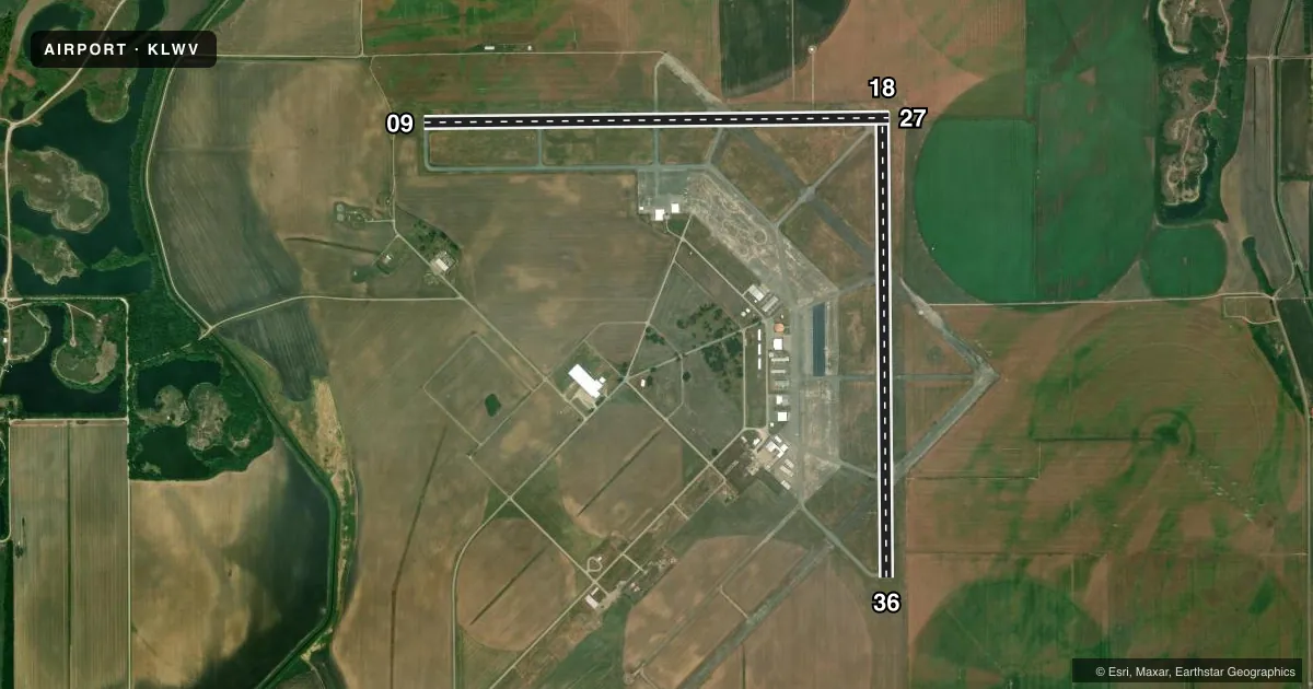
Runways & pattern
Full pagePattern entry · RWY 18
LEFT TRAFFIC| Runway | Heading (°M) | Length | Surface | Traffic |
|---|---|---|---|---|
| 18/36 | 178° / 358° | 5,199 ft | ASPH | Standard L |
| 09/27 | 88° / 268° | 5,198 ft | ASPH | Standard L |
Runway end performance
| End | TORA | TODA | ASDA | LDA | VGSI | Approach lights | Obstruction |
|---|---|---|---|---|---|---|---|
| 18 | — | — | — | — | PSIL(3°) | — | — |
| 36 | — | — | — | — | PAPI 4-box left(3°) | — | — |
| 09 | — | — | — | — | PSIL(3°) | — | — |
| 27 | — | — | — | — | PAPI 4-box left(3°) | ODALS | — |
Declared distances in feet. TORA = takeoff run available, TODA = takeoff distance, ASDA = accelerate-stop, LDA = landing distance.
Airport sketch
Runways drawn to scale from FAA survey coordinates, rendered over satellite imagery. Not for navigation.
Approaches & charts
Services on the field
Fuel grades, oxygen, maintenance, ramp storage and lighting — as declared to the FAA by the airport operator.
Fuel & services
- Fuel
- 100LLA
- Oxygen (bottled)
- Not available
- Oxygen (bulk)
- Not available
- Airframe repair
- Not available
- Power plant repair
- Not available
- Other services
- CHTR,INSTR,RNTL,SALES
Ramp & ground
- Transient storage
- Tie-down
- Hangar
- Landing fee
- No fee published
- Customs
- Not available
- Lighting schedule
- SEE RMK
- Beacon schedule
- SS-SR
- Beacon
- White / Green (civil land)(WG)
- Wind indicator
- Lighted
Fuel & FBOs
Cheapest 100LL and Jet A on the field and nearby. Always confirm with the FBO before taxi.
Airport notes
Surface conditions, obstructions, local procedures, lighting outages and other notes published with each FAA cycle.
General notes
- GLIDER ACTVTY SR-SS. RYS 09/27 & 18/36 HAVE LEFT HAND TFC PATTERN FOR GLIDER ACFT.
- BE ALERT; ODALS FOR RY 27 ARE IN OPERATION SIMULTANEOUSLY WITH REILS ON RY 18.
- FOR CD WHEN RCO 125.6 OTS, CTC EVANSVILLE APCH AT 812-436-4689, WHEN APCH CLSD CTC INDIANAPOLIS ARTCC AT 317-247-2411.
Lighting notes
- ACTVT ODALS RWY 27; REIL RWY 9, 27, 18 & 36; PAPI RWY 36; MIRL RWY 09/27 - CTAF. MIRL RWY 18/36 PRESET ON LOW INTST TO INCR INTST - CTAF.
Approach & departure obstructions
- 09PVASI UNUSBL BYD 8 DEGREES LEFT OF CNTRLN & BYD 6 DEGREES RIGHT OF CNTRLN.
- 18PVASI UNUSBL BYD 8 DEGREES LEFT OF CNTRLN & BYD 6 DEGREES RIGHT OF CNTRLN.
Other notes
- EXISTED PRIOR TO 1959.
- TRAFFIC PATTERN INDICATORS ON SOD RUNWAY 4U/22U
- RWY 09/27 & 18/36 900 FT AGL PWRD ACFT; RWY 04U/22U 500 FT AGL MAX ULTRALIGHTS.
- OWNERJOINT OWNED - CITY OF VINCENNES IN & LAWRENCEVILLE IL.
- MANAGER812-881-7042.
VFR map & nearby airports
VFR sectional. Tap any ICAO chip to open that airport.
Key facts · KLWV
Answer card- ICAO
- KLWV
- Name
- LAWRENCEVILLE-VINCENNES INTL
- Location
- LAWRENCEVILLE, ILLINOIS
- Elevation
- 429.8 ft MSL
- Traffic pattern altitude
- 1,429.8 ft MSL (1,000 AGL)
- Control tower
- Non-towered (use CTAF)
- Total runways
- 2
- Longest runway
- 18/36 · 5,199 ft
- Published ILS approaches
- 0
- Published frequencies
- 4
- Magnetic variation
- 1°
- Current flight rules
- MVFR
- Current wind
- 000° at 0 kt
- Favored runway now
- –
Lawrenceville-Vincennes Intl sits in Lawrenceville, Illinois near the Indiana border. Field elevation is 429.8 ft MSL. The airport has two asphalt runways. The longest is 5,199 ft. There is no control tower. CTAF and UNICOM are both 122.8. Approach and departure service is on 125.6 or 343.7 through Evansville. No ILS approaches are published here, so plan with the current chart and weather in mind.
Pattern altitude for powered aircraft on runways 09/27 and 18/36 is 900 ft AGL. That puts the traffic pattern at 1,329.8 ft MSL. Mid-American Air Center is on the field. It carries 100LL and Jet A. Call them at (618) 943-5733 for current services. The airport also has lighting features that matter at night. Runway 27 has omnidirectional approach lighting. Runway 36 has a PAPI. Runway end identifier lights are installed on 9, 27, 18 and 36. Runway lights on 09/27 are CTAF-controlled. Runway lights on 18/36 start low and can be increased by CTAF.
For a first-time arrival, watch the mixed-use traffic picture. Glider activity runs from sunrise to sunset. Runways 09/27 and 18/36 use left-hand patterns for gliders. The field is jointly owned by the City of Vincennes, Indiana and Lawrenceville, Illinois. Check the current Chart Supplement for any additional local procedures before you go.