METAR & TAF 1I3
1I3 does not publish a METAR.
Showing the nearest reporting station: KBMG (MONROE COUNTY) · 19.0 NM away. Conditions at 1I3 may differ.
METAR · KBMG
Observed 10:53Z
KBMG 241053Z 10SM CLR 12/12 A3016 RMK AO2 SLP208 T01170117 $
- Wind
- Calm
- Visibility
- 10 SM
- Temp / Dew
- 12°C / 12°C
- Altimeter
- 30.16 inHg
- Clouds
- CLR
- Density alt
- -36 ft
- Ceiling
- Unlimited
- Rules
- VFR
Airport info & contacts
Manager on record, flight service, ARTCC, attendance schedule and pattern altitude — published by the FAA and refreshed every 28 days.
Location
- From city
- 3 NM W
- VFR sectional
- ST LOUIS
- ARTCC
- ZID · INDIANAPOLIS
- NOTAM facility
- HUF (NOTAM-D)
Airport manager
- Name
- MELINDA HARVEY
- Phone
- 812-829-5999
- Address
- 3416 W STATE ROAD 54, BLOOMFIELD IN 47424
Flight service · Hours
- FSS HUF
- TERRE HAUTE1-800-WX-BRIEF
- Attendance
- UNATTENDED
Frequencies
Tap any row to copy the frequency to your clipboard.
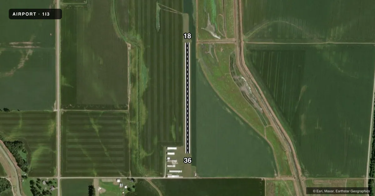
Runways & pattern
Full pagePattern entry · RWY 18
LEFT TRAFFICRunway end performance
| End | TORA | TODA | ASDA | LDA | VGSI | Approach lights | Obstruction |
|---|---|---|---|---|---|---|---|
| 18 | — | — | — | — | — | — | 10', crops, 200' from thr, 50' R of cntrln, slope 20 |
| 36 | — | — | — | — | — | — | 20', bldg, 275' from thr, 110' R of cntrln, slope 13 |
Declared distances in feet. TORA = takeoff run available, TODA = takeoff distance, ASDA = accelerate-stop, LDA = landing distance.
Airport sketch
Runways drawn to scale from FAA survey coordinates, rendered over satellite imagery. Not for navigation.
Approaches & charts
Services on the field
Fuel grades, oxygen, maintenance, ramp storage and lighting — as declared to the FAA by the airport operator.
Fuel & services
- Fuel
- Not available
- Airframe repair
- Minor
- Power plant repair
- Minor
Ramp & ground
- Transient storage
- Tie-down
- Hangar
- Landing fee
- No fee published
- Customs
- Not available
- Lighting schedule
- SS-SR
- Wind indicator
- Lighted
- Segmented circle
- No
Fuel & FBOs
Cheapest 100LL and Jet A on the field and nearby. Always confirm with the FBO before taxi.
Airport notes
Surface conditions, obstructions, local procedures, lighting outages and other notes published with each FAA cycle.
General notes
- 370'ANTENNA TWR 1 MI NW.
- RY 18/36 HAS A -4 FT SLOPE ON EAST SIDE; NORTH OF RY 18 THR.
- BIRDS ON & INVOF RY.
- ULTRA LGTS ON & INVOF ARPT.
- FOR CD CTC HULMAN APCH AT 812-877-7581.
Runway surface & condition
- 18/36485 FT STWY NORTH END.
- 18/36RY 18/36 NSTD EDGE LGTS, PCV PIPE WITH GLASS JARS.
Other notes
- PART TIME
- 2FOR ARPT ATNDNC CALL 812-825-5058.
VFR map & nearby airports
VFR sectional. Tap any ICAO chip to open that airport.
Key facts · 1I3
Answer card- ICAO
- 1I3
- Name
- SHAWNEE FLD
- Location
- BLOOMFIELD, INDIANA
- Elevation
- 501 ft MSL
- Traffic pattern altitude
- 1,501 ft MSL (1,000 AGL)
- Control tower
- Non-towered (use CTAF)
- Total runways
- 1
- Longest runway
- 18/36 · 2,160 ft
- Published ILS approaches
- 0
- Published frequencies
- 1
- Magnetic variation
- 1°
- Current flight rules
- VFR
- Current wind
- Calm / unavailable
- Favored runway now
- –
Shawnee Fld (1I3) sits in Bloomfield, Indiana. The field elevation is 501 ft MSL. It has one runway. Runway 18/36 is 2,160 ft of turf, so plan performance with soft-field technique in mind. The airport is non-towered. CTAF is 122.9. No ILS approaches are published here.
Pattern altitude is not published. For light piston traffic, use 1,000 ft AGL unless the current Chart Supplement or local procedures say otherwise. The published remarks matter here. Runway 18/36 has nonstandard edge lights. There is also a 485 ft stopway at the north end. Birds are reported on and near the runway. A 370 ft antenna tower sits about 1 mile northwest. There are ultraviolet lights on and in the vicinity of the airport. The east side north of the Runway 18 threshold has a minus 4 ft slope.
No on-field FBOs are listed. Contact the airport operator directly before arrival if you need services. Power plant repair service is part time. For clearance delivery, the Chart Supplement says to contact Hulman Approach. First-time visitors should also verify current traffic and any local operating notes before they go in. Keep an eye on the turf condition, the slope near the north end and the bird activity when planning a landing or departure.