METAR & TAF 0I2
0I2 does not publish a METAR.
Showing the nearest reporting station: KHUF (TERRE HAUTE RGNL) · 9.7 NM away. Conditions at 0I2 may differ.
METAR · KHUF
Observed 14:53Z
KHUF 271453Z 00000KT 10SM CLR 28/23 A2988 RMK AO2 SLP112 T02780233 58009
- Wind
- 000° @ 0 kt
- Visibility
- 10 SM
- Temp / Dew
- 28°C / 23°C
- Altimeter
- 29.88 inHg
- Clouds
- CLR
- Density alt
- 2,409 ft
- Ceiling
- Unlimited
- Rules
- VFR
Airport info & contacts
Manager on record, flight service, ARTCC, attendance schedule and pattern altitude — published by the FAA and refreshed every 28 days.
Location
- From city
- 3 NM S
- VFR sectional
- ST LOUIS
- ARTCC
- ZID · INDIANAPOLIS
- NOTAM facility
- HUF (NOTAM-D)
Airport manager
- Name
- CARL TROUT
- Phone
- 812-251-7021
- Address
- 475 E COUNTY RD 600 N, BRAZIL IN 47834
Flight service · Hours
- FSS HUF
- TERRE HAUTE1-800-WX-BRIEF
- Attendance
- Unattended
Frequencies
Tap any row to copy the frequency to your clipboard.
Runways & pattern
Full pagePattern entry · RWY 09
LEFT TRAFFICRunway end performance
| End | TORA | TODA | ASDA | LDA | VGSI | Approach lights | Obstruction |
|---|---|---|---|---|---|---|---|
| 09 | — | — | — | — | — | — | 76', trees, 880' from thr, 85' R of cntrln, slope 8 |
| 27 | — | — | — | — | — | — | 52', trees, 618' from thr, 0' R of cntrln, slope 8 |
Declared distances in feet. TORA = takeoff run available, TODA = takeoff distance, ASDA = accelerate-stop, LDA = landing distance.
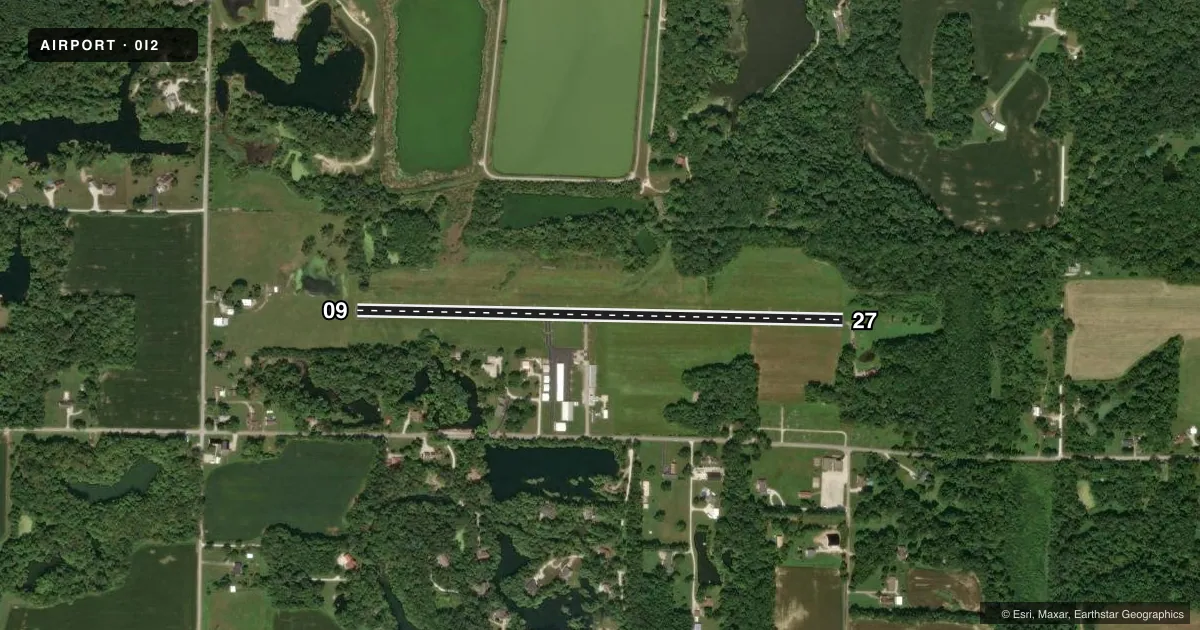
Airport sketch
Runways drawn to scale from FAA survey coordinates, rendered over satellite imagery. Not for navigation.
Approaches & charts
Services on the field
Fuel grades, oxygen, maintenance, ramp storage and lighting — as declared to the FAA by the airport operator.
Fuel & services
- Fuel
- 100LL
- Oxygen (bottled)
- Not available
- Oxygen (bulk)
- Not available
- Airframe repair
- Major
- Power plant repair
- Major
Ramp & ground
- Transient storage
- Tie-down
- Hangar
- Landing fee
- No fee published
- Customs
- Not available
- Lighting schedule
- SEE RMK
- Beacon schedule
- SS-SR
- Beacon
- White / Green (civil land)(WG)
- Wind indicator
- Lighted
- Segmented circle
- No
Fuel & FBOs
Cheapest 100LL and Jet A on the field and nearby. Always confirm with the FBO before taxi.
Airport notes
Surface conditions, obstructions, local procedures, lighting outages and other notes published with each FAA cycle.
General notes
- +80 FT WSW - ENE PLINE 4/5 MI N OF ARPT.
- LARGE FLOCKS OF GEESE ON & INVOF ARPT.
- FOR CD CTC HULMAN APCH AT 812-877-7581.
Lighting notes
- ACTVT LIRL RY 09/27 - CTAF 3 SLOW CLICKS .
Approach & departure obstructions
- 094 FT FENCE 28 FT FM RWY.
- 27PVT DRIVE 20 FT L.
- 2720 FT DEPRESSION E OF RWY END 100 FT N OF CNTRLN.
- 09APCH 19:1 TO DTHR.
- 27APCH 20:1 TO DTHR.
Other notes
- THIS AIRPORT HAS BEEN SURVEYED BY THE NATIONAL GEODETIC SURVEY.
- RESTRICTED TO VFR
VFR map & nearby airports
VFR sectional. Tap any ICAO chip to open that airport.
Key facts · 0I2
Answer card- ICAO
- 0I2
- Name
- BRAZIL CLAY COUNTY/CHARLES B HALL FLD
- Location
- BRAZIL, INDIANA
- Elevation
- 645 ft MSL
- Traffic pattern altitude
- 1,645 ft MSL (1,000 AGL)
- Control tower
- Non-towered (use CTAF)
- Total runways
- 1
- Longest runway
- 09/27 · 2,941 ft
- Published ILS approaches
- 0
- Published frequencies
- 5
- Magnetic variation
- 4°
- Current flight rules
- VFR
- Current wind
- 000° at 0 kt
- Favored runway now
- –
BRAZIL CLAY COUNTY/CHARLES B HALL FLD sits in Brazil, Indiana. The field elevation is 645 ft MSL. It has one runway. Runway 09/27 is 2,941 ft long and asphalt. There is no control tower. CTAF and UNICOM are both 122.8. No ILS approaches are published here, so plan for VFR work only. The airport remarks also say operations are restricted to visual flight rules.
Pattern altitude is not published. Use the standard 1,000 ft AGL pattern unless local procedures or the current FAA Chart Supplement say otherwise. That puts the light piston pattern at about 1,645 ft MSL. The published remarks matter here. Runway 09 has a displaced threshold with a steep approach clearance slope. Runway 27 also has a displaced threshold with a steep approach clearance slope. There is a 4-foot fence near runway 09. There is also a private drive close to runway 27. Large flocks of geese are reported on and near the airport. Low intensity runway lights on 09/27 are activated with three slow clicks on CTAF. For clearance delivery, contact Hulman Approach at 812-877-7581. If you are planning a first visit, keep the VFR-only status, the short runway and the obstacle notes in mind.