METAR & TAF KGPC
Current METAR
Observed 06:15Z
KGPC 270615Z AUTO 00000KT 5SM HZ OVC018 23/ A2992 RMK AO2 LTG DSNT W T0227////
- Wind
- 000° @ 0 kt
- Visibility
- 5 SM
- Temp / Dew
- —
- Altimeter
- 29.92 inHg
- Clouds
- OVC
- Density alt
- —
- Ceiling
- 1,800 ft AGL
- Rules
- MVFR
Airport info & contacts
Manager on record, flight service, ARTCC, attendance schedule and pattern altitude — published by the FAA and refreshed every 28 days.
Location
- From city
- 3 NM SE
- VFR sectional
- ST LOUIS
- ARTCC
- ZID · INDIANAPOLIS
- NOTAM facility
- HUF (NOTAM-D)
Airport manager
- Name
- P. DOUGLAS MILLER
- Phone
- 765-721-1289
- Address
- 1595 BALLARD LANE, PO BOX 318, GREENCASTLE IN 46135
Flight service · Hours
- FSS HUF
- TERRE HAUTE1-800-WX-BRIEF
- Attendance
- 0800-1630
Frequencies
Tap any row to copy the frequency to your clipboard.
Runways & pattern
Full pagePattern entry · RWY 18
LEFT TRAFFICRunway end performance
| End | TORA | TODA | ASDA | LDA | VGSI | Approach lights | Obstruction |
|---|---|---|---|---|---|---|---|
| 18 | — | — | — | — | PAPI 2-box left(3°) | — | 10', crops, 420' from thr, 0' R of cntrln, slope 22 |
| 36 | — | — | — | — | PAPI 2-box left(3°) | — | 13', road, 610' from thr, 280' R of cntrln, slope 31 |
Declared distances in feet. TORA = takeoff run available, TODA = takeoff distance, ASDA = accelerate-stop, LDA = landing distance.
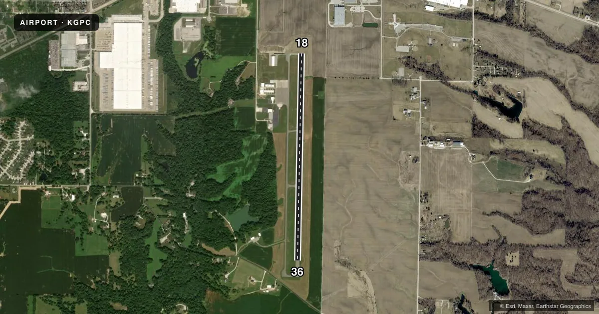
Airport sketch
Runways drawn to scale from FAA survey coordinates, rendered over satellite imagery. Not for navigation.
Approaches & charts
Services on the field
Fuel grades, oxygen, maintenance, ramp storage and lighting — as declared to the FAA by the airport operator.
Fuel & services
- Fuel
- 100LLA1+
- Airframe repair
- Major
- Power plant repair
- Major
- Other services
- INSTR,RNTL
Ramp & ground
- Transient storage
- Tie-down
- Hangar
- Landing fee
- No fee published
- Customs
- Not available
- Lighting schedule
- SEE RMK
- Beacon schedule
- SS-SR
- Beacon
- White / Green (civil land)(WG)
- Wind indicator
- Lighted
- Segmented circle
- No
Fuel & FBOs
Cheapest 100LL and Jet A on the field and nearby. Always confirm with the FBO before taxi.
Airport notes
Surface conditions, obstructions, local procedures, lighting outages and other notes published with each FAA cycle.
General notes
- FOR CD CTC INDIANAPOLIS APCH AT 317-227-5743.
Lighting notes
- ACTVT MIRL RWY 18/36 - CTAF; PAPI RWY 18 & 36 OPR CONSLY.
Approach & departure obstructions
- 18APCH RATIO 42:1 TO THR.
- 36APCH RATIO 46:1 TO THR.
Other notes
- EXISTED PRIOR TO 1959.
VFR map & nearby airports
VFR sectional. Tap any ICAO chip to open that airport.
Key facts · KGPC
Answer card- ICAO
- KGPC
- Name
- PUTNAM COUNTY RGNL
- Location
- GREENCASTLE, INDIANA
- Elevation
- 842 ft MSL
- Traffic pattern altitude
- 1,842 ft MSL (1,000 AGL)
- Control tower
- Non-towered (use CTAF)
- Total runways
- 1
- Longest runway
- 18/36 · 5,002 ft
- Published ILS approaches
- 0
- Published frequencies
- 4
- Magnetic variation
- 3°
- Current flight rules
- MVFR
- Current wind
- 000° at 0 kt
- Favored runway now
- –
Putnam County Rgnl is in Greencastle, Indiana. The field elevation is 842 ft MSL. It has one runway, 18/36 and the longest runway is 5,002 ft. There is no control tower. Pattern altitude is not published. Use 1,000 ft AGL for light piston traffic unless the current Chart Supplement says otherwise. That puts the pattern at 1,842 ft MSL.
No ILS approaches are published here. For IFR work, plan around the current approach setup and coordinate with Indianapolis Approach as needed. The published remarks also note that clearance delivery is handled through Indianapolis Approach at 317-227-5743. The runway lights on 18/36 are CTAF-activated. The PAPI for both runway ends operates continuously. That helps at night. You still want to verify the lighting status before departure.
PDM Aviation is on the field. It carries 100LL and Jet A. If you need fuel or local handling details, call them directly at (765) 721-1289 before you go. The runway approach slopes are also noted in the Chart Supplement, so watch your descent path on both ends. This is a non-towered airport with a single asphalt runway, so expect standard self-announce traffic flow on 122.8. Check the current Chart Supplement for any updated remarks before flying in.