METAR & TAF 3I3
3I3 does not publish a METAR.
Showing the nearest reporting station: KHUF (TERRE HAUTE RGNL) · 6.7 NM away. Conditions at 3I3 may differ.
METAR · KHUF
Observed 14:53Z
KHUF 271453Z 00000KT 10SM CLR 28/23 A2988 RMK AO2 SLP112 T02780233 58009
- Wind
- 000° @ 0 kt
- Visibility
- 10 SM
- Temp / Dew
- 28°C / 23°C
- Altimeter
- 29.88 inHg
- Clouds
- CLR
- Density alt
- 2,225 ft
- Ceiling
- Unlimited
- Rules
- VFR
Airport info & contacts
Manager on record, flight service, ARTCC, attendance schedule and pattern altitude — published by the FAA and refreshed every 28 days.
Location
- From city
- 5 NM N
- VFR sectional
- ST LOUIS
- ARTCC
- ZID · INDIANAPOLIS
- NOTAM facility
- HUF (NOTAM-D)
Airport manager
- Name
- CARROLL & CARROW LLC
- Phone
- 812-466-2229
- Address
- 6898 N. CLINTON ST, TERRE HAUTE IN 47805
Flight service · Hours
- FSS HUF
- TERRE HAUTE1-800-WX-BRIEF
- Attendance
- 0700-DUSK
Frequencies
Tap any row to copy the frequency to your clipboard.
Runways & pattern
Full pagePattern entry · RWY 09
LEFT TRAFFIC| Runway | Heading (°M) | Length | Surface | Traffic |
|---|---|---|---|---|
| 09/27 | 80° / 260° | 3,557 ft | ASPH | Standard L |
| 18/36 | 175° / 355° | 1,978 ft | ASPH | Standard L |
Runway end performance
| End | TORA | TODA | ASDA | LDA | VGSI | Approach lights | Obstruction |
|---|---|---|---|---|---|---|---|
| 09 | — | — | — | — | — | — | 60', trees, 1470' from thr, 0' R of cntrln, slope 20 |
| 27 | — | — | — | — | — | — | 92', trees, 688' from thr, 0' R of cntrln, slope 5 |
| 18 | — | — | — | — | — | — | 10', crops, 201' from thr, 0' R of cntrln, slope 0 |
| 36 | — | — | — | — | — | — | 27', tree, 201' from thr, 130' R of cntrln, slope 0 |
Declared distances in feet. TORA = takeoff run available, TODA = takeoff distance, ASDA = accelerate-stop, LDA = landing distance.
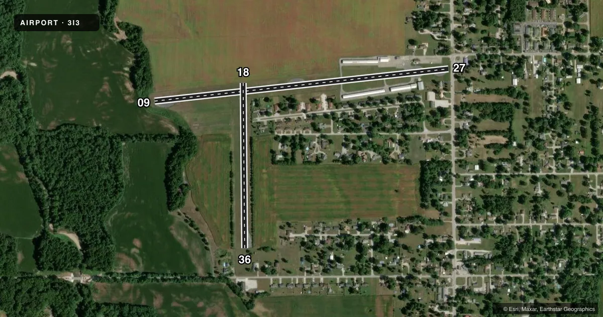
Airport sketch
Runways drawn to scale from FAA survey coordinates, rendered over satellite imagery. Not for navigation.
Approaches & charts
Services on the field
Fuel grades, oxygen, maintenance, ramp storage and lighting — as declared to the FAA by the airport operator.
Fuel & services
- Fuel
- 100LL
- Airframe repair
- Major
- Power plant repair
- Major
- Other services
- INSTR,RNTL
Ramp & ground
- Transient storage
- Hangar
- Landing fee
- No fee published
- Customs
- Not available
- Lighting schedule
- SEE RMK
- Beacon schedule
- SEE RMK
- Beacon
- White / Green (civil land)(WG)
- Wind indicator
- Yes
- Segmented circle
- No
Fuel & FBOs
Cheapest 100LL and Jet A on the field and nearby. Always confirm with the FBO before taxi.
Airport notes
Surface conditions, obstructions, local procedures, lighting outages and other notes published with each FAA cycle.
General notes
- FOR CD CTC HULMAN APCH AT 812-877-7581.
Lighting notes
- ACTVT ROTG BCN - CTAF.
- ACTVT LIRL RWY 09/27 & 18/36 - CTAF.
Approach & departure obstructions
- 2790 FT TREES 195 FT R OF RWY; 20 FT PLINE 40 FT FM RWY END; 50 FT TREES 125 FT FM RWY END.
- 366 FT FENCE 208 FT R OF RWY & 15 FT FM RWY END; 20 FT TREES 50 FT & 150 FT FM RWY END; 15 FT BRUSH 140 FT L OF RWY END.
- 0950 FT GND ELEV DROP 60 FT FM RWY THR.
- 18APCH SLOPE 20:1 TO DSPLCD THR.
- 27APCH SLP 16:1 TO DTHR.
- 36APCH SLOPE 17:1 TO DSPLCD THR.
Other notes
- THIS AIRPORT HAS BEEN SURVEYED BY THE NATIONAL GEODETIC SURVEY.
VFR map & nearby airports
VFR sectional. Tap any ICAO chip to open that airport.
Key facts · 3I3
Answer card- ICAO
- 3I3
- Name
- SKY KING
- Location
- TERRE HAUTE, INDIANA
- Elevation
- 496 ft MSL
- Traffic pattern altitude
- 1,496 ft MSL (1,000 AGL)
- Control tower
- Non-towered (use CTAF)
- Total runways
- 2
- Longest runway
- 09/27 · 3,557 ft
- Published ILS approaches
- 0
- Published frequencies
- 5
- Magnetic variation
- 4°
- Current flight rules
- VFR
- Current wind
- 000° at 0 kt
- Favored runway now
- –
SKY KING (3I3) sits in Terre Haute, Indiana at 496 ft MSL. It has two asphalt runways. The longest is 09/27 at 3,557 ft. The other runway is 18/36 at 1,978 ft. There is no control tower. CTAF and UNICOM are both 122.8. Hulman Approach handles clearance delivery and approach or departure services on the published frequencies.
No ILS approaches are published here. Pattern altitude is not published. Use the standard 1,000 ft AGL pattern for light piston traffic unless current local guidance says otherwise. Brown Flying School is on the field. It carries 100LL. Call them at (812) 466-2229 for current availability.
This field has a few runway-end issues worth briefing before you go. Runway 36 has a fence, trees and brush near the departure end. Runway 27 has tall trees and a power line near the end. Runway 18 has a displaced threshold with a published 20 to 1 approach slope. Runway 27 also has a displaced threshold with a published 15 to 1 approach slope. Runway 09 has a noticeable drop in terrain near the threshold. Low intensity runway lights are activated on CTAF. The rotating beacon is also activated on CTAF. For a first visit, plan your arrival with those obstructions in mind. Verify the current Chart Supplement before flying in.