METAR & TAF KSIV
KSIV does not publish a METAR.
Showing the nearest reporting station: KRSV (CRAWFORD COUNTY) · 11.1 NM away. Conditions at KSIV may differ.
METAR · KRSV
Observed 06:35Z
KRSV 270635Z AUTO 10001KT 6SM BR SCT038 23/23 A2988 RMK AO2
- Wind
- 100° @ 1 kt
- Visibility
- 6 SM
- Temp / Dew
- 23°C / 23°C
- Altimeter
- 29.88 inHg
- Clouds
- SCT
- Density alt
- 1,678 ft
- Ceiling
- Unlimited
- Rules
- VFR
Airport info & contacts
Manager on record, flight service, ARTCC, attendance schedule and pattern altitude — published by the FAA and refreshed every 28 days.
Location
- From city
- 3 NM NW
- VFR sectional
- ST LOUIS
- Pattern altitude
- 800 ft AGL · 1,339 ft MSL
- ARTCC
- ZID · INDIANAPOLIS
- NOTAM facility
- HUF (NOTAM-D)
Airport manager
- Name
- PAT HARMON
- Phone
- 812-268-6959
- Address
- 2001 N CR 200 W, SULLIVAN IN 47882
Flight service · Hours
- FSS HUF
- TERRE HAUTE1-800-WX-BRIEF
- Attendance
- MON-SAT · 0800-1700
- SUN · 1300-1700
Frequencies
Tap any row to copy the frequency to your clipboard.
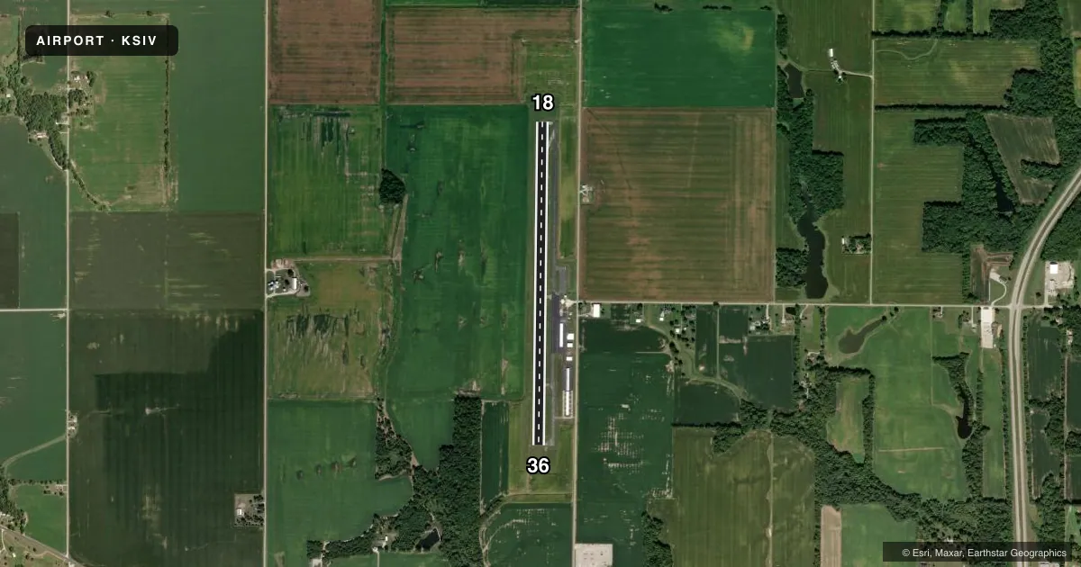
Runways & pattern
Full pagePattern entry · RWY 18
LEFT TRAFFICRunway end performance
| End | TORA | TODA | ASDA | LDA | VGSI | Approach lights | Obstruction |
|---|---|---|---|---|---|---|---|
| 18 | — | — | — | — | PAPI 2-box left(3°) | — | 10', crops, 380' from thr, 0' R of cntrln, slope 18 |
| 36 | — | — | — | — | PAPI 2-box left(3°) | — | 10', crops, 380' from thr, 0' R of cntrln, slope 18 |
Declared distances in feet. TORA = takeoff run available, TODA = takeoff distance, ASDA = accelerate-stop, LDA = landing distance.
Airport sketch
Runways drawn to scale from FAA survey coordinates, rendered over satellite imagery. Not for navigation.
Approaches & charts
Services on the field
Fuel grades, oxygen, maintenance, ramp storage and lighting — as declared to the FAA by the airport operator.
Fuel & services
- Fuel
- 100LLA
- Airframe repair
- Minor
- Power plant repair
- Minor
- Other services
- RNTL
Ramp & ground
- Transient storage
- Tie-down
- Hangar
- Landing fee
- No fee published
- Customs
- Not available
- Lighting schedule
- SEE RMK
- Beacon schedule
- SEE RMK
- Beacon
- White / Green (civil land)(WG)
- Wind indicator
- Lighted
- Segmented circle
- No
Fuel & FBOs
Cheapest 100LL and Jet A on the field and nearby. Always confirm with the FBO before taxi.
Airport notes
Surface conditions, obstructions, local procedures, lighting outages and other notes published with each FAA cycle.
General notes
- 153 FT TWR 6600 FT SE.
- MOORED BALLOON 2 MI E 1600 FT & BLW.
- FOR CD CTC HULMAN APCH AT 812-877-7581.
Lighting notes
- 24 HR.
- ACTVT REILS RWYS 18 & 36; MIRL RWY 18/36 - CTAF. PAPI RWY 18 & 36 OPR CONSLY.
Other notes
- 1UNATNDD JULY 4TH, MEMORIAL, THANKSGIVING, CHRISTMAS & NEW YEARS DAY.
VFR map & nearby airports
VFR sectional. Tap any ICAO chip to open that airport.
Key facts · KSIV
Answer card- ICAO
- KSIV
- Name
- SULLIVAN COUNTY
- Location
- SULLIVAN, INDIANA
- Elevation
- 539.2 ft MSL
- Traffic pattern altitude
- 1,339.2 ft MSL (800 AGL)
- Control tower
- Non-towered (use CTAF)
- Total runways
- 1
- Longest runway
- 18/36 · 4,359 ft
- Published ILS approaches
- 0
- Published frequencies
- 4
- Magnetic variation
- 2°
- Current flight rules
- VFR
- Current wind
- 100° at 1 kt
- Favored runway now
- RWY 18
Sullivan County Airport sits in Sullivan, Indiana. Field elevation is 539.2 ft MSL. The airport has one runway. Runway 18/36 is 4,359 ft long with asphalt surface. There is no control tower. Pattern altitude is 800 ft AGL, which is 1,339.2 ft MSL. No ILS approaches are published here.
The on-field FBO is Sullivan County Airport. It carries AVGAS 100LL and JET A. Call (812) 268-6959 for current service details before you go. CTAF and UNICOM are both 122.8. Approach and departure service is on 135.35 and 339.8 with Hulman. For clearance delivery, contact Hulman Approach at 812-877-7581.
A few published remarks matter for planning. Runway end identifier lights are on runways 18 and 36. Medium intensity runway lights are controlled by CTAF. The PAPI on both ends operates continuously. There is also a 153-foot tower 6,600 feet southeast. A moored balloon is 2 miles east at 1,600 feet and below. The beacon operates 24 hours. The airport is unattended on July 4th, Memorial Day, Thanksgiving, Christmas and New Year’s Day. Expect a non-towered arrival and keep the pattern tight at the published 800 ft AGL.