METAR & TAF 2R2
Current METAR
Observed 15:55Z
K2R2 031555Z AUTO 14008KT 10SM CLR 24/11 A3034 RMK AO2 T02420115 $
- Wind
- 140° @ 8 kt
- Visibility
- 10 SM
- Temp / Dew
- 24°C / 11°C
- Altimeter
- 30.34 inHg
- Clouds
- CLR
- Density alt
- 1,672 ft
- Ceiling
- Unlimited
- Rules
- VFR
Airport info & contacts
Manager on record, flight service, ARTCC, attendance schedule and pattern altitude — published by the FAA and refreshed every 28 days.
Location
- From city
- 13 NM W
- VFR sectional
- ST LOUIS
- ARTCC
- ZID · INDIANAPOLIS
- NOTAM facility
- HUF (NOTAM-D)
Airport manager
- Name
- KEITH BERLEN
- Phone
- (317) 487-5022
- Address
- 7800 COL. H. WEIR COOK MEMORIAL DR., SUITE 100, INDIANAPOLIS IN 46241
Flight service · Hours
- FSS HUF
- TERRE HAUTE1-800-WX-BRIEF
- Attendance
- MON-FRI · 0700-1530
Frequencies
Tap any row to copy the frequency to your clipboard.
Runways & pattern
Full pagePattern entry · RWY 18
LEFT TRAFFICRunway end performance
| End | TORA | TODA | ASDA | LDA | VGSI | Approach lights | Obstruction |
|---|---|---|---|---|---|---|---|
| 18 | — | — | — | — | PAPI 2-box left(3°) | — | — |
| 36 | — | — | — | — | PAPI 2-box left(3°) | — | 25', pline, 726' from thr, 230' R of cntrln, slope 21 |
Declared distances in feet. TORA = takeoff run available, TODA = takeoff distance, ASDA = accelerate-stop, LDA = landing distance.
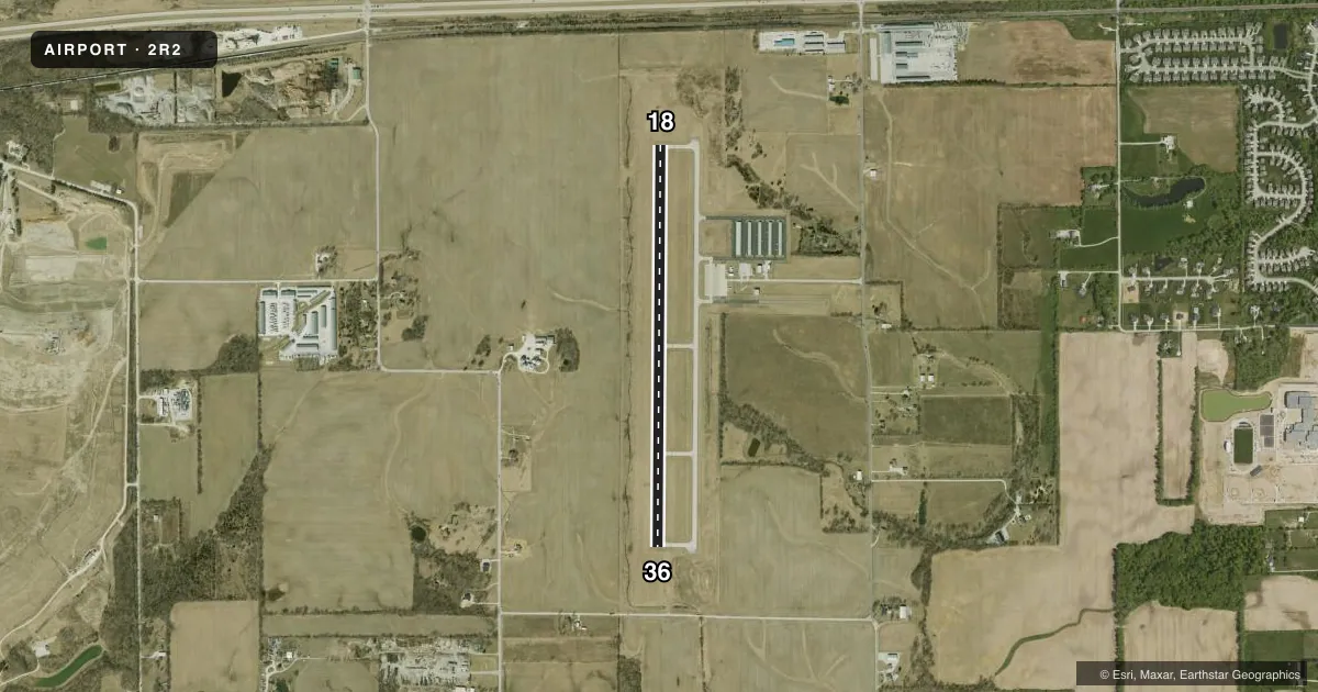
Airport sketch
Runways drawn to scale from FAA survey coordinates, rendered over satellite imagery. Not for navigation.
Approaches & charts
Services on the field
Fuel grades, oxygen, maintenance, ramp storage and lighting — as declared to the FAA by the airport operator.
Fuel & services
- Fuel
- 100LLMOGAS
- Other services
- INSTR,RNTL
Ramp & ground
- Transient storage
- Tie-down
- Hangar
- Lighting schedule
- SEE RMK
- Beacon
- White / Green (civil land)(WG)
- Wind indicator
- Lighted
- Segmented circle
- Yes
Fuel & FBOs
Cheapest 100LL and Jet A on the field and nearby. Always confirm with the FBO before taxi.
Airport notes
Surface conditions, obstructions, local procedures, lighting outages and other notes published with each FAA cycle.
General notes
- MODEL ACFT ACT BLW 1 NM W OF RWY 18 THR BLW 400 FT.
- FOR CD CTC INDIANAPOLIS APCH AT 317-227-5743.
- ACFT TKOF/LDG FM RWY 18 DURG CALM WIND/XWIND CONDS; DURG ANY QUESTIONABLE PD RWY 18 SHALL BE PREFERRED RWY - CALL AMGR 317-487-9594.
Lighting notes
- ACTVT REIL RWY 18 & 36; MIRL RWY 18/36 - CTAF. MIRL RWY 18/36 PRESET TO LOW INTST; INCR INTST - CTAF.
VFR map & nearby airports
VFR sectional. Tap any ICAO chip to open that airport.
Key facts · 2R2
Answer card- ICAO
- 2R2
- Name
- HENDRICKS COUNTY-GORDON GRAHAM FLD
- Location
- INDIANAPOLIS, INDIANA
- Elevation
- 897.8 ft MSL
- Traffic pattern altitude
- 1,897.8 ft MSL (1,000 AGL)
- Control tower
- Non-towered (use CTAF)
- Total runways
- 1
- Longest runway
- 18/36 · 4,400 ft
- Published ILS approaches
- 0
- Published frequencies
- 4
- Magnetic variation
- 3°
- Current flight rules
- VFR
- Current wind
- 140° at 8 kt
- Favored runway now
- RWY 18
Hendricks County-Gordon Graham Fld (2R2) sits in Indianapolis, Indiana at 897.8 ft MSL. It has one runway, 18/36, which is 4,400 ft of asphalt. There is no control tower. CTAF and UNICOM are both 122.7. Indianapolis Approach and Departure are on 121.1 and 119.05. No ILS approaches are published here.
The pattern altitude is not published. Use standard 1,000 ft AGL for light piston traffic unless the current Chart Supplement says otherwise. The field has runway end identifier lights on 18 and 36. Medium intensity runway lights are available for 18/36. They are controlled on CTAF. The remarks also say runway 18 is the preferred runway during calm wind or questionable conditions. Call the airport manager if you need the current local preference. Model aircraft activity is reported below 400 ft within 1 NM west of the runway 18 threshold, so keep that in mind on departure and arrival.
Hendricks County Airport is the on-field FBO. It carries 100LL and MOGAS. For clearance delivery, contact Indianapolis Approach. If you need any operational detail that is not published here, verify it with the current FAA Chart Supplement or call the airport operator directly.