METAR & TAF 6I4
6I4 does not publish a METAR.
Showing the nearest reporting station: KTYQ (INDIANAPOLIS EXEC) · 8.8 NM away. Conditions at 6I4 may differ.
METAR · KTYQ
Observed 11:35Z
KTYQ 241135Z AUTO 00000KT 10SM CLR 12/11 A3016 RMK AO2 T01200111
- Wind
- 000° @ 0 kt
- Visibility
- 10 SM
- Temp / Dew
- 12°C / 11°C
- Altimeter
- 30.16 inHg
- Clouds
- CLR
- Density alt
- 532 ft
- Ceiling
- Unlimited
- Rules
- VFR
Airport info & contacts
Manager on record, flight service, ARTCC, attendance schedule and pattern altitude — published by the FAA and refreshed every 28 days.
Location
- From city
- 2 NM SE
- VFR sectional
- CHICAGO
- Pattern altitude
- 941 ft AGL · 1,900 ft MSL
- ARTCC
- ZID · INDIANAPOLIS
- NOTAM facility
- HUF (NOTAM-D)
Airport manager
- Name
- EARL BROSMAN
- Phone
- 765-482-0940
- Address
- 1600 E 250 S, LEBANON IN 46052
Flight service · Hours
- FSS HUF
- TERRE HAUTE1-800-WX-BRIEF
- Attendance
- IRREGULAR
Frequencies
Tap any row to copy the frequency to your clipboard.
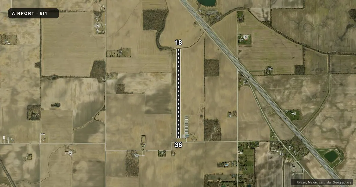
Runways & pattern
Full pagePattern entry · RWY 18
LEFT TRAFFICRunway end performance
| End | TORA | TODA | ASDA | LDA | VGSI | Approach lights | Obstruction |
|---|---|---|---|---|---|---|---|
| 18 | — | — | — | — | — | — | 10', crops, 201' from thr, 0' R of cntrln, slope 0 |
| 36 | — | — | — | — | — | — | 65', tree, 610' from thr, 110' R of cntrln, slope 6 |
Declared distances in feet. TORA = takeoff run available, TODA = takeoff distance, ASDA = accelerate-stop, LDA = landing distance.
Airport sketch
Runways drawn to scale from FAA survey coordinates, rendered over satellite imagery. Not for navigation.
Approaches & charts
Services on the field
Fuel grades, oxygen, maintenance, ramp storage and lighting — as declared to the FAA by the airport operator.
Fuel & services
- Fuel
- Not available
- Oxygen (bottled)
- Not available
- Oxygen (bulk)
- Not available
- Airframe repair
- Not available
- Power plant repair
- Not available
Ramp & ground
- Transient storage
- Tie-down
- Hangar
- Landing fee
- No fee published
- Customs
- Not available
- Lighting schedule
- SEE RMK
- Beacon schedule
- SS-SR
- Beacon
- White / Green (civil land)(WG)
- Wind indicator
- Lighted
- Segmented circle
- No
Fuel & FBOs
Cheapest 100LL and Jet A on the field and nearby. Always confirm with the FBO before taxi.
Airport notes
Surface conditions, obstructions, local procedures, lighting outages and other notes published with each FAA cycle.
General notes
- -3 FT DRAINAGE DITCH WITHIN PRIM SFC FM 50 FT E & 50 FT W OF CL.
- ULTRALGTS ON & INVOF ARPT.
- FOR CD CTC INDIANAPOLIS APCH AT 317-227-5743.
Lighting notes
- ACTVT LIRL RWY 18/36 - CTAF
Runway surface & condition
- 18/36RWY 18/36 NSTD LIRL - LIGHTS 24' FROM RWY EDGE.
Approach & departure obstructions
- 18RWY 18 -15 FT CREEK 37 FT FM RY END ON CNTRLN; 5 FT BRUSH 80 FT FM RY END.
- 36RWY 36 15 FT ROAD, 110 FT FR RWY END.
- 36RY 36 APCH RATIO 12:1 TO DSPLCD THR.
- 36CROPS
Other notes
- 18/36LOOSE GRAVEL & CRACKS.
VFR map & nearby airports
VFR sectional. Tap any ICAO chip to open that airport.
Key facts · 6I4
Answer card- ICAO
- 6I4
- Name
- BOONE COUNTY
- Location
- LEBANON, INDIANA
- Elevation
- 959 ft MSL
- Traffic pattern altitude
- 1,900 ft MSL (941 AGL)
- Control tower
- Non-towered (use CTAF)
- Total runways
- 1
- Longest runway
- 18/36 · 3,600 ft
- Published ILS approaches
- 0
- Published frequencies
- 2
- Magnetic variation
- 2°
- Current flight rules
- VFR
- Current wind
- 000° at 0 kt
- Favored runway now
- –
Boone County Airport sits in Lebanon, Indiana. The field elevation is 959 ft MSL. It has one runway. Runway 18/36 is 3,600 ft long with a concrete surface. There is no control tower. CTAF and UNICOM are both 122.7. No ILS approaches are published.
Pattern altitude is 941 ft AGL, which is 1,900 ft MSL. That matters here because the airport has several published surface and runway-end items to watch. Runway 18/36 has loose gravel and cracks. Runway 18 has a creek close to the end of the runway on centerline. There is also brush near that end. Runway 36 has a road close to the runway end. Crops are also noted near runway 36. The runway lights are low intensity. They are activated on 122.7. The lights are also set 24 ft from the runway edge, so plan your night setup carefully.
There are no on-field FBOs listed in the facts. Contact the airport operator or the field directly before arrival if you need fuel or ramp details. Clearance delivery is handled through Indianapolis Approach at 317-227-5743. Ultralights are on and in the vicinity of the airport, so expect mixed traffic and keep your scan active.