METAR & TAF I72
I72 does not publish a METAR.
Showing the nearest reporting station: KTYQ (INDIANAPOLIS EXEC) · 4.5 NM away. Conditions at I72 may differ.
METAR · KTYQ
Observed 10:55Z
KTYQ 261055Z AUTO 00000KT 3/4SM BR OVC002 20/20 A2999 RMK AO2 T02000195
- Wind
- 000° @ 0 kt
- Visibility
- 0.75 SM
- Temp / Dew
- 20°C / 20°C
- Altimeter
- 29.99 inHg
- Clouds
- OVC
- Density alt
- 1,669 ft
- Ceiling
- 200 ft AGL
- Rules
- LIFR
Airport info & contacts
Manager on record, flight service, ARTCC, attendance schedule and pattern altitude — published by the FAA and refreshed every 28 days.
Location
- From city
- 2 NM W
- VFR sectional
- CHICAGO
- ARTCC
- ZID · INDIANAPOLIS
- NOTAM facility
- HUF (NOTAM-D)
Airport manager
- Name
- ANDY WHEELER
- Phone
- 317-507-8281
- Address
- 18206 KINSEY AVE, WESTFIELD IN 46074
Flight service · Hours
- FSS HUF
- TERRE HAUTE1-800-WX-BRIEF
- Attendance
- IREG
Frequencies
Tap any row to copy the frequency to your clipboard.
Runways & pattern
Full pagePattern entry · RWY 18
LEFT TRAFFICRunway end performance
| End | TORA | TODA | ASDA | LDA | VGSI | Approach lights | Obstruction |
|---|---|---|---|---|---|---|---|
| 18 | — | — | — | — | — | — | 10', crops, 200' from thr, 0' R of cntrln, slope 20 |
| 36 | — | — | — | — | — | — | 45', trees, 845' from thr, 160' R of cntrln, slope 18 |
Declared distances in feet. TORA = takeoff run available, TODA = takeoff distance, ASDA = accelerate-stop, LDA = landing distance.
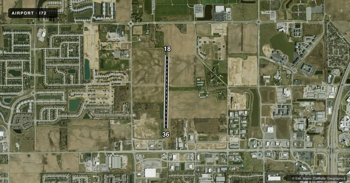
Airport sketch
Runways drawn to scale from FAA survey coordinates, rendered over satellite imagery. Not for navigation.
Approaches & charts
Services on the field
Fuel grades, oxygen, maintenance, ramp storage and lighting — as declared to the FAA by the airport operator.
Fuel & services
- Fuel
- Not available
Ramp & ground
- Transient storage
- Not published
- Landing fee
- No fee published
- Customs
- Not available
- Lighting schedule
- SEE RMK
- Wind indicator
- Yes
- Segmented circle
- No
Fuel & FBOs
Cheapest 100LL and Jet A on the field and nearby. Always confirm with the FBO before taxi.
Airport notes
Surface conditions, obstructions, local procedures, lighting outages and other notes published with each FAA cycle.
General notes
- SNOW REMOVAL NA.
- CROPS 50 FT EACH SIDE OF RWY CNTRLN.
- TREES, BUSHES & FENCE 100 FT W OF CNTRLN; PENETRATE PRIM SFC AREA.
- FOR CD CTC INDIANAPOLIS APCH AT 317-227-5743.
Lighting notes
- ON REQ - AMGR.
Runway surface & condition
- 18/36320 FT LGT TWR 900 FT W OF RWY.
Approach & departure obstructions
- 18ORANGE CONES.
- 36ORANGE CONES.
- 18PWR LINES APCH END.
Other notes
- EXISTED PRIOR TO 1959.
VFR map & nearby airports
VFR sectional. Tap any ICAO chip to open that airport.
Key facts · I72
Answer card- ICAO
- I72
- Name
- WESTFIELD
- Location
- WESTFIELD, INDIANA
- Elevation
- 932 ft MSL
- Traffic pattern altitude
- 1,932 ft MSL (1,000 AGL)
- Control tower
- Non-towered (use CTAF)
- Total runways
- 1
- Longest runway
- 18/36 · 3,000 ft
- Published ILS approaches
- 0
- Published frequencies
- 1
- Magnetic variation
- 2°
- Current flight rules
- LIFR
- Current wind
- 000° at 0 kt
- Favored runway now
- –
Westfield Airport (I72) is in Westfield, Indiana. The field elevation is 932 ft MSL. It has one runway. The longest runway is 3,000 ft of turf, runway 18/36. The airport is non-towered. CTAF is 122.9.
No ILS approaches are published here. The pattern altitude is not published, so use the standard 1,000 ft AGL for light piston operations unless the current Chart Supplement says otherwise. That puts the pattern at 1,932 ft MSL based on the listed field elevation.
There are no on-field FBOs listed in the facts. FBO options vary. Contact the airport operator directly before arrival. You can also call the field on CTAF or UNICOM for current FBO availability. Published remarks also note that lighting is available on request from the airport manager. Snow removal is not available.
A first-time pilot should pay close attention to the runway environment. Power lines are at the approach end of runway 18. Crops sit close to both sides of the centerline. Trees, bushes and a fence are west of the runway. They penetrate the primary surface area. There is also a 320-foot light tower 900 feet west of the runway. Clearance delivery for IFR departures goes through Indianapolis Approach. Check the current Chart Supplement for any published noise or curfew restrictions before flying into the field.