METAR & TAF KAJG
Current METAR
Observed 06:15Z
KAJG 270615Z AUTO 17005KT 10SM CLR 23/22 A2989 RMK AO2 LTG DSNT SW THRU NW T02260222
- Wind
- 170° @ 5 kt
- Visibility
- 10 SM
- Temp / Dew
- 23°C / 22°C
- Altimeter
- 29.89 inHg
- Clouds
- CLR
- Density alt
- 1,530 ft
- Ceiling
- Unlimited
- Rules
- VFR
Airport info & contacts
Manager on record, flight service, ARTCC, attendance schedule and pattern altitude — published by the FAA and refreshed every 28 days.
Location
- From city
- 12 NM N
- VFR sectional
- ST LOUIS
- ARTCC
- ZID · INDIANAPOLIS
- NOTAM facility
- AJG (NOTAM-D)
Airport manager
- Name
- LUIS GARCIA
- Phone
- 618-948-2413
- Address
- 10188 MT CARMEL AIRPORT LN, ST FRANCISVILLE IL 62460
Flight service · Hours
- FSS STL
- SAINT LOUIS1-800-WX-BRIEF
- Attendance
- 0800-1700
Frequencies
Tap any row to copy the frequency to your clipboard.
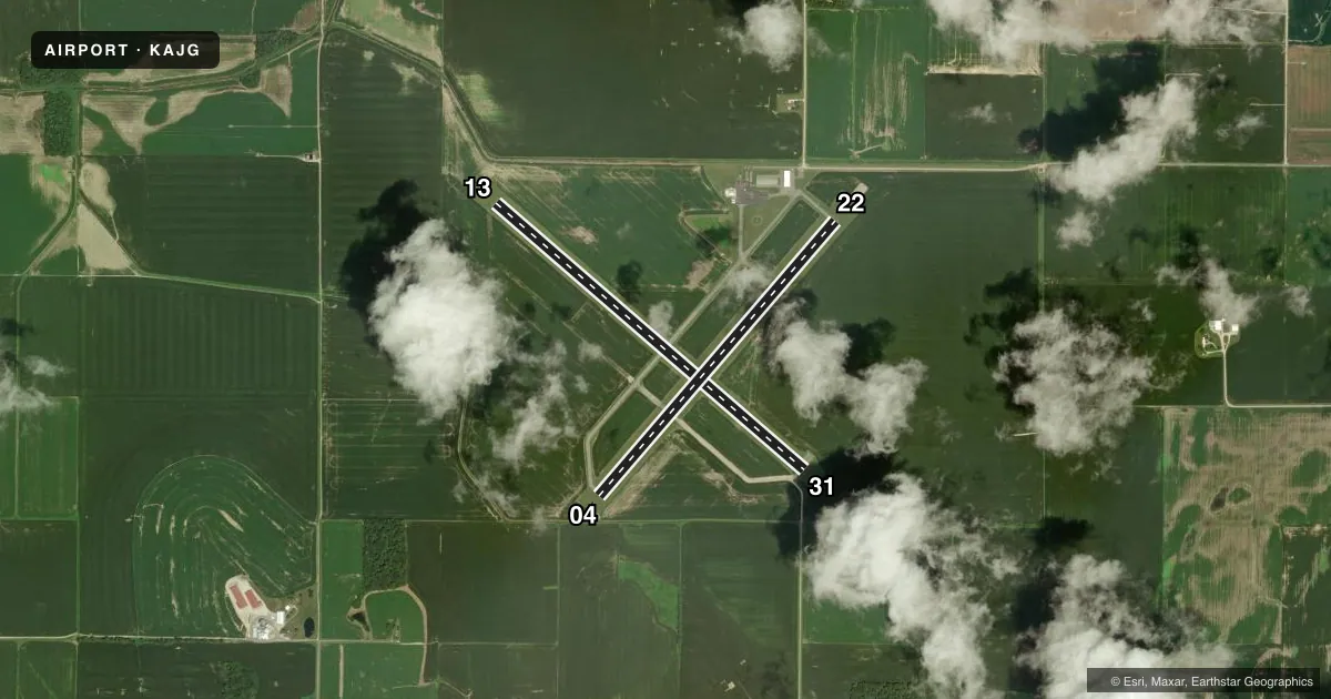
Runways & pattern
Full pagePattern entry · RWY 13
LEFT TRAFFIC| Runway | Heading (°M) | Length | Surface | Traffic |
|---|---|---|---|---|
| 13/31Favored | 129° / 309° | 4,500 ft | ASPH | Standard L |
| 04/22 | 39° / 219° | 4,000 ft | ASPH | Standard L |
Runway end performance
| End | TORA | TODA | ASDA | LDA | VGSI | Approach lights | Obstruction |
|---|---|---|---|---|---|---|---|
| 13 | — | — | — | — | PSIL(3°) | — | — |
| 31 | — | — | — | — | PSIL(3°) | — | — |
| 04 | — | — | — | — | PSIL(3°) | — | — |
| 22 | — | — | — | — | PSIL(3°) | — | — |
Declared distances in feet. TORA = takeoff run available, TODA = takeoff distance, ASDA = accelerate-stop, LDA = landing distance.
Airport sketch
Runways drawn to scale from FAA survey coordinates, rendered over satellite imagery. Not for navigation.
Approaches & charts
Services on the field
Fuel grades, oxygen, maintenance, ramp storage and lighting — as declared to the FAA by the airport operator.
Fuel & services
- Fuel
- 100LLA
- Oxygen (bottled)
- Not available
- Oxygen (bulk)
- Not available
- Airframe repair
- Minor
- Power plant repair
- Minor
- Other services
- AGRI,INSTR,RNTL,SALES
Ramp & ground
- Transient storage
- Tie-down
- Hangar
- Landing fee
- No fee published
- Customs
- Not available
- Lighting schedule
- SEE RMK
- Beacon schedule
- SS-SR
- Beacon
- White / Green (civil land)(WG)
- Wind indicator
- Lighted
- Segmented circle
- Yes
Fuel & FBOs
Cheapest 100LL and Jet A on the field and nearby. Always confirm with the FBO before taxi.
Airport notes
Surface conditions, obstructions, local procedures, lighting outages and other notes published with each FAA cycle.
General notes
- SELF SVC FUEL AVBL H24 WITH CREDIT CARD.
- FOR CD CTC EVANSVILLE APCH AT 812-436-4690, WHEN APCH CLSD CTC INDIANAPOLIS ARTCC AT 317-247-2411.
Lighting notes
- ACTVT REIL RWY 04, 13, 22 & 31; PVASI RWY 04, 13, 22 & 31; MIRL RWY 13/31- CTAF. MIRL RWY 04/22 PRESET ON LOW INTST TO INCR INTST - CTAF.
Approach & departure obstructions
- 04PVASI UNUSBL BYD 5 DEG LEFT & RIGHT OF CNTRLN.
- 13PVASI UNUSBL BYD 5 DEG LEFT & RIGHT OF CNTRLN.
- 22PVASI UNUSBL BYD 5 DEG LEFT & RIGHT OF CNTRLN.
- 31PVASI UNUSBL BYD 5 DEG LEFT & RIGHT OF CNTRLN.
Other notes
- EXISTED PRIOR TO 1959.
- MANAGEREMAIL ADDRESS: AJGAIRPORT@GMAIL.COM (ALL LOWER CASE)
VFR map & nearby airports
VFR sectional. Tap any ICAO chip to open that airport.
Key facts · KAJG
Answer card- ICAO
- KAJG
- Name
- MOUNT CARMEL MUNI
- Location
- MOUNT CARMEL, ILLINOIS
- Elevation
- 429.4 ft MSL
- Traffic pattern altitude
- 1,429.4 ft MSL (1,000 AGL)
- Control tower
- Non-towered (use CTAF)
- Total runways
- 2
- Longest runway
- 13/31 · 4,500 ft
- Published ILS approaches
- 0
- Published frequencies
- 4
- Magnetic variation
- 2°
- Current flight rules
- VFR
- Current wind
- 170° at 5 kt
- Favored runway now
- RWY 13
Mount Carmel Muni sits in Mount Carmel, Illinois. The field elevation is 429.4 ft MSL. It has two asphalt runways. The longest is 4,500 ft on runway 13/31. There is no control tower. CTAF and UNICOM are both 122.7. Approach and departure service is handled by Evansville on 125.6 and 343.7. No ILS approaches are published.
Pattern altitude is not published. Use the standard 1,000 ft AGL pattern unless current local guidance says otherwise. The field has one on-field FBO, Mount Carmel Municipal Airport. It carries 100LL and Jet A. Self-service fuel is available 24 hours a day with a credit card.
A few runway lighting details matter here. Runway end identifier lights are installed on 04, 13, 22 and 31. PAPI is installed on all four runway ends. Runways 13/31 have medium intensity lights controlled by CTAF. Runways 04/22 are preset low intensity. The PAPI is unusable more than 5 degrees left or right of centerline on each runway end, so stay lined up on final. For clearance delivery, contact Evansville Approach. If approach is closed, contact Indianapolis ARTCC. This is a non-towered field. Plan your calls early. Stay sharp in the pattern.